| |
|
The Nature Reserve of the Farma, situated between Monticiano and Roccastrada, includes the beautiful, wild valley which hosts the Farma torrent. Today, the Valley of the Farma is practically unpopulated. In the past, however, it was full of roads or trails that formed a network of small hamlets where citizen’s used the river for mills and iron work (constructing antique buildings for working iron ore).
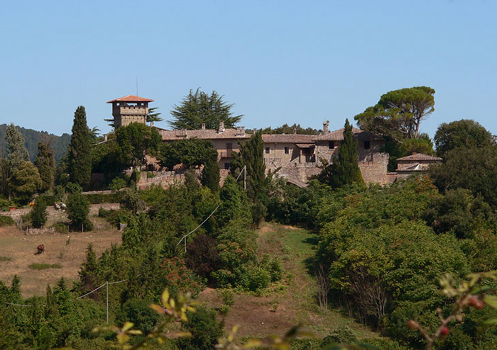
The Belagaio castle is an ancient feudal castle in the middle of the wood, that was a property of various powerful families of the area: Aldobrandeschi family, S. Lorenzo al Lanzo Abbey, Ardengheschi family and finally the Grottanelli family. It was precisely the Count Lorenzo Grottanelli who was responsible for transforming the castle into a villa with farm, although its original charm can still be admired through the recognisable architectonic elements that identify it as a castle, namely the walls, the tower, the noble chapel, the well and storehouses.
Since 1970's the fortress has been owned by the State Forestry Department, which is currently using it as a farmhouse to breed horses and cattle.
The State Nature Reserve of the Belagaio is part of the system of Farma-Merse Nature Reserves, consisting of a varied collection of environments grouped together by means of areas of integration and for programmes of management and preservation. Part of the territory of the Reserve is kept fit for seed (for the production of forage for horses) and a part is wooded, on the slopes of the Farma torrent. Inside the Reserve there is the Castle of Belagaio with other historical buildings.
The itinerary
|
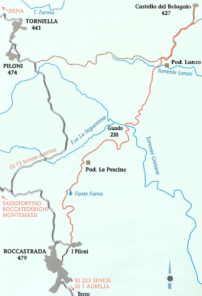 |
Map Roccastrada to Belagaio Castle
|
Development: Km 14,6 | Time: 4.50 hours
Interests | Historical Architectural (Belagaio Castle) | Geological (outcrop of Rhyolite in the Pescine's area) | Botanical (durmast-corkturkey
wood on Lanzo torrent and monumental turkey trees on Belagaio road)
It is a bit difficult only in the trail that from the Gretano torrent goes up the slope of Poggio al Sugherone,
almost the entire itinerary runs on cartways, through fields and woods. half way to Roccastada we suggest
covering the route when it is cool. Water can be fetched along the route.
This itinerary leads us to the Farma valley, a very interesting environment under both the ecological and the botanical aspect. On the hill that goes down from Roccastrada to the Gretano torrent, we get through crops and Mediterranean macchia. It is a varied landscape divided into small fields which are very fertile thanks to the presence of Rhyolite rocks(that we can see emerging just beyond a farm called "Le Pescine"). We then find two springs: the first one is named "Fonte Forna", from which locals once fetched its pure waters.
On reaching the Gretano torrent, we cross the border between the two municipalities of Civitella Paganico and Roccastrada; we cross it all the way up. We then enter a wood of holm , cork , turkey oaks ,durmast and arbustus trees. The soil has also changed: we find Verrucano rock instead of rhyolite. Going down we come into a forest of impressive Turkey oaks that takes us as far as the gravel stone road of Belagaio: at its sides secular Turkey oaks give the road a solemn look. These oaks have been preciously kept by the Grottenelli family. We then arrive to the castle of Belagaio, which was built in the twelfth century but it has been entirely restored. The state bought it in 1969.The castle surrounded by lovely hills, fields and grazing Maremma horses , gives a suggestive and relaxing atmosphere.
|
Belagaio Castle
|
Enlarge map
|
The elegant complex of Belagaio (a castle-farm) is located in the town of Roccastrada, on the border of the province of Siena. The complex rises up from the top of a small knoll near the Farma creek and it can be reached by following a path that winds through stupendous landscape.
This ancient fortified structure belonged to the Ardengheschi family in the 12th century. In the following century, it was taken over by the Siena’s city administration. After a slump during the mid-1300s, which affected this area, the castle experienced notable depopulation.
During the course of the 16th century, the castle became an agricultural estate. It was completely restored in the 1800s and its medieval look was recovered; stylistic elements of the time were also incorporated. Until recent times, the castle was the property of the Grottanelli family who restored the noble palace. From the tower of the noble palace, you can enjoy a marvellous panorama. The Belagaio Castle includes numerous buildings which were once inhabited by the small agricultural community that resided here. The Church of St. Leonard, also restored in the 1800s, has a rectangular layout, a nice Gothic-style portal on the facade and an original belfry.[2]
|
|
|
|
| |
|


Trekking in and around Roccastrada
Sticciano - Roccastrada | 19 km, 5 hours
Roccastrada - Castello del Belagaio | 13,5 km, 4,5 hours
Castello del Belagaio - Torniella | 13 km, 4 hours
Torniella - Sassoforte - Roccatederighi | 20 km, 5 hours
Piloni - Sassoforte - Sassofortino - Roccatederighi | 16 km, 6 hours
Sassofortino - Montemassi | 13 km, 4,5 hours
Roccatederighi - Montemassi | 7 km, 2,5 hours
Hiking trails in the Val di Merse
1. Sentiero Iesa-Tocchi
2. Sentiero Iesa-Terme di Petriolo
3. Sentiero della Gola del Merse
4. Sentiero di San Galgano
5. Sentiero della Pietra
6. Sentiero Scalvaia-Valle del Farma
7. Sentiero Monticiano-Camerata

Trekking | Walking in Southern Tuscany
Trekking in Toscana | Parks and nature reserves in Tuscany | Overview
Casal di Pari to Castello del Belagaio | 9 km
Casal di Pari (about 150 inhabitants) is located on a 470 metres hill, along the Siena-Grosseto road, near the termal baths of Petriolo. The road from Casal di Pari to Belagaio castle – about 8 kilometres – has a particular history: it was built in the fifties with the money appropriated by the italian government to help unemployed people, very numerous in these little countries after the second world war.
A pleasant trail that follows 2km of asphalt road before it becomes gravel. From Casal di Pari it heads west and hugs Poggio dei Leccioni and Poggio al Perello before entering the Nature Reserve at Farma. The trail descends before arriving at Belagaio castle, connecting to two Trekking Roccastrada itineraries.
Walking in Tuscany | Nature reserves and beaches in the Maremma
Maps | Multigraphic – Tourist road map 1:50,000 - Maremma

Hidden secrets in Southern Tuscany | Podere Santa Pia
|
| |
|
|
| |
|
|
|
|
 |
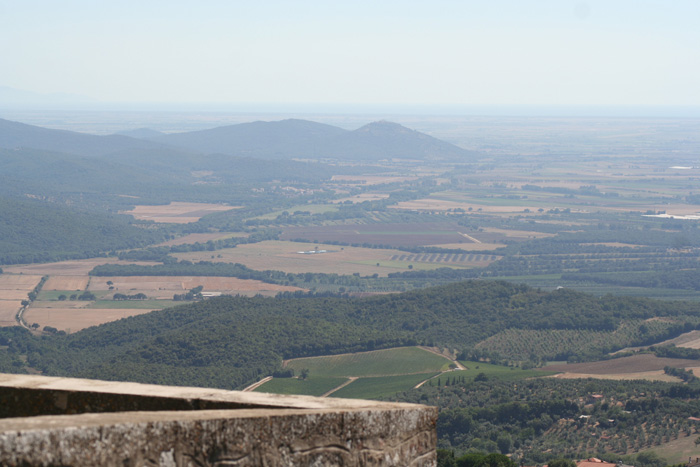
Podere Santa Pia, morning view on the Maremma from the northern terrace
|

[1] Source: Breve Guida Trekking Roccastrada | www.comune.roccastrada.gr.it
[2] Source: www.parcodeglietruschi.it |
|
|