
 |
|
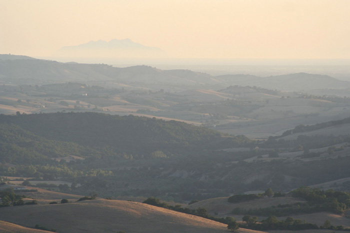
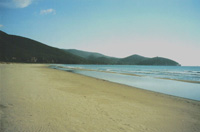
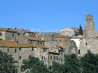
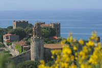
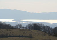
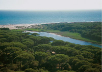
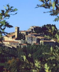
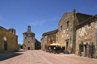
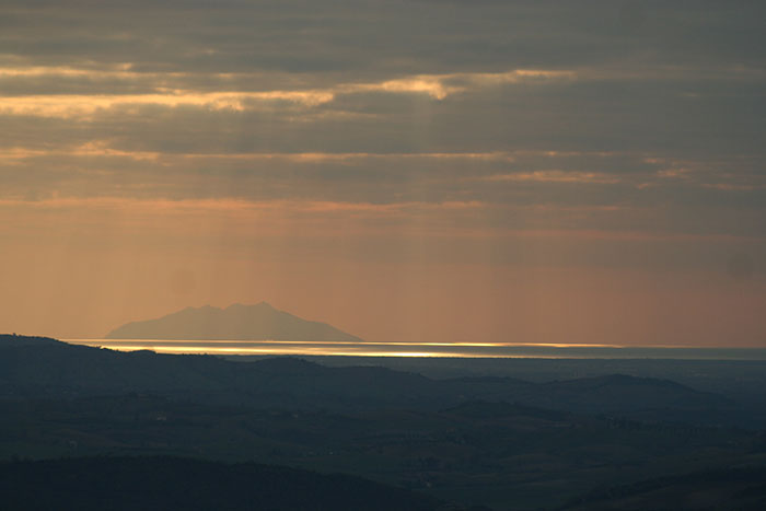
| I T | The Maremma, view from Castiglioncello Bandini, with a stunning view over the Maremma and Montecristo
|
|
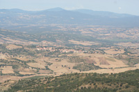
Endowed with significant natural and environmental resources, the Maremma is today one of the best tourist destinations in Italy, a region where ancient traditions have survived and Tuscan culture is preserved.
|
 |
Vincenzo Cabianca (1827–1902), Canale della Maremma toscana, 1862, olio su tela, Collezione privata
|
The Maremma can be divided into the Alta Maremma (upper or northern Maremma), and Bassa Maremma (lower or southern Maremma). The Alta Maremma exteds from Grosseto northwards to Cecina River just south of Livorno while the lower Maremma extends along the Albegna and Ombrone rivers down the coast to the Argentario and beyond.
|
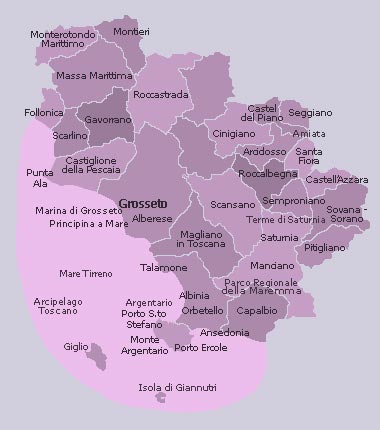 |
Alberese Albinia Ansedonia Arcidosso Caldana Campiglia Marittima Capalbio Castel del Piano Castell'Azzara Castiglione della Pescaia Cinigiano Follonica Gavorrano Giglio Giglio Campese Giglio Castello Giglio Porto Grosseto Isola di Giannutri Magliano in Toscana Manciano Marina di Grosseto Massa Marittima Monte Argentario Monterotondo Marittimo Montieri Orbetello Pitigliano Porto Ercole Porto Santo Stefano Principina a Mare Punta Ala Roccalbegna Roccastrada Santa Fiora Saturnia Scansano Scarlino Seggiano Semproniano Sovana Sorano Suvereto Talamone |
||
| Grosseto |
|||
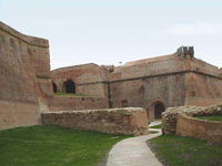
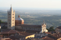
| Grosseto itself is a relatively recent city that developed during the mediaeval period on a site where Etruscan boats used to pass through the marshes. Grosseto was originally surrounded by a marine gulf that, over the centuries, was transformed into a large lagoon. Although it was damaged by bombing during the 2nd World War, the city has a lovely old town center enclosed by its marvelous Hexagonal Walls. The Fortezza Medicea, the northeast bulwark of the walls, is a site of particular fascination consisting of tunnels, magazines and gatehouses. Main sights of Grosseto are the Medicean Walls, the Duomo, Palazzo Aldobrandeschi, the Museo Archeologico e d'Arte della Maremma and the Roselle Archeological Area. |
 |
||
| Alberese |
|||
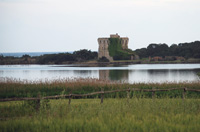
| The most famous part of the Maremma is the Parco Naturale della Maremma, otherwise known as the Parco dell'Uccellina after the name of the hills that comprise a large part of the park area. The entrances to the park are at Talamone and Alberese. The park is not open every day and it there is a limit on the number of visitors allowed in each day. The park stretches inland from the banks of the mouth of the river Ombrone. Although located within the Parco Naturale della Maremma, entry restrictions do not apply to Marina di Alberese, whose beach - though not as superb as that in the park, rates as one of the best in Tuscany. [read more] |
 |
||
| Albinia |
|||
Albinia, between Talamone and Monte Argentario, rises near the mouth of the Albenga river, from which it takes the name. The presence of the Tower of the Salines, near the mouth, shows that once salt was produced there. |
 |
||
| Ansedonia |
|||
| Ansedonia, situated on a small rocky promontory across the harbor from Porto Ercole, is a modern and luminous seaside resort facing the clear waters of the Gulf of Argentario. Rather than the rocks and pebbles that greet you on so many Italian beaches, Ansedonia offers soft, velvety sand. Ansedonia flourished in the 60's, with well-known architects of the time designing villas for the rich and famous, mostly in the mass-media circuit. Now, it is seen more as a retro relic of the past society. Above, in the archeological zone, lie the ruins of the Roman city of Cosa. The cliffs connect the long beach of Feniglia and the Taglia Etrusca, a magnificent channel cut through the rock by the Romans, designed to ensure the flux and reflux of water into the ancient port. [read more] |
|||
| Arcidosso |
|||
Situated up high, overlooking the beautiful territory below, Arcidosso definitely has an austere and magical atmosphere. |
 |
||
| Caldana |
|||
Caldana is a frazione of Gavorrano. Main sights are the Church of San Biagio and the Oratorio di Sant'Antonio da Padova.
|
 |
||
| Campiglia Marittima |
|||
| Campiglia Marittima maintains intact many aspects of the medieval town. The built-up area is dominated by the Castle, built perhaps between the 8th and 9th centuries but then rebuilt between the 12th and 13th centuries. A part of the medieval walls is still visible, and the North Gate and the Florentine (or St Anthony) Gate are original of the era, decorated with the stone coats of arms of Pisa, Florence, Campiglia and of the Gherardesca counts. [read more] |
|||
| Campagnatico |
|||
| Campagnatico is a characteristic medieval town located, located in the south of Valle del’Ombrone and only 32 kilometres from Casa Santa Pia. The town of Campagnatico boasts great importance and secular relevance and was even mentioned in Dante’s fable The Divine Comedy. |
 |
||
| Capalbio |
|||
| Extreme southern tip of the Maremma, on a low hill that is immersed in the Mediterranean scrub and just a few kilometres from the sea, Capalbio has a town plan that is in part still Medieval. Once a feud of the Aldobrands, of the Orsini and then of Siena it conserves 14th century walls within which there opens an imposing gate, and above the remains of the Aldobrand Fortress there rises a strong crenellated tower. Il Giardino dei Tarocchi (The Tarot Garden) is based on the slopes of Capalbio, surrounded by Mediterranean macchia, a timeless fascinating area. The garden is the main and most engaging work by Niki de Saint Phalle. [read more] |
 |
||
| Castel del Piano |
|||
| The history of Castel del Piano (current placename was already being used in 1198) was tied to the San Salvatore Abbey. During the XIII century it fell under the rule of the Aldobrandeschi counts of Santa Fiora. During the XIV century, together with Arcidosso, it became part of the territory of the Siena Republic. The medieval center maintains a harmonic series of parallel alleys interrupted by slopes, small squares (the evocative Piazzetta degli Ortaggi) and stairways. [read more] |
 |
||
| Castell'Azzara |
|||
Placed at the foot of Monte Civitella (which can be easily climbed starting from the Cave and by following the Anello paths) Castell’Azzara dominates the Paglia valley (in the distance the Apennines can be seen) and is the highest (about 800 m altitude) of the entire Amiata district. The ancient village is situated in the northern part of the Area dell’Tufo (Tuff Area) and is one of the most fascinating and interesting locations the Maremma.
|
 |
||
| Castiglione della Pescaia |
|||
| The modern city Castiglione della Pescaia grew around a medieval fortress and a large fishery, from which it got its designation. The medieval town is dominated by an Aragonese Castle. The medieval citade, l characterized by steep streets and buildings of the year 1300 and 1400, has completely been restored respecting the ancient town. In summer the four quarters of the town (Marina, Castello, Piazza and Portaccia) set up a Palio Marinaro. The Mariners Palio, a competion of boats with oars which takes place on the Bruna river, preceded a historic parade. [read more] Tuscany Beaches in Maremma | From Principina a Mare to Piombino |
 |
||
| Cinigiano |
|||
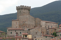
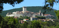
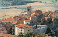
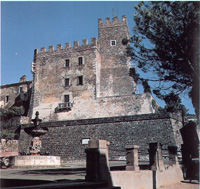
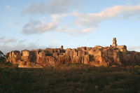
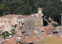
| Cinigiano rises on a hill west of the massif of Mount Amiata. It is a quiet village bordering the plains of Maremma. Cinigiano is shaped like a fortified village and preserves part of the walls and remains of the ancient fortress. The fraction of Castiglioncello Bandini, only 2,5 km away from Podere Santa Pia, belongs to the municipality of Cinigiano, at the foot of Poggio all'Olmo Nature Reserve, and is dominated by a splendid castle. Along the road leading to Monte Amiata, still within the territory of Cinigiano, one finds the ancient village of Monticello Amiata. The village was originally dominated by Monte Pinzutolo and is situated on a high hill, surrounded by a striking chestnut tree wood, and overlooks the valley of the Ombrone River. [read more] |
 |
||
| Follonica |
|||
Situated on the Gulf of Follonica (Golfo di Follonica), Follonica offers wonderful landscapes from Punta Ala in the south-east to Piombino in the Northwest and towards the sea, until Elba island. |
|
||
| Gavorrano |
|||
| The medieval center of Gavorrano rises on the side of Mount Calvo in the heart of the Grosseto Maremma with a splendid view of sea and hills. In 1898 here was discovered one of the largest mines of pyrite in Europe. Today, the mines are out of use and have been incorporated into the Gavorrano Naturalistic Mining Park; where you can find the delle Rocce Theatre, a large open-air space which is the venue for cultural events. [read more] |
 |
||
| Giglio |
|||
Giglio Island is located about 16 km west of Monte Argentario, 50 km south of Elba, in the southern corner of the Tuscan archipelago - a group of island that lie between Tuscany and Corsica. Giglio is the second biggest island of the Tuscan archipelago. There are 3 villages on Giglio: three villages: Giglio Porto, a small picturesque harbour, Giglio Castello, with its medieval fortification on top of a mountain, and Campese, on the western coast, the most popular tourist spot thanks to its wide beache. Lines to Isola del Giglio and Isola di Giannutri: Toremar Maregiglio |
 |
||
| Isola di Giannutri |
|||
| [read more] |
|||
| Magliano in Toscana |
|||
The municipality of Magliano consists of eight towns, Magliano in Toscana being the main one. Montiano and Pereta are the next largest towns, followed by the smaller localities of Sant'Andrea, Cupi, Collecchio, Poderone, and Alberese Scalo. |
 |
||
| Manciano | |||
| Manciano is found in the center of an area of greatest archaeological importance. The most important site in the comune is Saturnia, are the Cascate del Gorello, thermal springs dating to the Roman period. Manciano, situated on the top of a hill is dominated from the Rocca, today seat of the municipality. Hidden amongst the streets of the Manciano are some splendid treasures of the area’s ancient past, these monuments and buildings tell the history of the countryside and include the Church of San Leonardo, the main sacred building of the town and home to the works of two famous local artists, Peter Aldi and Paris Pascucci; the The Chiesa di San Leonardo , built outside the city walls. The densely built town centre of the frazione Montemerano, crowned by its leaning Torre di San Lorenzo, is contained within its ancient walls. [read more] |
 |
||
| Marina di Grosseto | |||
Marina di Grosseto is a frazione of Grosseto, and is renowned for the Mediterranean maquis shrubland of the Maremma and for its wide beaches on the Tyrrhenian Sea. |
 |
||
| Massa Marittima | |||
| Masa Marittima [read more] |
 |
||
| Montalcino | |||
| Montalcino has inextricably linked its name to that of its most famous product, Brunello, one of the most illustrious words in the international food-and-wine dictionary. Located just outside the <Maremme, Montalcino is dominated by the Rocca, a splendid example of a pentagonal-plan fortress, built after 1361 on the 13th-century wall structure and in an excellent state of preservation. The mediaeval nucleus of the town consists of the Piazza del Popolo with its 14th-century Palazzo dei Priori, flanked by a large open gallery with round arches and surmounted by a high side tower. [read more] |
 |
||
| Monte Amiata | |||
[read more] |
|||
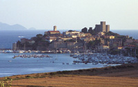
| Monte Argentario | |||
| Monte Argentario is one of the most famous spots in the Maremma and Tuscany. The promontory, which was originally an island, is characterized by a high, rocky coastline covered by a thick Mediterranean thatch, interrupted by olive groves and vineyards. It is now connected to the land by the Feniglia and Giannella sand bars, two strips of uninterrupted sandy beach and thick maritime pine. The sandy isthmuses are separated by the Laguna di Orbetello, an area protected by the WWF because it sits on one of the most important migratory routes and is one of the principal wintering sites for birds that nest in Europe. The serene tranquility of this lagoon contrasts with the high jagged Monte Argentario coast that hides small inlets in rocks that are inaccessible from the land. The Argentario and the Orbetello lagoon must be considered as a single ecosystem. The promontory is an ancient island, a relict of the so-called Tyrrhenis, a land in itself, now largely submerged, but of which the islands of the Tuscan archipelago were once also a part. The Argentario, culminating in Mount Telegrafo (635 m), is an irregular territory that rises steeply from the sea to the west, but slopes away more gently to the north. It is covered almost everywhere by Mediterranean scrub, particularly in the less accessible zones where the occasional rare specimen of the dwarf palm still survives [read more] |
 |
||
| Monterotondo Marittimo | |||
| Monterotondo Marittimo is a borderland, about 45 km northwest of Grosseto. Its territory marks the point of intersection of three different provinces: Grosseto, Pisa and Livorno. The wealth and much of the fascination of this area comes from the bowels of the earth. The emissions of water vapour and gas springing out from the depths provide energy indispensible for the geothermic exploitation so important to the economy. The geothermal plants near the town have acquired, with the passing of time, a character of their own integrated within this splendid natural environment. Monterotondo Marittimo rises in the valley extending along the right bank of the Milia torrent. Among the most important monuments to see in Monterotondo Marittimo we point out the Santuario della Madonna del Frassine, the remains of the Medieval fortifications and a geothermic park, Parco delle Biancane (Park of the Biancane) Nearby is the village of Frassine, known for the Sanctuary of Our Lady of Frassine. [read more] |
 |
||
| Montieri | |||
| Montieri is a quiet township immersed in the green woods and the Campo al Pera and del Piano nature parks. Montieri is situated on the slopes of the hillock of the same name. According to the testimony of the numerous tunnels in the area, the origins of the city were first Etruscan and then Roman. |
|||
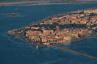
| Orbetello | |||
| Orbetello rises on a small peninsula, it is surrounded by the Eastern and Western lagoons and is divided by an artificial dam connecting Orbetello to the Argentario Promontory since 1841. The two lagoons are enclosed by two strips of land called Feniglia and Giannella tombolos. [read more] |
 |
||
| Pitigliano | |||
| Pitigliano is one of the most scenographic villages of Tuscany. Built on tufaceous ground, and bounded on three sides by three rivers (Lente, Meleta and Procchio) the village of Pitigliano is quite similar to Sorano. Pitigliano is known for its old Jewish ghetto and the Etruscan cave-tombse. The hamlet, already protected on three sides by cliffs, was protected on the fourth, and only accessible side, by a Medieval fortress which, like the one at Sorano, was remodeled by Antonio da Sangallo the Younger in the XV century. The village is dominated by the Orsini palace- fortress. Inside the palace there is a museum containing archeological finds and artworks from Statonia. The sixteenth century church of Santa Maria is at Capisotto. [read more] |
 |
||
| [read more] |
|||
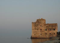
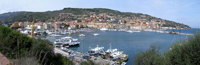
| Porto Santo Stefano | |||
| Porto Santo Stefano is the largest town on Monte Argentario and is the seat of public administration. It is situated in a picturesque bay with terracotta and cream-coloured houses populating the hillside. Connections leave from here for the islands of Giglio and Giannutri. The town also contains an important Mediterranean Aquarium with tanks that recreate the typical ecosystem of the Argentario coastline - the Silver Coast. There is an old part to Porto Santo Stefano but a lot of buildings had to be reconstructed after bombings in the Second World War. There is an impressive early 17th Century fortress to be visited that was built under the Spanish domination. [read more] |
|
||
| Porto Ercole | |||
Porto Ercole is located on the eastern coast of the Argentario. It is a charming seaside village that overlooks a bay protected by a small promontory. Porto Ercole is a picturesque small seaside town whose inhabitants are descended from Neapolitan fishermen. The town is set around a sheltered bay with a natural harbour. This picturesque 16th Century port is lined with bars and restaurants and is a smart and fashionable centre, altogether calmer and more low-key than the larger Porto Santo Stefano.
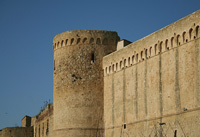
The old town, entered through an old Sienese gate and clock tower, is a maze of lanes and stairways that lead down to the port. It contains a plaque that claims that the famous painter Caravaggio died from malaria here in July 1610. Four fortresses, a testament to the period of Spanish domination, overlook the town and are well worth a visit. The main sights to visit in Porto Ercole include the 16th century Palazzo Consani, the old parish church of San Erasmo (where Caravaggio was buried in 1610) and the fortifications that date from the period of Spanish domination in the 16th century: Forte San Filippo, Forte Santa Caterina, Forte Stella and La Rocca; dominating the whole are the colossal fortifications, masterpieces of XVI century military architecture, that Philip II of Spain had built to defend the Stato dei Presidi. The latter's impressive fortifications are star-shaped and its high position affords sweeping views across to La Feniglia beach on one side and down to Porto Ercole's harbour on the other. The bay adjacent to Porto Ercole is Cala Galera where there is a modern tourist harbour home to several luxury boats and motor-yachts. |
|||
| Principina a Mare | |||
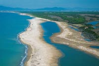
| Principina a Mare is a place mainly bathing fraction of the town of Grosseto. Principina a Mare is quite popular thanks to its proximity to the mouth of the River Ombrone and the Natural Park of Maremma. Principina a Mare is a nice seaside resort which enjoys a peaceful setting between the evergreen pine forest and the sandy beaches at the very heart of the Maremma. Near the northern the border of the Natural Reserve of the Maremma in the Uccellina hills, Principina a Mare is less than one hour by car away from Casa Santa Pia. [read more] Tuscany Beaches in Maremma | From Principina a Mare to Piombino |
 |
||
[read more] |
|||
| Punta Ala | |||
| An exceptional excursion from Follonica is Punta Ala, only a few minutes by car taking Collacchie Road towards South direction. Modern and well equipped residential village with a rational tourist port, Punta Ala rises on a promontory surrounded by the sea in a wonderful position. [read more] |
|||
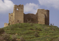
| Roccalbegna | |||
| Roccalbegna is one of most fascinating and extraordinary centres in the Monte Amiata territory. The small town takes its name from the numerous rocks which surround it and sits on the valley of the Albegna River, extremely close to the mountains Monte Labbro and Monte Amiata. Roccalbegna is about 24 kilometers far from Casa Santa Pia. The town is magical and interesting in every light, rich in ancient sites, historical palazzi and churches of great fascination and beauty. Roccalbegna is home to several notable fortifications, such as the Cassero Senese (built in the 13th century by the Aldobrandeschi, renovated in the 15th century) and the Rocca Aldobrandesca, located on the hill overlooking the town and the Albegna river (whence the town's name). Outside the town is the large Castello di Triana. There are many walks around Roccalbegna and Monte Amiata. The hamlet of Cana has also an Aldobrandeschi-built line of walls from the 13th century. [read more] |
 |
||
| Roccastrada | |||
| Roccastrada is a fascinating little town located in the province of Grosseto and is seen as one of the most charming and admired locations in the Maremman territory. Roccastrada is one of the widest Italian communes (28.000 hectares). Situated on the ridge of an intensively cultivated plateau, Roccastrada maintains the aspect of a medieval town, distinguished by the beautiful 13 Church of Saint Nicola in the old part of the town. The Town Hall, the Municipal Library and the Theatre of the Concordi are located in the 19 C new part of the town. Roccastrada, chief village of the district, was built around the 10th century, its main church, Chiesa di San Niccolò, was established around 1283. [read more] |
 |
||
| Santa Fiora | |||
| With its fascinating landscape and typical scenery, the town can be found at the feet of the massive Monte Amiata and is seen one of the most appreciated and beautiful locations in the territory, both for the great richness of its natural wonders, as for the fascination of its ancient structures and historic palazzi. With particularly ancient origins, the town is truly a treasure box of art and architecture of extraordinary beauty and profound interest. Santa Fiora became a center of primary importance during the XIII century as the family headquarters of the Aldobrandeschi counts and one of the main Tuscan Ghibelline centers. [read more] |
 |
||
| Saturnia | |||
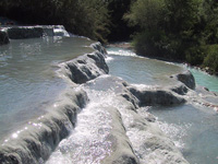
| Saturnia is well known for its thermal waters of sulfureous nature, springing in a valley at about 5 kilometers from the village, also forming a picturesque waterfall. Saturnia is a city of mysterious origins that, according to legend, was founded by the god Saturn. In the Middle Ages, it was completely destroyed by Siena because it was considered a center of conspirators. Today, its fame is linked to the nearby Saturnia Hot Springs, whose sulfurous waters gush all year round at a temperature of 37.5°. The springs are divided between two sites: the enchanting natural pools with waterfalls where access is free and you can always bath; the Terme di Saturnia Spa Resort complex, an oasis of relaxation with four open-air hot spring swimming pools, waterfalls, hydromassage and mud treatments. [read more] |
 |
||
| Scansano | |||
| Scansano is seen as one of the most beautiful and eminent centres in the Tuscan Maremma, a true gem of architecture, history and ancient culture. In the Parish church there is a very fine fired clay by Andrea della Robbia. In September an interesting folkloristic festival takes place: the Grape festival, in order to valorize wine production (Morellino di Scansano). [read more] |
|||
| Scarlino | |||
| The Scarlino area overlooks the sea and stretches from the Alma river to the first houses of Follonica, lying on a coast rich in cliffs and beaches. Scarlino Castle acted as a stronghold against enemies and pirates landing at nearby cities. Inside the Follonica Gulf, in the Bandite di Scarlino reserve, which is divided by a small promontory from Punta Ala, among a multitude of small caves, you will find Cala Violina. Cala Violina has been rewarded from Legambiente as one of the 11 most beautiful beaches of Italy. However Scarlino is also about archeology and history; some Etruscan finds were discovered between Scarlino and Puntone together with the remains of a Roman villa. [read more] |
 |
||
| Seggiano | |||
[read more] |
|||
| Semproniano | |||
| Semproniano stands on top of the hillocks which separate the valleys of the Albegna and Fiora rivers. The centre of Semproniano, with tight and tortuous roads, was developed in semicircles around the Aldobrandescan Fortress. There is not much left of the fortress, however the panoramic view at Mt. Amiata is worth the trip. The church of Santa Croce (XII century) rises next to the fortress and still holds a wooden crucifix of the XII century. Lower down, there is the pieve with bell tower with two sets of windows with one opening, dedicated to saints Vincent and Anastasio. At the entrance of the road leading to Fibbianello there is the church of the Madonna delle Grazie. From Semproniano the road goes almost consistently uphill to the fork between Petricci and Cellena, both routes go to Triana. The rests of Rocchette di Fazio dominate a hill of about 500 meters in the valley of the river Albegna, only 3 kms away from Semproniano. A few kilometres from Semproniano and on the road that leads to Grosseto by Roccalbegna, are Triana and the historic Castle Piccolomini overlooking the valley. Catabbio a small village in a panoramic setting. In the centre of the village we find the church of S. Anna, and in the Scalabrelli district, the ancient parish church of S. Lucia. [read more] |
 |
||
| Sorano | |||
| Sorano is located in the heart of the territory, in the Area del Tufo. The Massa Leopoldino towers over the houses, a high tufo cliff with a terrace at the top that dominates the village. In the village one can see the Collegiate of St. Niccolo church and what remains of the count's palace. [read more] |
 |
||
| Sovana | |||
| Located in a magical and enchanting place, Sovana is a wonderful village in the heart of the Maremma, rising over the stunning panoramas of the Area del Tufo. In the central square are the fourteenth century Palazzo Pretorio, the Loggetta del Capitano, Palazzo Bourbon del Monte, the romanesque church of St. Maria with paintings of the Sienese School and a pre-romanesque ciborium. At the bottom of the village there is the Duomo, in romanesque style and a crypt of the 8th century. [read more] |
 |
||
| Suvereto | |||
| Suvereto is an evocative medieval village with its circuit of walls still intact, situated but a short distance from the Etruscan city of Populonia and about 11 km northeast of Campiglia Marittima. This small village in the Maremma experienced its golden age during the 13th century. [read more] |
|||
| Talamone | |||
| Talamone stands on a little promontory, dominated by an ancient Sienese fortress, to the extreme south of the Monti dell'Uccellina. Talamone originally stood on the Talamonaccio hill and was only moved to its present site in medieval times. In antiquity it was an Etruscan port.
Near to Talamone is the spa of Osa. Here, a spring of suphureous water with a temperature of 32°C is exploited for the therapeutic purposes. |
 |
||
| The whole territory of the Maremma is one of the few natural remaining jewels in Tuscany that hasn’t been still completely discovered. Nowadays, the relative lack of concentrated cultivation in the most uneven soil of the Maremma has induced to preserve its rich intrinsic wildlife. The area is home to several nature reserves (for a total of almost 40,000 hectares), offering visitors endless opportunities to learn about its faunistic and botanic habitats and species, insects, flowers, the light and the vistas of a land capable of generating powerful emotions. The region includes thirteen Nature Reserves and other additional protected places like: Reserves of Repopulation, Biogenetics, Protection and Comprehensive Protection, as well as several wild flora and fauna oasis, which is equal to 40,000 hectares, more or less, of nature reserves. The Maremma territory develops along the Tyrrhenian coasts from the north of Grosseto to the southern border with the Lazio region, comprising the Maremma Natural Park and the Monte Argentario headland. The Maremma Natural Park covers the natural reserve of the Monti dell’Ucellina, which extends parallel to the shoreline from Principina a Mare to Talamone. This natural park has been one of the earliest protected areas established in Italy. |
|||
| The Maremma Park | Parco Naturale della Maremma |
|||
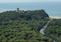
| Also known as Uccellina Park, this protected area set up in 1975 consists of the stretch of Tyrrhenian coast between Principina a Mare and Talamone and its interior as far as Alberese and the Aurelia main road, which is crossed by the Uccellina Mountains. Itineraries of varying degrees of difficulty have been prepared for visitors, some of which require you to be accompanied by a guide. The various habitats in the park follow on from one another in splendid harmony: the northern tip is occupied by a vast wetland area bordered by the Ombrone, which gives way, south of the river, to a monumental pine forest of 600 hectares created at the behest of Leopold II of Lorraine to protect the cultivated lands in the immediate vicinity. The Uccellina Mountains, which reach an altitude of 417 m, are covered on the side facing the coast with thick Mediterranean scrub, alternating on the other side with deciduous tree woods. The fauna in the park is extremely varied, especially as regards both non-migratory and migratory birds. [read more] |
 |
||
| Diaccia Botrona |
|||
| The Diaccia Botrona extends over a thousand hectares of reeds and brackish waters and is what remains of the old Lago Prile, even today wrapped in a aura of myth. In the midst rises the Casa Rossa, a construction dating back to the late ‘700 designed by Leonardo Ximenes, the mathematician and engineer who developed a sophisticated locks system for reclamation of the so-called “swamp”. This is where the Museo Multimediale stands today. [read more] Multimedia museum of Diaccia Botrona The Museum is situated in the Casa Rossa or Casa Ximenes (Red House or Ximenes House) which is 1 km circa from the old town of Castiglione. The building, which was built in the 1767 by the engineer Leonardo Ximenes and has been recently restored, was commissioned by the grand duke of Lorrain Pietro Leopoldo, who decided to start the ambitious project of reclaiming the Maremma marshes beginning from Castiglione. The Museum shows the nature reserve of Diaccia Botrona, a large, wet area of more than a thousand hectares close to the large Pinewood of Tombolo. This pinewood is what remains of the ancient Prile lake, which was reclaimed in the 19TH century. The nature park Diaccia Boltrona is characterized by a rare and important ecosystem where an incredible amount of animal and plant micro-organisms lives. Around 200 species of birds, among which the egret, the marsh harrier and the kite live in the typical marsh vegetation. |
 |
||
| WWF Oases |
|||
| Within the Grosseto province, there are areas which fall within WWF conservation project: Bosco Rocconi and affiliated Oasis of Capra Matilda (Roccalbegna/Semproniano), Lago di Burano (Capalbio), Laguna di Orbetello, San Felice affiliated Oasis (Marina di Grosseto). [read more] The San Felice Oasis is located in the strip of wetlands along the Tyrrhenian coast in the Tombolo pinewood, a protected area of the Diaccia-Botrona Nature Reserve run by the Province of Grosseto. The San Felice Oasis consists essentially of four different habitats (five, if you include the public beach), in part completely natural, in part shaped by centuries of labour, especially with the reclamation works initiated in the 19th century by the Lorraine grand dukes of Tuscany. [read more] |
 Lago di Burano, Torre di Biranaccio |
||
| THE TUSCAN ARCHIPELAGO | |||
| Seven main islands from Gorgona, the northernmost and the smallest, to Giannutri the southernmost. In the middle there is Capraia, Elba, Pianosa, Montecristo and Giglio. [read more] |
|||
| THE AMIATA MOUNTAIN FAUNISTIC PARK | |||
| The Park, managed by the Comunità Montana covers 120 hectares and is considered a true ‘Wild Park’ by experts, based on the German model. Amongst the animal species to be found: deer, fallow deer, moufflons, and some species of cha mois and roe deer; it is also possible to see the Apennine wolf. [read more] |
|||
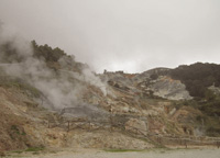
| THE PARK OF THE BIANCANE | |||
| Close to the centre of Monterotondo Marittimo there is a special geothermal park where certain special phenomena are seen, including the smoke holes. It owes its name to the white colour of the rocks that characterizes the entire landscape, and which is derived from the chemical reactions caused by the geothermal nature of the territory. [read more] |
|
||
| Park of Montioni Comuni of Follonica (GR) Suvereto, Campiglia Marittima and Piombino (LI) |
|||
| Instituted in 1998 the Park of Montioni is situated between the river basins of the Cornia river (to North) and of the Pecora river (to South) and is constituted mostly from boscate hills of low altitude (308 the maximum height m. Poggio al Chiecco). It has an extension of 7000 hectares. The Park of Montioni is a a true island of green hills set around the hamlet of the same name. The slopes of Monte Calvi and the area around Montioni are almost entirely covered by woodland and scrub . [read more] |
|||
 |
|||
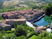
Podere Santa Pia, situated in a particularly scenic valley in the heart of the Maremma,
|
|||
Podere Santa Pia, a formal cloister in the Tuscan Maremma is situated on the outskirts of Castiglioncello Bandini and dominates one of the most beautiful setting that nature can offer: the Tuscan countryside. Holiday homes in the Tuscan Maremma | Holiday home Podere Santa Pia |
|||
| There are eight DOC and three wine roads in a territory where vitiviniculture has always been an art starting in the Etruscan area. Morellino di Scansano, Ansonica (Costa dell’Argentario), Bianco di Pitigliano, Capalbio, Sovana and Parrina are the DOC wines of the southern part of the province, “Colli di Maremma” wine road; “Monteregio di Massa Marittima” and Montecucco are the DOC in the southern areas with roads by the same name and wine-making companies. | |||
 |
|||
Podere Santa Pia, garden view in April |
|||
| Publications - Agency for Tourism Maremma | |||
Farinelli, Roberto Francovich, Riccardo (a cura di) , Guida alla Maremma medievale. Itinerari di archeologia nella provincia di Grosseto, Nuova Immagine Editrice, Siena, 2000, Isbn: 88-7145-170-1
|
|||
A selection of videos concerning Podere Santa Pia or cultural events in the Tuscan Maremma. Honey is produced all over Tuscany: in the Maremma region bees are a natural part of this environment. |
 The first hive at Podere Santa Pia |
||
 Porto Santo Stefano
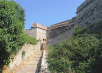 Porto Ercole - Forte Filippo