
 |
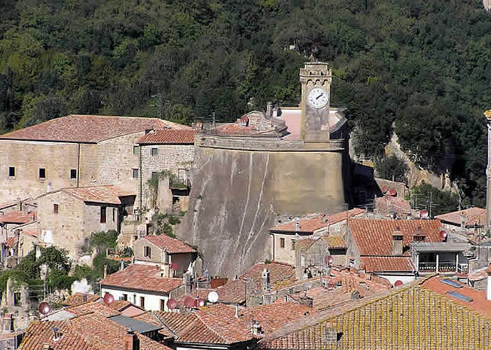
Sorano, Sasso Leopoldino |
Sorano |
Sorano dates back to the Etruscan era and its surroundings are rich in historical and artistic memories of this glorious past. The various remains visible near Sorano date back to different historical periods. Some fortifications, such as the Castle of Montorio, the Fortress of Castell'Ottieri and the castle of Montebuono hail from the Middle Ages. However, the most interesting place to visit is the Archaeological Park of this Tuff Town, where the most interesting Etruscan remains are preserved along with some caves which were once used as houses by pre-Etruscan civilizations. This is really an archaeological area which must not be missed. |
||||
| Sasso Leopoldino As its name clearly indicates, this castle was built in the XVIII century when the Lorraine grand dukes ruled the area. It is located north of the tufaceous spur on which the village stands and, together with the fortress, dominates the entire surrounding settlement below. The reason that the Lorraine rulers fortified it with a scarp wall, transforming this enormous mass of tufa in the center of the village into a fortress is unclear. Perhaps they felt it necessary to improve the defenses of Sorano by building a compound complete with a crenellated tower that held the town bell. Whatever, the reason, it proved useless if the outer defenses had fallen and in fact it created a hazard for the houses below due to the frequent landslides that plagued the old village. Later it was flattened and transformed into the vast piazza from which we can enjoy a splendid view. |
||||
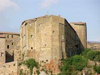
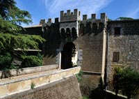
Fortezza Orsini rises on a tufaceous spur to defend the village below on the only side from which it is easily accessible. Sorano’s Orsini Castle is one of the most impressive pieces of military architecture in all of Tuscany and one of the region’s most important strongholds. For a long time the Sorano Fortress defended the borders of Southern Tuscany as well as the entire country. Its position was reinforced by its ancient wall and the drawbridge which could be closed to keep invaders out. |
|
|||
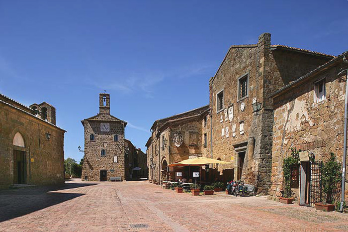
The church of San Niccolò The old collegiate and archipresbyterate church stands in the middle of the Medieval village of Sorano. It was built by Sienese craftsmen between 1290 and 1300, under orders from Countess Margherita di Monfort. The original structure is no longer recognizable: many nineteenth century modifications completely altered its original Romanesque appearance. Inside the church we can see a beautiful, XVII century wooden crucifix that Cosimo III de’ Medici gave to the collegiate of Sorano, an interesting ciborium of dark stone and a Renaissance canvas by Raffaello Vanni. Heavy Baroque stuccowork has transformed the original surfaces which probably consisted of rows of tufa alternating with travertine. It is believed that Margherita’s hasty departure for the Maremma is the reason that the church has no frescoes and not even a holy water stoup that date from its construction. The church is dedicated to Saint Nicholas, the miracle worker, Bishop of Myra who died in 326. |
||||
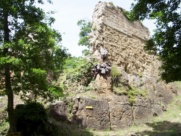
In the territory of Sorano, there are two interesting, although different, examples of fortified constructions: the Montorio Castle and the fortress of the Castell’Ottieri. |
||||
Montorio stands in the middle of the Stridolone river valley. We can admire the remains of a small Medieval castle which in 1356 became a protectorate of the Republic of Siena. Once its strategic function was no longer necessary, it was transformed in the modern era into a large agricultural estate and underwent various renovations. |
|
|||
In olden times this village San Quirico was known as San Quirichino to distinguish it from San Quirico d’Orcia. It stands at an altitude of 507 meters a.s.l. and is the most densely populated fraction of the municipality of Sorano.
|
|
|||
 |
 |
 |
||
| Entrance of one of the caves | Rupestre di Vitozza, il secondo castello | Vitozza, il primo castello
|
||
Elmo was a sub-fief that the Grand Duke Cosimo III erected in the county with the title Ermo al vivo, and granted to the nephews of the bishop of Montepulciano. Elmo is the home of the Abbey of Montecavallo that hosted the future Pope Gregory VII. Just a few kilometers from Elmo is the hamlet, or fraction of Montebuono and the castle that dates from the early XIV century when it came under the rule of Siena. Explore Maremma Walking Festival 2017 | Sorano | Via Cava di San Rocco
Itinerary from Sorano, to the ancient city of Vitozza and San Quirico | 9 km | 2 hours | gpx
Comune Sorano
|
||||
|
||||
 |
||||
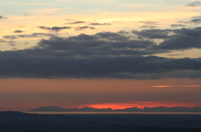
View from Podere Santa Pia on the Tuscan Maremma, all the way up to Montecristo and Corsica
|
||||
| Sovana |
||||
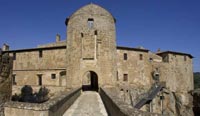
 Montorio Castle
 |
|
Sovana, main square with Palazzetto dell' Archivio and the Chiesa di S.Maria |
|
| Sovana was once an important Etruscan city, but enjoyed its period of greatest splendor under the Aldobrandeschi. The prosperity the city achieved in the XII-XIII centuries under the Aldobrandeschi counts is carved into the Medieval remains of the town center. Here we can see the ruins of the Aldobrandeschi Rocca that predate the inhabited portion of the town: it is a XIII century structure that was restored in 1573 and then demolished in the XVII century. The principal buildings flank the main street: Casa Busatti, the church of Santa Maria and the cathedral. Just a short distance from the village we can tour an important Etruscan necropolis that was discovered by Ainsley in 1843. The Church of Santa Maria is a fourteenth century edifice built on an almost square plan. It is divided into three naves by broad arches supported by four octagonal pilasters, and has a trussed roof. The entrance is on the right side of the building and it was created when the main entrance was closed off due to the construction of the Palazzo Bourbon del Monte (XVI century). The original bell tower, that was destroyed some time after the XVII century, was replaced by a bell gable. The church houses one of the oldest and most complete pre-Romanesque ciboria in Tuscany. It is made of travertine and can be dated between the VIII and IX centuries. The Corinthian capitals support a baldachin that is entirely decorated with typically High Medieval motifs: bunches of grapes, doves, peacocks, leaves, etc. The church also contains some very fine fifteenth century frescoes that have been attributed to a follower of Andrea di Niccolò. Now isolated from the rest of the town, the cathedral rises on the western strip of the block of tuff dominating the valley of the necropolis. It exhibits various styles - Lombard, Romanesque, Gothic - in correspondence with the different periods in which it was constructed. The Duomo was built on the foundations of a pre-existing building at the end of the 11th century under the watchful eye of Pope Gregorio VII. Today the cathedral is one of the most artistically significant buildings in the territory with its tenth century octagonal dome and rich decorations created with tiles taken from the original church. Under the cathedral’s apse is a 7th century crypt. There are exquisite sculptures dating to this epoch on cornices and capitals, especially those of the portal and of the lunette over the main entranceway. When the bishop’s seat was moved to Pitigliano, many of the artworks were moved to the new cathedral. Currently the Sovana cathedral houses the tomb of St Massimiliano and his burial urn, as well as a baptismal font, which dates back to 1434 and was shaped from traventine rock and decorated with sacred symbols and precious jewel figurines. The area of Sorano and Pitigliano is located at the center of a defensive line which connects the Grosseto coast to Orvieto and forms the boundary between Tuscany and Lazio. This leads to the belief that the fortresses in the area were the product of the Medici Grand Duchy’s defense strategies. |
|||
| Sovana, Castell'Ottieri, Montorio and San Giovanni delle Contee belong to the comune Sorano. |
|||
| There are several tracks, the ancient Vie Cave, that lead to the near archaeological sites, like San Rocco (an Etruscan necropolis), with its beautiful view of Sorano. The ruins of Vitozza, a rare and amazing town carved out of rock, constituted by about 200 caves, inhabited until 1700, with a beautiful roman columbarium and the remains of the walls of the castle and the church. Vitozza, with around two hundred caves, it was one of the largest cave settlements in Italy. Parco Archeologico Città del Tufo | The Archaeological Park of Tufo between Sorano, Pitigliano, Sovana, was inaugurated in 1998 and it spreads across a vast area, heavily marked by the erosive action of the rivers and, hence, by a striking, delightful landscape, displaying a wealth of deep canyons, opening out onto the tableland. The Archaeological Park proposes an itinerary that fully achieves a combination of nature, landscape and monuments from the Etruscan and Medieval civilisation. The park encompasses the city of Sovana, with its most relevant monuments, the hollowed out roads and necropolises that developed around them, and the celebrated Tomba Ildebranda, Tomba della Sirena, Tomba Pola, Tomba Pisa and Tomba del Sileno. The Rupestrian settlement of San Rocco, with its historic proof of the Middle Ages, stands in the immediate vicinity of Sorano and is panoramically situated above the Lente River. From San Rocco, one can reach Sorano and tour the Orsini Fortress that houses the Museum of the Middle Ages and Renaissance. The visit to the park is concluded with a visit to the Rupestrian village of Vitozza. This village is set in immediate proximity to the district of San Quirico of Sorano, with its two hundred grottos. Address Parco Archeologico "Città del Tufo", Palazzo Pretorio, Piazza Pretorio, 12/a - Sovana - Sorano (GR) Opening hours From two weeks before Easter to 2 November 10.00-13.00; 16.00-19.00 26 December - 6 January 10.00-13.00; 14.00-17.00 During the rest of the year 10.00-13.00 Opening of Etruscan Necropolis of Sovana weeks before Easter to 2 November 10.00-19.00 26 December - 6 January 10.00-17.00 Winter visits by prior arrangement Tickets: Free |
|||
| From Pitigliano to Sovana along the vie cave |
|||
This attractive itinerary, starting from the village of Pitigliano and winding along a track through Etruscan vie cave and hilly sections, brings us to the centre of Sovana. |
|||
Sorano and the rock settlement of Vitozza |
|||
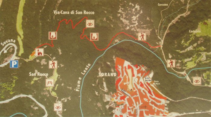
| Walking through the Etruscan necropolis of Sorano | From Sorano to Vitozza, along the vie cave and the Necropolis of Poggio Felceto (download pdf) This attractive itinerary, starting from the village of Sorano, and winding along a track through Etruscan vie cave and hilly sections, brings us to the Rupestrian settlement of Vitozza and the town of San Quirico. This brief itinerary begins on an asphalted road and continues towards the Valley of the Lente River and the rocky settlement of Vitozza, then turns north towards the modern residential centre of San Quirico. It is possible to deviate from the itinerary towards the Selava del Lamone and Ischia di Castro in the province of Viterbo. Coming from the direction of Sovana, two kilometres from the village of Sorano, we meet the well-marked sign to the necropolis of San Rocco and its church. We cross the bridge that brings us to the indicated area, where we can admire the necropolis and the splendid balcony that looks over the village and, right behind the church, we descend the via cava di San Rocco, that leads to the bottom of the valley below Sorano. Sovana - Sorano, along the Etruscan vie cave | 13,37 km | 2 h 40 min | gpx Escursione per le vie cave degli Etruschi, da Sovana a San Rocco e Sorano | 15,89 km | 3 h 10 min | gpx |
 Tomba Ildebranda Tomba Ildebranda |
||
 |
|||
On the road from Sovana to Sorano, the Via Cava di San Rocco (and Parking) is on the left, two km before entering Sorano |
|||
| There is indeed a broad range of dwellings and rooms carved into the tufa rock in the area around Sorano. Often a single underground room served several different purposes over the centuries, like the columbaria. During some periods, such as the High Middle Ages, they were used mainly as housing and in others the underground spaces were used as annexes - stables and the “famous” cellars (that provided excellent storage for the local wines), and as necropolis. |
|||
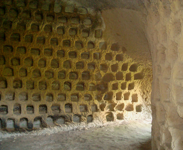
The colombari |
|||
| The columbaria are one of the typical features of the Sorano area. They are to be found in the lowest part of the village and in the surrounding crags (Columbarie, Rocchette, Castelvecchio and San Rocco). Some consist of rough, uneven niches, but others (at Colombarie) are quite elegant and refined and contemporaries of those built outside Rome during the Augustan age.The collapsing of the tufa makes it impossible to enter many of them, but even in ancient times some could only be accessed via temporary ladders. The tufa ridge near Sorano, which until today has been impossible to reach because of the provincial road built in the nineteen thirties, features an exceptional number of colombari or dovecotes. They were studied by Ranuccio Bianchi-Bandinelli in 1929, who compared their construction characteristics to those of the dovecotes built in Rome during the Augustan age (1st century A.D.) and were re-used from the early Middle Ages onwards to breed doves. Their highly developed architecture (in some cases access to the quadrangular rooms, the walls of which are completely occupied by the small cells, is through a small vestibule) and state of preservation make them unique, even when they are compared to the numerous specimens that can be found throughout the area of Sorano. In 1929, Ranuccio Bianchi Bandinelli dedicated a monographic study to the Necropolis of Poggio Felceto and the Ildebranda Tomb, also carrying out the graphic reconstruction of the alzato (raised part), which corresponded to the characteristics of the Etrusco-Italic temple of the Hellenistic Age as described by Vitruvio.[1] |
|||
|
|||
 |
|||
Columbari. the characteristic caves in the cliffs |
|||
| The debate over the use of these columbaria is still open. There are those who maintain that they were used to raise and shelter pigeons, and others who view them as an example of the “Roman burial columbaria”. One very interesting hypothesis takes their location into account. The columbaria are located in tufaceous walls overlooking the River Lente. This river is full of fish, and nearby are woods and pastures so it seems to have been the ideal location for establishing a village that predated the advent of the Etruscans. The village was linked to the land below via a rope ladder that was pulled in every night to protect the inhabitants from enemy raids. The natural position offered the people safety and tranquility. The Etruscans probably used these early cave dwellings for burial purposes because there would have been no reason or advantage in building them in such a difficult position. In fact, the Etruscans generally built their necropolis in easily accessible locations (such at the site at San Rocco). After the Etruscans it is possible that the Romans used them to shelter thousands of carrier pigeons – a business that flourished during their era – but this is only one of many hypotheses. |
|||
|
|||