|
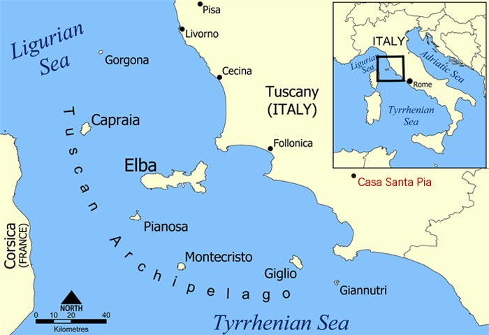
| The Tuscan archipelago is a chain of islands between the Ligurian Sea and Tyrrhenian Sea, west of Tuscany. The archipelago contains the islands of Elba (the largest island of the group), Pianosa, Capraia, Montecristo, Giglio, Gorgona and Giannutri, all of which are protected as part of the Tuscan Archipelago National Park. According to legend, the Tuscan Archipelago originated from a jewel that slipped off Venus’s neck, the goddess of beauty and love, and fell into the Tyrrhenian Sea. The Isles known as Giglio and Giannutri in particular are not to be missed. Isola del Giglio is not very big but its three villages, Giglio Porto, Campese and Il Castello (the castle), are inhabited all year round. Elba is the largest of the islands in the Tuscan Archipelago, and the third largest of the Italian islands. Elba is only 10 km away from the Italian mainland, and is within easy reach of Podere Santa Pia. The best seasons to visit the islands of the Tuscan archipelago are spring and autumn. The island becomes more animated during the Summer months when thousands of visitors arrive to enjoy its crystal clean sea, the little harbours and creeks, and the beach. An excellent moment to visit Giglio is on September 15, when the island celebrates Saint Momiliano, its Patron Saint. |
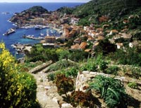
 Giglio Castello, Spiaggia Aranella Giglio Castello, Spiaggia Aranella |
|
 |
||
The islands of Tuscan Archipelago played a crucial role in ancient navigation over Western Mediterranean: they helped ancient sailors to calculate their position, they were involved in commercial exchanges and offered safe places to stop and recover, as well as providing food and shipping supplies. For those who wish to have a less touristy experience, the isle of Giannutri is a better destination. Even though it is quite close to the Island of Giglio, it is definitely a place for those who wish to "get away from it all" for the day and plunge into history and nature. Besides its fantastic (and protected) coastline, where it is possible to dock only in certain places, Giannutri has been inhabited for centuries and is home to one of the main archaeological sites in Tuscany: the ruins of the Roman Villa of the Domizi Enobarbi (first half of the 1st century AD). For those who wish to explore the many islands of the Tuscan Arcipelago, it is possible to participate in one of the mini-cruises advertised on these websites:
Itineraries in this area of the Maremma, information about the archaeological sites of the Maremma and about the villages and towns of this part of Tuscany can be found in the Costa d'Argento brochure by the Maremma Tourism Office. Other itineraries and suggestions for day trips in the Maremma are also available on the website of the Province Grosseto and on the website of the Proloco Association of Marina di Grosseto.
|
||
|
||
Nature and environment
|
||
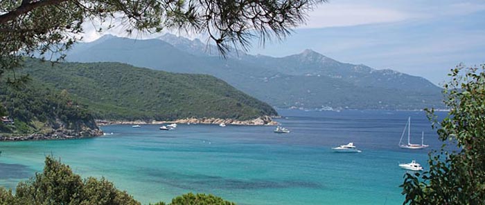
| Isola d'Elba |
|||
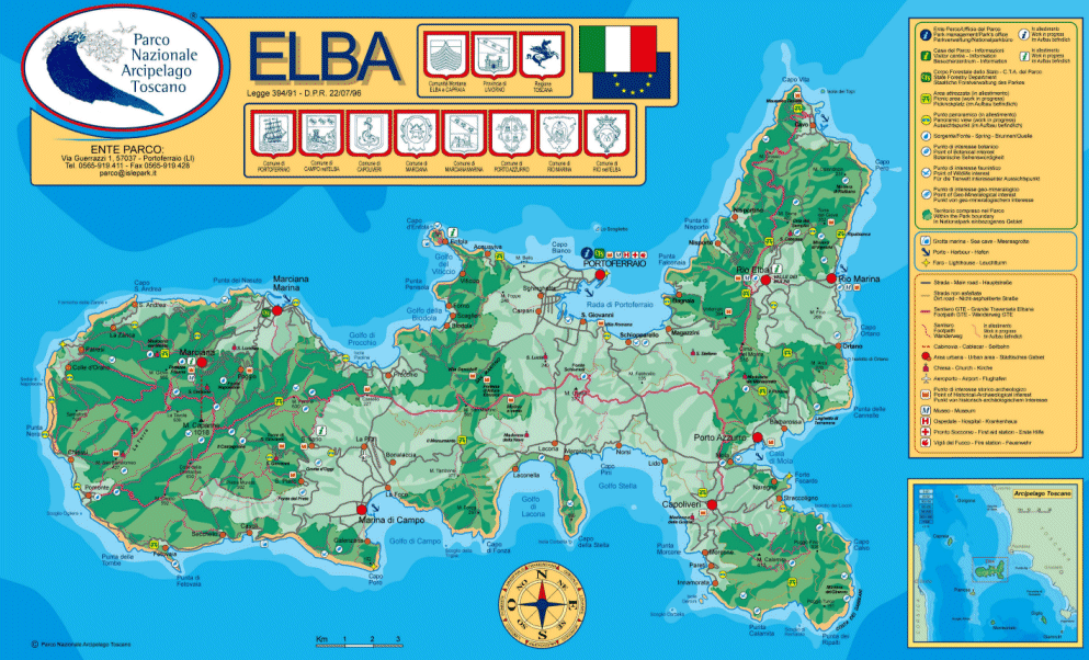
| The Island of Elba is the third largest Italian island after Sicily and Sardinia and is the largest in the Tuscan Archipelago. It has recently become part of the Tuscan Archipelago's National Park together with the islands of Pianosa, Capraia, Montecristo, Giglio and Giannutri. Elba has a coastline of 147 km: its main mountain (Monte Capanne) is 1019 metres high, accessed via pathways or by a panoramic cable car. Already in acient times Elba's destiny was always deternined by two factors: its strategic position and the richness of its mineral resources. Due to these characteristics, it was often the object of conquest for the various powers along the Mediterranean. For the Etruscans and the Romans Elba represented an inexhaustible source of riches and the iron from Elba contributed to the prospering of their civilazation. During the Medieval period Elba was dominated by Pisa. The remains of some important and striking defensive structures testify to the importance of possessing the island. The AppIani Lordship followed, as did the attentions of Cosimo de Medici, who built "Cosmopoli" on top of the ruins of the Roman city of Fabricia - now the capital Portoferraio - and had it surrounded with the impressive walls that saved the inhabitans from many pirate raids. The Spaniads settled in Porto Azzurro and they too made sure to construct defenses on their territory - the imposing San Giacomo Fort still dominates the pleasant landscape. In the more recent history, the period that made this island famous and placed it on the world map was the brief exile of Napoleon, who stayed here for 10 month prior to his 100 days adventure which was finished in Waterloo. Bonaparte left a significant mark of his short reign: Important reforms and buildings like his Townhouse Villa dei Mulini in Portoferraio and his impressing summerresidence San Martino - which are now museums and can be visited. Eight picturesque little towns (Portoferraio, Marciana, Marciana Marina, Campo nell'Elba, Capoliveri, Porto Azzurro, Rio nel'Elba and Rio Marina) are scattered about a rugged land, hilly and mountainous for the most part, crowned by a three thousand foot peak called Monte Capanne. Portoferraio (N) is the biggest place. Other villages at the sea are Cavo (NE), Rio Marina (E), Porto Azzurro (E), Lacona (S), Marina di Campo (S), Cavoli (S), Seccheto (S), Fetovaia (S), Pomonte (W), Chiessi (W), St. Andrea (NW), Marciana Marina (N) and Procchio (N). Main Harbors and Marinas are in Portoferraio, Porto Azzurro and Marciana Marina.
|
 |
||
 |
|||
|
|||
|
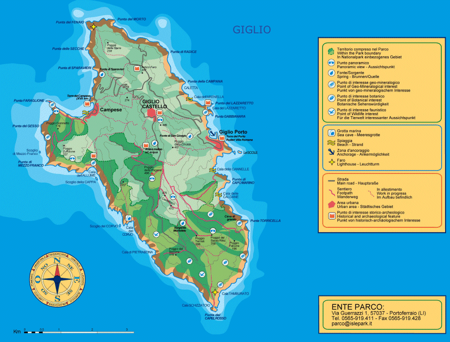
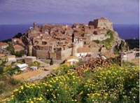
Isola del Giglio |
|||
Giglio is the second biggest island of the Tuscan archipelago. There are 3 villages on Giglio: Giglio Porto on the East side, Giglio Campese in the North and Giglio Castello on the hill. A small harbor is at Giglio Porto, hopeless full in the summer months. Already inhabited in the Stone Age, and subsequently used by the Etruscans, possibly as a military outpost, Giglio went through one of its most important period under Roman rule, when the island became a commercial junction of maritime trade between the various Provinces. The importance of the island is highlighted by the recovery of numerous Roman shipwrecks. The islands period of glory is connected to the presence of the Roman aristocrat family Domizi Enobarbi that made it a fundamental marine junction for trade between the different provinces within the empire. Trekking and Scuba Diving on Isola del Giglio Lines to Isola del Giglio and Isola di Giannutri: Toremar Maregiglio Orari Navi/Ferry schedules/Fahrpläne: P.S.Stefano Giglio | www.isoladelgiglio.it |
|
||
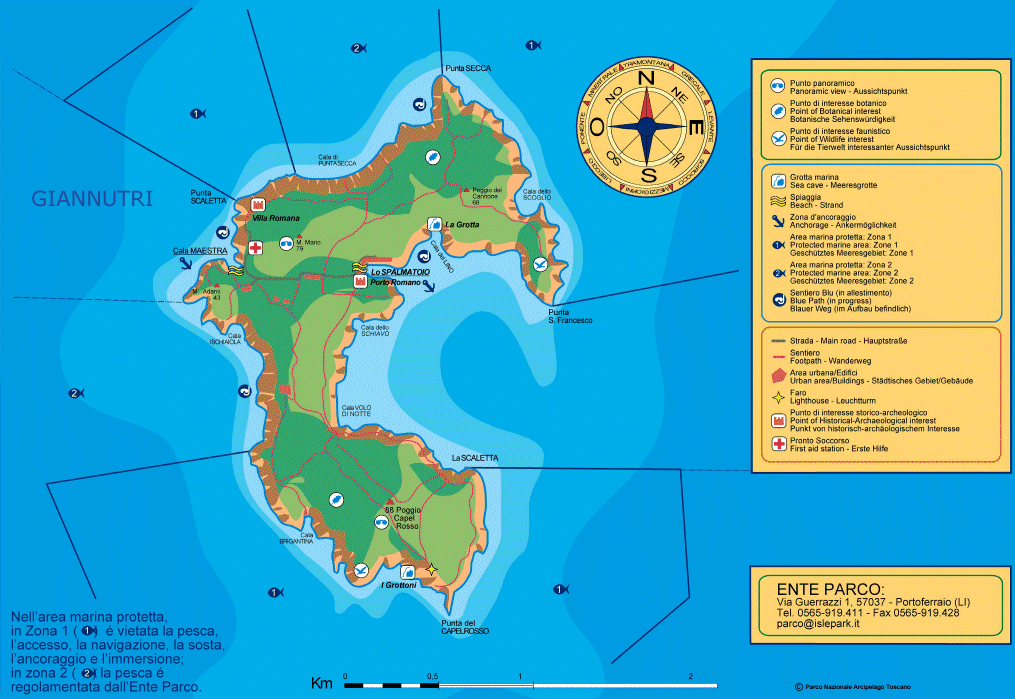
Giannutri |
|||
| Giannutri is the island most in the South of the Tuscan archipelago. Besides its fantastic (and protected) coastline, where it is possible to dock only in certain places, Giannutri has been inhabited for centuries and is home to one of the main archaeological sites in Tuscany: the ruins of the Roman Villa of the Domizi Enobarbi (first half of the 1st century AD). Giannutri is a private island. There is a small bungalow village on it. The big bay in the middle is a good anchoring site with winds from W to E. Anchoring depth about 20-30 meters even next to the coast. The rest of the island is under natural protection and off limits between 1 nautical mile. |
 |
||
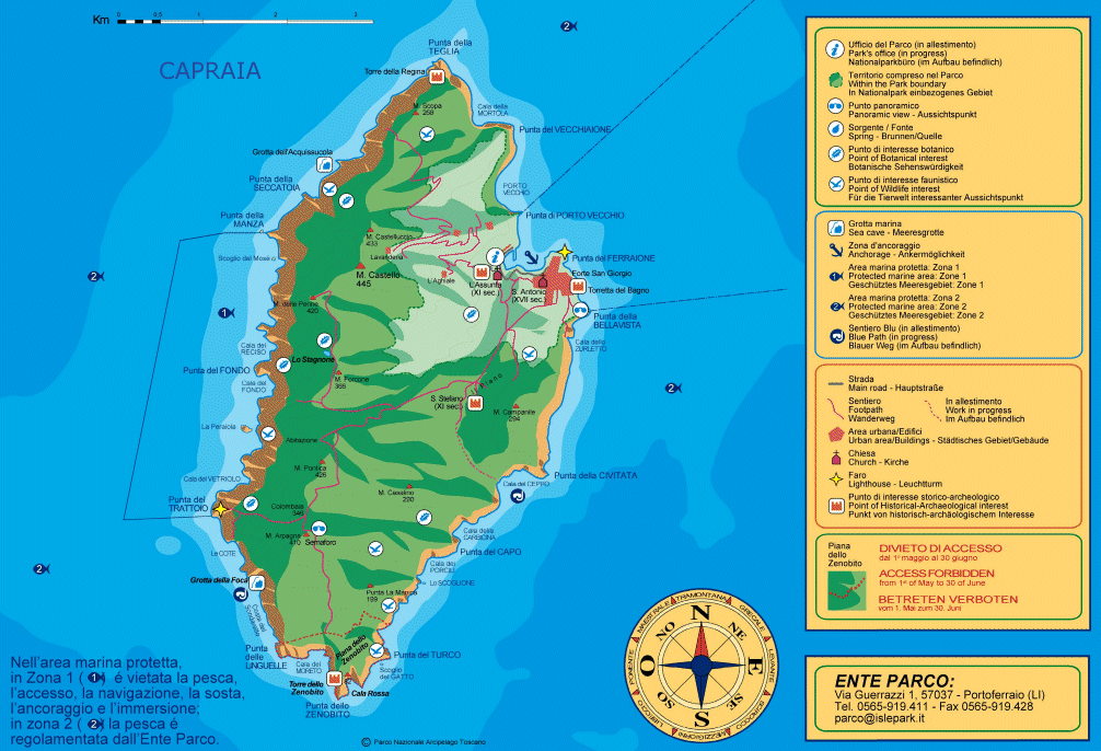
Capraia |
|||
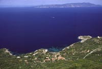
| The volcanic island of Capraia is perhaps the wildest of the inhabited islands in the Tuscan Archipelago. Its distance from the coast and its relative vicinity to Corsica have favoured the development of a typical and exclusive flora and fauna which make the island a perfect laboratory for the observation of nature. A variety of landscapes unroll in the space of a few hundred metres, creating a unique and stunning contrast between the arid asphodel-covered steppe with its windswept saddles and the spectacular water buttercups in the Stagnone marsh (the only natural area of water in the Tuscan Archipelago). Capraia Island is located halfway between the Tuscan coast and Corsica. The island is one of the seven sisters of the Tuscan Archipelago, the third in sizes after Elba and Giglio. It is about 8Kms from Punta della Teglia to Punta dello Zenobio long and is 4 Kms wide. It has got a surface of about 20 square km and with a 30 kms coast. Very frequently from the ferry it’s possible to sight dolphins and cetaceans, especially in the expanse of sea between Gorgona and Capraia. The old village, situated at the foot of the Forte San Giorgio (Saint George Fortress), has maintained its original traits. It is rich in art and history thanks to the many civilizations present on the island at one time or another over the centuries. Very interesting are the typical “tower-shaped houses”: three-story buildings face the village roads or look out directly onto the sea. It’s possible to bring a personal vehicle, camper or boat trailer, but keep in mind that, during the summer, the traffic is regulated: the road may be used only one hour before and one hour after the arrival of the ferry. To facilitate travel between the village and the port, there is a small public bus available. The volcanic Island of Capraia originated approximately nine million years ago, after a series of eruptions, which are still visible at Cala Rossa, the splendid site of the Tower of Zenobito. There is a small harbor on the East side. In the summer months the harbor is hopeless full. Anchoring in the bay adjacent to the harbor is OK. Depth 10-15 meters. Sand and grass. Sometimes in the night, strong falling winds from the South. On the East side there are also a couple of small and not well protected bays for anchoring. The major part of the West side (is not interesting) is under natural protection. The off limits zone is of 1 nautical mile width. |
 |
||
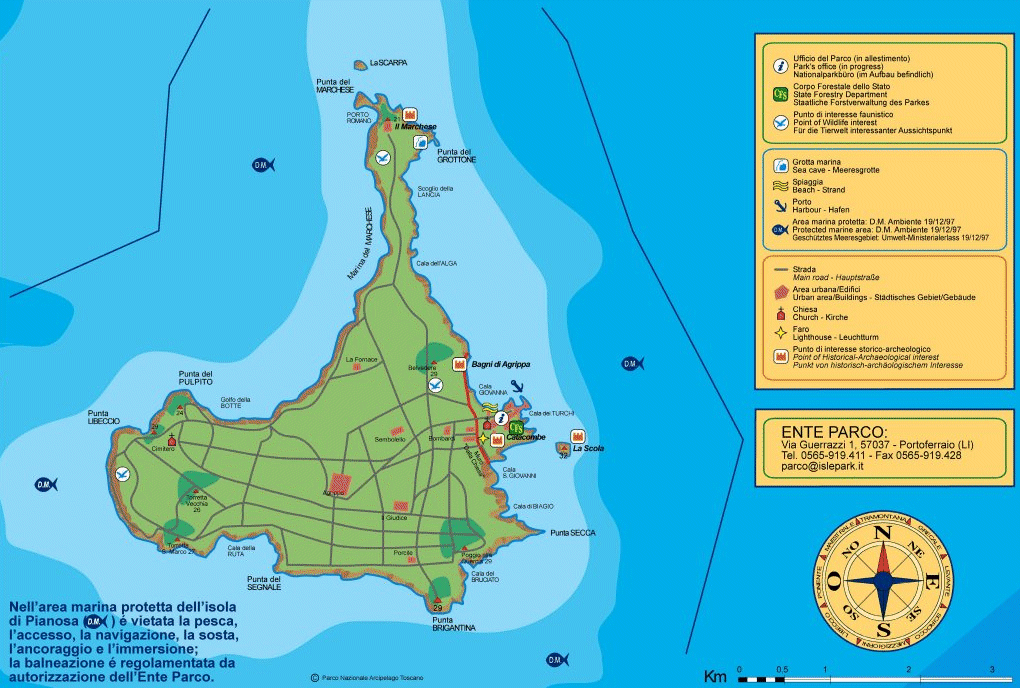
Pianosa |
|||
| Its name comes from the Italian pianura (plain). Pianosa is part of the Elba island municipality. Currently lacking in civil settlements, but still a prison site, Pianosa boasts a rich historical and archaeological heritage as well as being a protected nature reserve. The island possesses a paradoxal contrast between its unusual flat morphology and its high limestone cliffs. It has an original village designed in the very early days of the Kingdom of Italy, the magnificent Paleochristian Catacombs shrouded in mystery, the remains of the thermal baths belonging to Marcus Postumus Agrippa’s luxurious domus, the prison sectors of the oldest Agricultural Penal Colony in the Archipelago, and innumerable coastal paths immersed in the Mediterranean vegetation. Pianosa, after many years spent in solitude and due to the closing of the famous jail, opened its doors to a certain number of visitors. Yet the accessible areas are still fairly limited to the outskirts of the docking zone and the village; besides excursions can be went on only with a professional guide. For about 20 years Pianosa was a high security penitentiary and fully closed to visitors. The waters around Pianosa were off limits between one nautical mile. In 2000 the penitentiary moved away but the island can only be visited with guided tours starting from Elba. The off limits zone of 1 nautical mile still persists. Now-a-day the population is reduced to Penitentiary guards and to less than twenty prisoners, charged to look after the buildings. A roman villa is partially preserved. It is known either as Villa di Agrippa or Bagni di Agrippa, by the nephew of Augustus emperor, who was exiled on the island and there murdered. The architectural features suggest that the villa was built by the I century BC, and early abandoned by the I century AD. In the village visitors are welcomed by the particular architectonic style of the Pianosa harbour, would by Ponticelli, one of the first prison governors. Equally fascinating is the Teglia Fortress, an historic construction dating back to Napoleonic age, from which visitors can go on to the ancient village where a fortified citadel standed. Going through the remarked path visitors can also enter Cala Giovanna, the beach right next to the built-up area, the only authorised bathing place. The walk along the beach lets visitors reach the backside of the ruins of Marco Agrippa's baths; he was confined and then killed in Pianosa to allow Tiberio's accession. At present it is possible to visit the theatre and the court. They were built over the rocky coast in front of the sea, for the leisure of wealthy owners and their visitors. |
 |
||
 |
|||
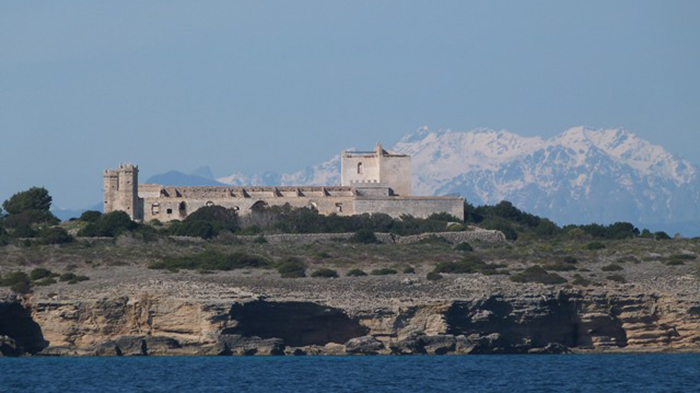
Pianosa, Punta del Marchesein the bachground Corsica. The high mountain areas are snowed in from November to May (photo F. Mezzatesta g.c.). The small island of Pianosa forms part of Italy's Tuscan Archipelago.
|
|||
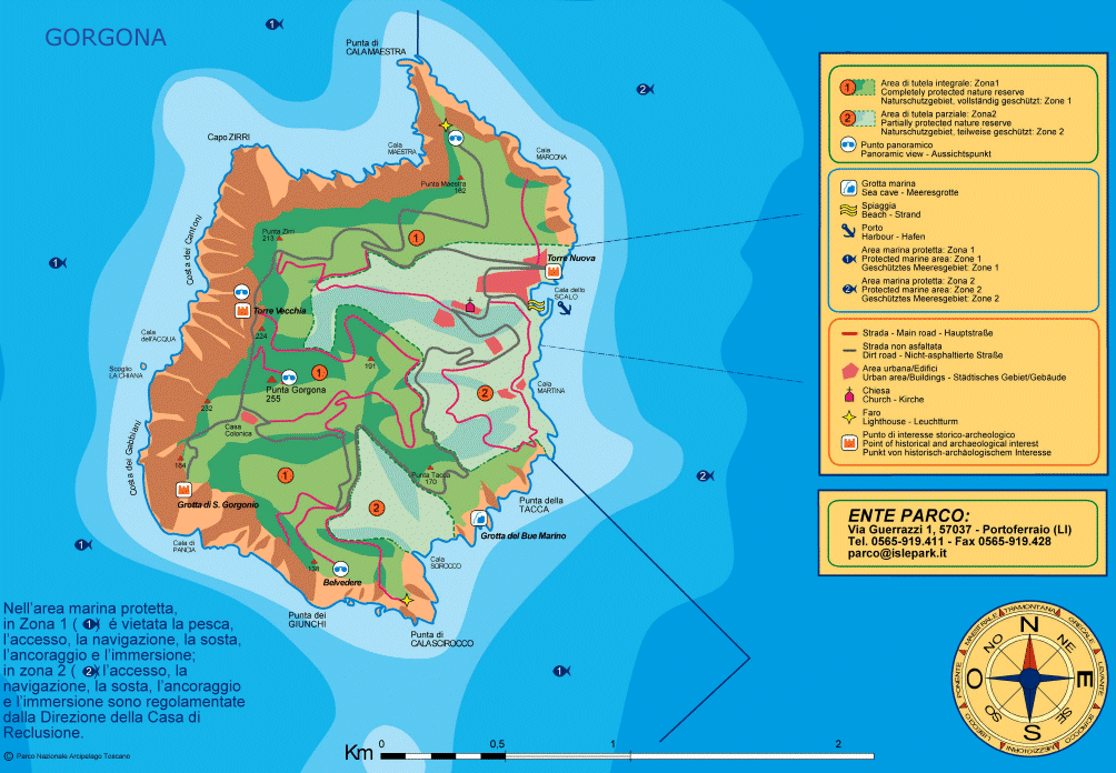
Gorgona |
|||
| The Island of Gorgona is the smallest island of the Tuscan Archipelago. Between Corsica and Livorno, this diminutive island has been valued most for its wildlife, especially marine birds, and its isolation. The latter quality resulted in the foundation of Gorgona Abbey in the Middle Ages. After its closure the monastery grounds and buildings were appropriated in later times as part of an agricultural penal colony, which is currently in use. Along the coastline, there are fascinating coves and bays like the Costa dei Gabbiani or Cala Scirocco where there is the entrance to Grotta del Bue Marino, once the refuge of monk seals. |
 |
||
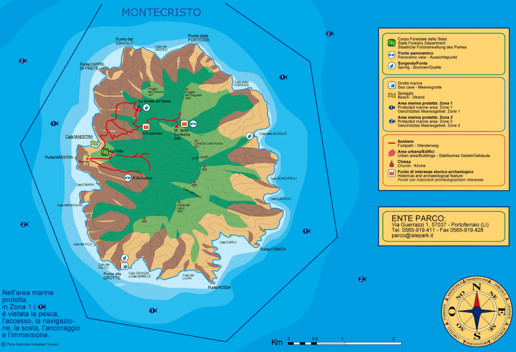
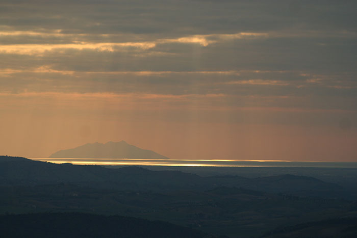
| Montecristo |
|||
| That's the island of the Montecristo count in the novel of Alexandre Dumas. In the Middle Ages a hiding place for pirates. At the end of the 19th century, the French writer set the adventure of the prisoners who were looking for the fabulous treasure which the monks had preserved and protected in the recesses of a cave. A lot of people searched for the treasure described in the novel but never found it. Montecristo is since many years under natural protection and the waters around Montecristo are off limits for 3 nautical miles. Montecristo with a 10,4 square kilometres area and 16-kilometre perimeter, is a naturalistic jewel where only the keeper's family resides and, in summer-time, some forest warders. Montecristo is the most unaccessible of the isles of the . Montecristo indeed opens its doors to the visitor only by grant of the Ministry for Land Reforms Hunting reserve - property of the Savoia family - natural reserve since 1971 and biogenetic reserve of the European Council. Tourists are not allowed to visit the island. The Forest Corp of Follonica organises visits in small groups and you can book it for one day with several month in advance. Montecristo is mountainous, wild and inhospitable. It is hard to get here and the island is almost expugnable due to the huge granite blocks. |
 |
||
 |
|||
Tox, Castagniccia (Corsica) - The island of Montecristo view from the chapel Notre-Dame des Grâces [1]
|
|||
| Formiche di Grosseto |
|||
| The Islands known as the Formiche di Grosseto are also part of the National park of the Tuscan Archipelago. | |||
Agenzia per il Turismo dell'Arcipelago Toscano - Via Carducci, 150 57037 Portoferraio
|
|||
 |
|||
| Monte Christo, view from Podere Santa Pia | |||
Tuscany Walking Festival | www.tuscanywalkingfestival.it Disponibile il programma 2010 del Parco dell'Arcipelago Toscano |
||||||||||||||||||||||||||
| The natural environment and history of the third largest Italian island have often entwined to create an extraordinary mixture of nature and culture, all on such a small piece of land. Walking, riding a horseback or a mountain bike are the best ways to advance the island's stony grounds and woody paths, whence perceive the tiny village below and a lively green nature. Spring and autumn are the best seasons for trekking, with paths that pass the places of the old mines and allows you to discover the most suggestive landscapes of the islands. |
||||||||||||||||||||||||||
| Starting from sea level, you can reach the mountains with a walk of just a few kilometers. You can visit the remains of an Etruscan fortress on high grounds and then dive into the sea from a small beach just one-hundred meters away; and the rock with trees near the shore, more than 2000 years ago was the wharf for the Roman burdened ships.
No other island in the Mediterranean Sea has a granite mountain more than 1000 meters high, and one of the most interesting mineral areas of the world within just a 2-hour walk. Maps of all the tracks of the Island are available at any newspaper kiosk. http://www.aptelba.it/APTView/view?guid=11d1def534ea1be0:671b032:1112bf7cf59:-7ff8 |
||||||||||||||||||||||||||
| The woods on the North-Western coast |MARCIANA (355 m) - SAN CERBONE (531 m) - VALLE DI PEDALTA LA STRETTA (805 m) - MARCIANA (355 m) | ||||||||||||||||||||||||||
This walk starts from Marciana, an ancient medieval village easily reached by bus (ATL). Starting point is the Parish Church of Santa Caterina. http://www.aptelba.it/APTView/view?guid=11d1def534ea1be0:671b032:1112bf7cf59:-7ff7
|
||||||||||||||||||||||||||
| Isola d'Elba |
||||||||||||||||||||||||||
The shepherds path | Time required: 7 hours
http://www.hotelalma.com/hotel-elba-island/elba-trekking-fetovaia.html |
||||||||||||||||||||||||||
How to get there The nearest port is Piombino, where there are two different ferry companies: Toremar | www.toremar.it Moby Lines | www.moby.it The frequency of the connections varies according to the seasons. The crossing from Piombino to Portoferraio on the Island of Elba takes around 50 minutes.
|
||||||||||||||||||||||||||
|
||||||||||||||||||||||||||
|
||||||||||||||||||||||||||