| |
|
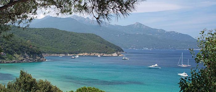
The Island of Elba is the third largest Italian island after Sicily and Sardinia and is the largest in the Tuscan Archipelago. It has recently become part of the Tuscan Archipelago's National Park together with the islands of Pianosa, Capraia, Montecristo, Giglio and Giannutri.
Elba has a coastline of 147 km: its main mountain (Monte Capanne) is 1019 metres high, accessed via pathways or by a panoramic cable car.
Elba is especially remembered for having been the home of Napoleon Bonaparte during his 1814 exile. The houses where he lived, one in Portoferraio and the other in San Martino, are some of the most famous tourist attractions of the entire island.
Already in acient times Elba's destiny was always deternined by two factors: its strategic position and the richness of its mineral resources. Due to these characteristics, it was often the object of conquest for the various powers along the Mediterranean. For the Etruscans and the Romans Elba represented an inexhaustible source of riches and the iron from Elba contributed to the prospering of their civilazation.
During the Medieval period Elba was dominated by Pisa. The remains of some important and striking defensive structures testify to the importance of possessing the island. The AppIani Lordship followed, as did the attentions of Cosimo de Medici, who built "Cosmopoli" on top of the ruins of the Roman city of Fabricia - now the capital Portoferraio - and had it surrounded with the impressive walls that saved the inhabitans from many pirate raids. The Spaniads settled in Porto Azzurro and they too made sure to construct defenses on their territory - the imposing San Giacomo Fort still dominates the pleasant landscape.
In the more recent history, the period that made this island famous and placed it on the world map was the brief exile of Napoleon, who stayed here for 10 month prior to his 100 days adventure which was finished in Waterloo. Bonaparte left a significant mark of his short reign: Important reforms and buildings like his Townhouse Villa dei Mulini in Portoferraio and his impressing summerresidence San Martino - which are now museums and can be visited.
Eight picturesque little towns (Portoferraio, Marciana, Marciana Marina, Campo nell'Elba, Capoliveri, Porto Azzurro, Rio nel'Elba and Rio Marina) are scattered about a rugged land, hilly and mountainous for the most part, crowned by a three thousand foot peak called Monte Capanne.
Portoferraio is situated on a spur of rock and surrounded by the Medicean Fortress that overlooks the town. With its “natural” and principal port, it is singled out as the capitol of the island and seat of most offices and public services.
Marciana Marina is one of the most important towns of Elba Island. There is a small marina (Circolo della Vela Marciana Marina), two small beaches and an old Torre Medicea, built to protect the city in the past from the frequent pirate invasion.
The promenade going from the old part of the city (called Il Cotone) to the Torre Medicea has preserved the original architectonical and urbanistic features of the 18th century. In acient times Elba Island destiny was always determined by its strategic position and the richness of its mining resources.
According to these characteristics, Elba Island has alternate various powers domainations along the Mediterranean.
Etruscans and Romans considered Elba as an inexhaustible source of richenes and the iron from Elba contributed to the prospering of their civilazation.
During the Medieval period Elba was dominated by Pisa.
The remains of some important and striking defensive structures testify the importance of possessing the island.
The Appiani Lordship followed, as did the attentions of Cosimo de Medici, who built "Cosmopoli" on top of the ruins of the Roman city of Fabricia, nowadays called Portoferraio, and had it surrounded with the impressive walls that saved the inhabitans from many pirate raids.
The Spaniards settled in Porto Azzurro and they too made sure to construct defenses on their territory, such as the imposing San Giacomo Fortress that still dominates the pleasant landscape.
In the more recent history, the period that made this island famous and placed it on the world map was the brief exile of Napoleon who stayed here for about 10 months prior to his 100 days adventure which finished in Waterloo.
Napoleon left a significant mark of his short reign and made important reforms and buildings like his Townhouse "Villa dei Mulini" in Portoferraio and his impressing summer residence "San Martino" which are both today a museum.
Recently the island become part of the Tuscan Archipelago's National Park as well as the islands of Pianosa, Capraia, Montecristo, Giglio and Giannutri. From April to October, there are excursions in the Tuscan Archipelago National Park with environmental guides and specialised instructors, involving bird watching, the observation of birds in free flight, and all the other life forms and their natural habitats, in a full immersion into Mediterranean flora and fauna.
|
How to get to Island of Elba
The island of Elba is served by regular sea and air connections and can be reached easily at any time of the year. There is an excellent bus service available on the island, connecting all the main towns and villages. Elba is the largest island in the Tuscan archipelago and the third largest in Italy.
Elba is best visited during the warmer months from May till September. May and September are cooler months but you will be almost alone with the surrounding nature:
Elba is an agreeable one-hour ferry journey from Piombino. If you arrive in Piombino by train, take a connecting train on to the port. Boats to Portoferraio are the most frequent, while some call in at Rio Marina, Marina di Campo and Porto Azzurro.
Boats are run by Moby (www.moby.it) and Toremar (www.toremar.it). Unless it is a summer weekend or the middle of August, when queues can form, simply buy a ticket at the port. Fares vary according to the season.
Toremar also operates a passenger-only hydrofoil service (40 minutes) all year round, and, between June and August, a fast vehicle and passenger service (two people/car trom €69.20 return) to Portoferraio.
With elba.org you can book and purchase tickets for ferries to the Isle of Elba.
Weather & Web Cams On Elba Island
|
Portoferraio, Villa dei Mulini
|
|
|
|
| |
|
Portoferraio
|
|
|
| |
Known to the Romans as Fabricia and later Ferraia (since it was a port for iron exports), this small harbour was acquired by Cosimo I de'Medici in the mid-16th century, when the fortifications took shape.
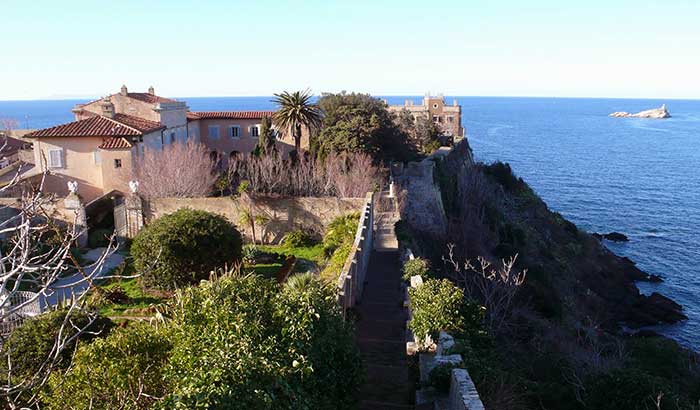
Portoferraio is situated on a spur of rock and surrounded by the Medicean Fortress that overlooks the town. The town center is crowded around the small marina drawn in a natural cove. With its “natural” and principal port, Portoferraio is singled out as the capitol of the island and seat of most offices and public services.
Main points of interest include, Forte Stella, Forte Falcone, Forte Inglese, Archeological museum and Napoleon's house.
Portoferraio was founded by Cosimo I de' Medici, Grand Duke of Tuscany, in 1548, with the name of Cosmopoli ("Cosimo's City"), to balance the presence of the Spanish citadel in Porto Azzurro. It had three forts (Forte Stella, Forte Falcone and Forte Inglese)[1] and a massive line of walls, all still visible today. The city remained to the Grand Duchy of Tuscany until the 18th century, when, due to its strategic position, it was contended by France, England and Austria. In 1814 it was handed over to Napoleon Bonaparte, as the seat of his first exile.
|
|
|
| |
Following the Treaty of Fontainebleau, French emperor Napoleon I was exiled to Elba after his forced abdication in 1814 and arrived at Portoferraio on May 3, 1814 to begin his exile there. He was allowed to keep a personal guard of six hundred men. Although he was nominally sovereign of Elba, the island was watched (more or less) by British naval patrols.
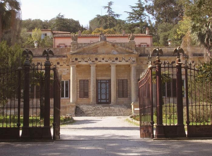
During his “299” day stay, he had to content himself with a 8000 hectare training camp where he built his residence, Villa Dei Mulini, today a national monument situated at the summit of Portoferraio in a panoramic position between the forts Stella e Falcone. From here, one can take in a breathtaking view that includes the northwest coast and the coast of Tuscany. |
|
|
| |
Villa S. Martino (with Museum Demidoff) was Napoleon’s country residence located at the foot of the mountain by the same name, and less than 6 km from the center of town. From the inside one can view Napoleon’s bedroom decorated with the golden bees and stars from the legion of honor, the Egyptian room adorned with frescoes by Pittor Ravelli that illustrates the enterprising undertakings of the young emperor.
|
|
|
| |
In the 19th century, the city grew quickly, due to the construction of infrastructures and the exploitation of new iron mills in Rio Marina. Portoferraio became then main shipping port of the ore towards the mainland, whence the current name, meaning "Iron Port" in Italian.
|
|
|
| |
The Linguella Archaeological Museum, in the Torre del Martello. |
|
|
| |
|
|
|
| |
Market Day: Friday
|
|
|
| |
Principal beaches are La Biodola, Scaglieri, Il Forno, Sansone, Enfola Il Viticcio, L’acquaviva,Seccione, Capo Bianco, LA Paduella, Cala dei Viticcio, La Ghaiae, Le Viste, Il Gigolo, San. Giovanni, Schiopparello, Magazzini and Ottone.
|
|
|
|
Villa S. Martino
|
Marciana
|
|
|
| |
Marciana is situated on the slopes of Mount Capanne on the west side of the Island of Elba at 375 meters above sea level. It is one of the most ancient settlements on the island, its foundations dating back to the year 35 BC.Places of historical and cultural interest are: the Pisan Fortress, the Church of San Lorenzo, the Church of San Cerbone and the Sanctuary of Madonna del Monte.
|
|
|
|
|
| |
|
 |
|
| |
Monte Capanne (1019mt): six trails marked with sign posts and maps that join Marciana, Poggio, SantAndrea, Pomonte, Chiessi and, at the top of the mountain, Valle Nevera which can also be reached from Pozzatello in only 14 minutes by cable car, and from where you can enjoy a fantastic view which includes the entire Tuscan Archipelago, the Tuscan coast and Corsica.
Sanctuary of the Madonna of the Mount: the place where Napoleon met with his Polish friend Maria Walewska. It can be reached from the Pisan Fortress in less than a half an hour.
Hermitage of San Cerbone is a delightful destination only 3 km from Marciana and reached from POGGIO. Cars are absolutely prohibited here where, immersed in a chestnut wood, the medieval structures and lanes are still well preserved. From Poggio on the outskirts of the cemetery, take the narrow country lane that leads to the prestigious hermitage in about 40 minutes.
This itinerary can also be done on mountain bike, departing from and returning to Marciana. Time: 4.30 hours. Max change in level 300 m climbing.
The itinerary starts from the medieval hamlet of Marciana, accessible from Capo Sant’Andrea by ATL bus. The reference point is the parish church of Santa Caterina, which leads into the small historic centre through the medieval gate of Lorena. Climbing stairways and narrow alleys characterise the start of the walk, reaching the large chestnut forest, through which the Hermitage of San Cerbone is reached in about 40 minutes walk to the south-west. It is said that San Cerbone sought refuge here in the sixth century from the hordes of Gunmarith, Duke of the Lombards. However, the small church was not built until much later (15th century).
From the hermitage, a 20-25 minute climb leads to point “A”, and this bendy pathway is followed in a north-westerly direction. The path is almost flat, leading through the rocky ridges of Monte Capanne, and form time to time offering beautiful views. With a bit of luck, glimpses will be had of mountain goats or red-legged partridges scurrying among the granite rocks, or even the majestic flight of the buzzard hunting for small mammals. In spring, the perfumed flowers of the Mediterranean forest can be admired, while beautiful stretches of orchids and violets in the fields and on the rocks provide an unusual colour to the countryside.
Valle di Pedalata is reached after about one hours walk, and from here, crossing a forest of pine and chestnut trees, point “B” is reached. A short climb leads up to “La Stretta”, a small ridge from which on clear days Corsica and Capraia can be seen to the west and central-eastern Elba to the east.
On the return leg, before ending the excursion, it is worth stopping to visit the imposing Fortress (built by the Pisans in the 12th century), and a short distance away, still in the upper part of the historic centre of Marciana, the Antiquarium, the first archaeological museum on Elba, where interesting exhibits from the Bronze, Etruscan and Roman ages are to be seen, and a small botanical garden.
|
|
| |
A stroll between the sea and mountains – Itinerary 1
A brief excursion from Capo Sant’Andrea (10 m a.s.l.) to the Sanctuary of the Madonna of the Mountain (630 m a.s.l.) and back. Time: 5 hours
This excursion is a walk for the reasonably fit, or for those who, without too much exertion, want to walk among the green forests for a few hours and then have a swim at the end in the translucent sea off the north-western coast of the island.
Leaving Capo Sant’Andrea, at sea level, in the early morning, the walk climbs up to an old stone mule track (still in perfect condition) at La Zanca, and then path 13 is taken, which leads through one of the most beautiful forests on Elba in about 30 minutes. Continuing through secular chestnuts and other tall trees, the Sanctuary of the Madonna of the Mountain (630 m) is reached in about 2 hours. Here, there is fresh water in the fountains in the cloister and pleasant shade provided by the secular chestnut trees, black locust trees and pines surrounding the area.
Optional itinerary A). The area surrounding the sanctuary is rich in archaeological findings dating back to the Bronze Age, when the area was inhabited by people from Liguria and the Apennines, who were mainly farmers. To visit these caves, dolmens and “goat pens”, the path towards the north should be taken for a few hundred metres beyond the Sanctuary, reaching the rocky complex known as “L’Aquila”.
Optional itinerary B). For those who like climbing up high, the dominant peak of Monte Giove (800 m) can be reached in about 25 minutes, and is one of the most beautiful places on the western part of the island. Descending beyond the crest towards the west leads to Serraventosa, where there are rocks in the strangest and most beautiful forms imaginable, with a view out over Capo Sant’Andrea, Marciana Alta, Corsica and Capraia. A flat road leads back to the sanctuary of the Madonna of the Mountain from Serraventosa.
After a rest and refreshment, the descent starts in the early afternoon, first down path 3 and then down path 13 through a large grove of chestnut trees. Once the provincial road has been reached in San Rocco, this is followed for about 1.5 km until the turning for Maciarello. From Maciarello, the descent goes through Cotoncello – Sant’Andrea (the path to Cotoncello starts on the left next to an Enel electricity cabin), where a refreshing swim awaits
|
|
| |
Bird Trek: wildlife – Itinerary 5
An attractive itinerary in the mountains to admire the rich fauna on Elba. Time: 5.30 hours.
Departing from the square in Pomonte (30 m) and, facing the mountain, walking up to the left on path 4, which crosses the left hand side of the valley. The path, which climbs up the mountainside between terraces, some of them still cultivated, is the old mule track leading from Pomonte to Marciana. After about an hour, the locality called “La Terra” (550 m), a high plain with wide flat areas, is reached.
This area was inhabited until early in the last century, and there are still remains of the ancient settlements and of two churches: that of San Bartolomeo, on the rocky divide between the Pomonte and Chiessi valleys, and that of San Sebastiano, about two kilometres further north, above the path which continues on to the Sanctuary of the Madonna of the Mountain.
Turning off path 4 onto path 10 to reach the ridge on the Monte Capanne range in the Tabella – Monte di Cote area (900 m), the descent goes down through “La Stretta”, where path 54 is crossed, which leads to the road joining Marciana (370 m) and the Sanctuary of the Madonna of the Mountain, from where there is a quick descent to the village, where the walk ends.
Predators and birds of various species can be seen in flight along the whole itinerary, according to the season. Elba is an excellent place for the migratory birds in the northern Tyrrhenian to stop and seek refuge. The native wildlife includes the red-legged partridge, buzzards, the common kestrel and the northern goshawk, the dormouse, hare, wild boar, martens and mountain goats, which are the most spectacular animals to encounter, but must be approached quietly and from downwind. Mountain goats are a common sight in the area around the Pomonte valley, while “La Stretta” is the best place for bird watching, as it is an obligatory passage from the western valleys to the wide valley of Marciana.
|
|
Hiking maps Elba
Elba and the Tuscan Archipelago National Park |www.stanfords.co.uk
|
|
| |
Elba and the islands of the Tuscan Archipelago on a contoured, GPS compatible hiking map at 1:50,000 from Selca, presenting on one side Elba and on the reverse separate panels with individual islands plus the adjoining mainland.
On one side is an excellent map of Elba with cartography from the Italian topographic survey. Contour lines are at 25m intervals, enhanced by relief shading. An overprint highlights waymarked hiking paths, including GTR – Grande Traversata Elbana and special routes visually impaired and for spotting butterflies or orchids. The map also shows locations of ecotourism accommodation and various places of interest. The map has a 1-km UTM grid.
Also provided is a detailed vegetation map of Elba at 1:100,000. Map legends for both maps are in Italian only.
On the reverse separate panels present the individual islands of the Tuscan Archipelago: Capraia, Pianosa, Giglio. Montecristo, Gorgona and Giannutri, showing the topography and where appropriate roads and waymarked hiking paths. Half of the reverse side is taken by a more general map showing the islands with the part of the mainland, extending to Florence and Siena. The map shows ferry connections and on the mainland roads and railway lines.
|
|
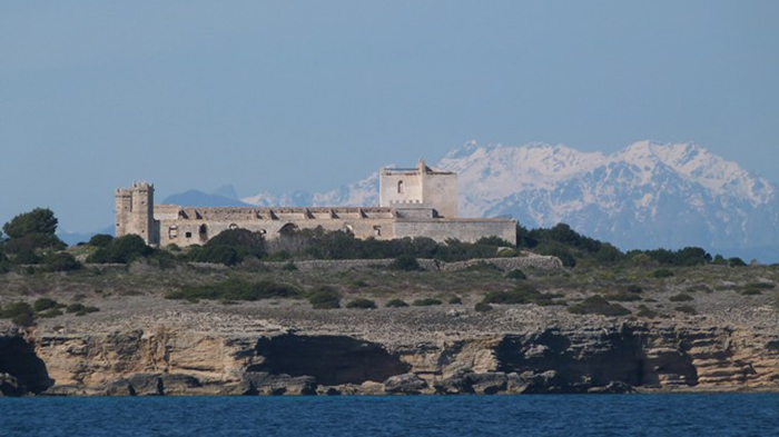 |
| Pianosa, Punta del Marchesein the bachground Corsica. The high mountain areas are snowed in from November to May (photo F. Mezzatesta g.c.). The small island of Pianosa forms part of Italy's Tuscan Archipelago. Its name comes from the Italian pianura (plain). Pianosa is part of the Elba island municipality. |
| |
|
|
| |
|
|
| Busses in Portoferraio |
|
| |
Public Bus Service on the Island is run by the A.T.L that covers the entire Elban territory with bus rides on both urban and extraurban lines. The timetable of bus rides varies with the season increasing from June to September.
www.aptelba.it
Map of the Bus Service on the Island | Schedule |
|
|
The island is connected to the mainland via the two ferry companies, Toremar and Moby Lines, both offering routes between Piombino and Portoferraio, the capital located in the north, Rio Marina and Porto Azzurro, on the east coast of the island. The crossing from Piombino to Portoferraio on the Island of Elba takes around 50 minutes.
Toremar | The Toremar ferry company has been transporting passengers from the mainland port of Piombino to port Portoferraio on Elba, for decades. In addition to a car ferry, Toremar also has a faster hovercraft.
www.toremar.it Moby Lines | The shipping company Moby Lines connects the Tuscan mainland with Elba multiple times daily. The ferries take roughly 60 minutes from Piombino, across the Tyrrhenian Sea.
www.moby.it
Marina di Campo Airport (Aeroporto di Marina di Campo) is an airport located in the area of Marina di Campo which serves the island of Elba in Italy. It is also known as Teseo Tesei Airport ( Aeroporto Teseo Tesei).
|
|
| |
|
|
| |
The island is divided into eight municipalities, of which Portoferraio is the main one, the others; Campo nell'Elba, Capoliveri, Marciana, Marciana Marina, Porto Azzurro, Rio Marina, and Rio nell'Elba, are part of the province of Livorno.
Comuni of the Province of Livorno | Bibbona · Campiglia Marittima · Campo nell'Elba · Capoliveri · Capraia Isola · Castagneto Carducci · Cecina · Collesalvetti · Livorno · Marciana · Marciana Marina · Piombino · Porto Azzurro · Portoferraio · Rio Marina · Rio nell'Elba · Rosignano Marittimo · San Vincenzo · Sassetta · Suvereto |
| |
Restaurants
Ristorante il Cantuccio
| Via Garibaldi, 6 - Marina di Campo
Ristorante Pizzeria Nettuno | Calata Mazzini, 21 - Portoferraio
Ristorante Pizzeria la Cantina del Mare | Via Mascagni, 1 - Marina di Campo
Ristorante Pizzeria il Fosso | Via San Giovanni, 10/12 - Marciana Marina
Ristorante Vesuvio | Via Roma, 376 - Marina di Campo
Ristorante Tahiti | Procchio - Isola d'Elba
Ristorante Pizzeria La Fiaccola | Pz. della Vittoria 6 -
Ristorante Pizzeria Kontiki | Via Molo Nuovo - Marina di Campo
Ristorante Pizzeria il Garibaldino | Calata Mazzini, 1 - Portoferraio
Osteria dei Quattro Rioni | Via Fortezza, 1 - Capoliveri
|
|
|