| |
|
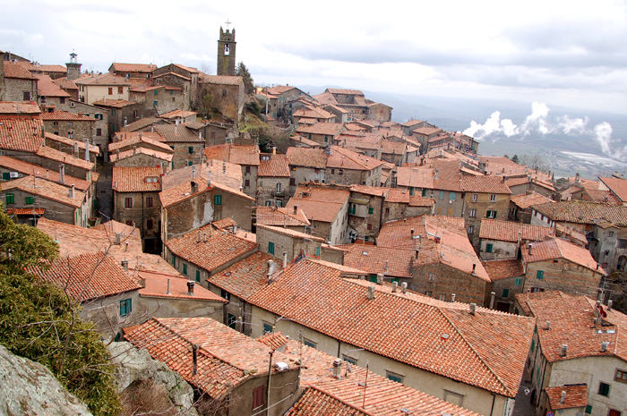
Piancastagnaio has a circular form, once had surrounding wall enclosure with alternating square towers and four gates. The walls and the gates have been almost entirely demolished, with the exception of few lines, but in the highest point of the inhabited area rises still today the mighty Fortress Aldobrandesca. The building has a square shape and high and strongly embanked walls. Two towers rise up from the wall ring, where the largest one, both for its solidity and height, had functions of keep. The other one, placed on the opposite corner, defended the underlying gateway entrance to the city. The whole complex was equipped with a defensive apparatus with projecting corbels and battlements, still almost intact.
An old miners’ path leads to Abbadia San Salvatore.
Weekly market on Saturday.
Comune di Piancastagnaio

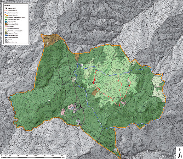
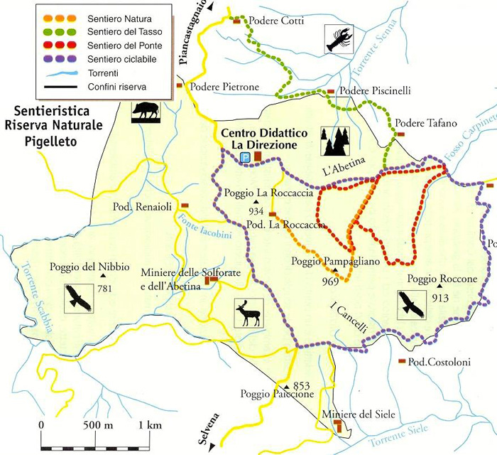
La Riserva del Pigelleto | Pigelleto Natural Reserve Piancastagnaio
The Pigelleto Nature Reserve in Piancastagnaio, between Siena and Grosseto, extends over a territory of 862 hectares. Pigello is the name the people of Amiata give to the white fir, a majestic tree that can reach heights of 50 m.
The Nature Reserve used to host one of the most important quicksilver mines of Monte Amiata, the Siele Mine, today completely abandoned. The Pigelleto Natural Reserve has been incorporated by the Regional Administration of Tuscany (Regione Toscana) in 1996. It used to host one of the most important quicksilver mines of Monte Amiata, today completely abandoned. The Environmental Education Centre La Direzione is inside the Reserve itself and includes the Visitors Centre, the Environmental Education Labs and facilities for visitors who wish to spend some time in peace and tranquillity.
How to get there by car.
- Cassia SS 2 road to Piancastagnaio; then follow the signs for Castell’Azzara, Santa Fiora and Riserva Naturale del Pigelleto (the signs for the reserve are brown).
- From the Tyrhennian coast: follow the route Pitigliano-Sorano-Castell’Azzara or Grosseto-Arcidosso-S. Fiora-Castell’Azzara; then follow the signs for the Riserva Naturale del Pigelleto (the signs for the reserve are brown). |
 |
Carta escursionistica della Riserva Naturale Pigelleto[4]
|
There are many excursion paths that run through the Nature Reserve of Pigelleto. Some paths are part of the marked trail n° 16 (Saragiolo - Miniera del Siele - Castell'Azzara) and n° 17 (Pod. La Roccaccia - Castell'Azzara) created by the Town of Monte Amiata.
The Sentiero Natura (the Nature Trial) begins at Podere La Roccaccia and ends at the Environmental Education Centre 'La Direzione' for a 2.5 km long walk inside the Reserve. Along the way you will find many information sighs about the animals and palnts. At times it coincides with the trial n° 16 that connects Saragolo with the Siele Mines.
The Sentiero del Tasso (the Yew Trial) is part of Route n° 16 and is almost 2 km long. It takes you into the most beautiful and interesting part of the Reserve. This is why visitors must be accompanied by guides and rules are very stricted. During the trip you will see chstneut tress, beeches, silver firs and fern trees. There are also wet lands created by permant water sources.
The Sentiero del Ponte (Bridge Trial) has been traced by the community of Monte Amiata and is 4 km long. It is inside the Reserve creating an 8 whch then coincides with the Nature Trial. Along hte way there is a break area in an old ruin (podere s. Ignazio) surrounded by beeches.
The Sentiero Ciclabile (Cycling Trail) is part of the route n° 16 and n° 17 and is almost 6 km long. The asphalt roads are restricted to mountain bikes only. It runs through the woods of the Reserve and arrives at the cultivated lands that surround the Reserve. It goes up to Poggio Roccone and then down towards the Siele Mines.
|
| |
|
|
|
 |
The Siele Mine | Pigelleto Natural Reserve Piancastagnaio (SI)
Mining on Monte Amiata dates back to ancient times: the Etruscans used cinnabar (the mineral that mercury is extracted from) to paint earthenware and frescoes in tombs, digging up to 40 m into the earth to extract it. The largest deposits are located in Santa Fiora, Castell’Azzara, Abbadia San Salvatore and Piancastagnaio.
The history of the Amiata and its people have known exceptional activity from the second half of the XIX century when the discovery of significant deposits of cinnabar transformed the lives of the people of the Amiata, who, until then, were used to “wooden bread and clouds' wine” and that is polenta (corn meal mush) and water.
The beginning of the mining industry brought economic growth to a very poor land, emancipation and social changes.
From the huge cinnabar deposits mercury was extracted, the quicksilver, essential in precision instruments and in the military industry.
The first mines to be opened were those of Siele, in 1866, whose structures are among the most interesting example of industrial archeology immersed in the Natural Reserve of the Pigelletto.
Then it was the turn of the Solforate in 1873, the Cornacchino's in 1879 and at last the ones of Abbadia San Salvatore at the beginning of the XX century.
In modern times, the Siele mine started to be used for industrial ends towards the middle of the 1800s. Siele was a complex site comprising both mines (galleries and shafts) and plants for working the mineral. In the early 1900s, a village grew up around the site, with houses, schools and a church.
After a period of great expansion, also due to orders from the war industry, mining activity ceased in 1973: it was the third largest mine in the world after Almadén (in Spain) and Abbadia San Salvatore.
Today the plant has been cleared up and partially restored as part of Monte Amiata’s historical and cultural heritage.[1]
Monte Amiata Chestnut Trail
|
The Monte Amiata region is characterized by areas that are very different to one another from the top of the mountain (1600 meters) to the valleys that gradually descend towards the Maremma. The territory of Arcidosso is mostly covered by forests of beech and chestnut trees, the latter in particular play an important role in the economy and the country’s gastronomy.
The chestnuts grown on Mount Amiata (particulary in its western flank wichh includes the municipalities of Castel del Piano, Arcidosso, Santa Fiora e Seggiano) belong to one of the three hundred varieties in Italy.
The chestnut tree (Castanea sativa - from sativus, cultivated) has accompanied mankind since ancient times. Just as much as the vine and the olive tree, the chestnut has fed and sustained the ancient and modern populations of central-southern Europe and Asia Minor, a region from which it probably originated. The chestnut is mentioned in the Bible, Theophrastus, Pliny the Elder, Varrone and Virgil. Its name has (from the Latin Castanea, in turn derived from the Greek Kastanon) been conferred in various forms upon many towns and villages among which Piancastagnaio on Monte Amiata, Castagno di Andrea in the Mugello.
|
|
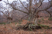
Chestnut tree in Poggio all'Olmo |
The geography of the chestnut is similar throughout temperate European countries. On Monte Amiata and in the Mugello large groves cultivated for the nut cover the slopes of the mountains and centuries-old chestnuts grow in the woods or near to inhabited areas.
Chestnut tree blooms in June. It has spirituous, aromatic scent attracting insects. Since domestic chestnut blooms later than all other fruit, when bees experience lack of pasture, it is almost the only source of nectar at that time and important plant for honey production.
The Castagno dei Cento Cavalli (Hundred Horse Chestnut) is the largest and oldest known chestnut tree in the world. Located on Linguaglossa road in Sant'Alfio, on the eastern slope of Mount Etna in Sicily — only 8 km from the volcano's crater — it is generally believed to be 2,000 to 4,000 years old.[3]
The European Chestnut Trail
|
|
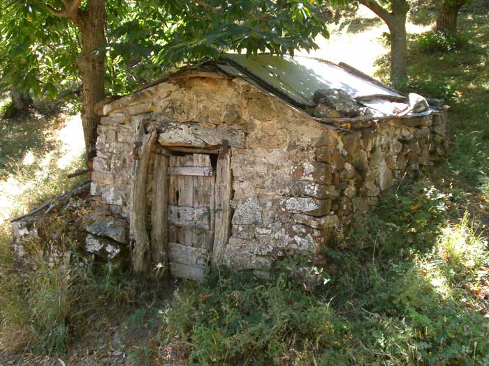
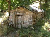 Drying house in chestnut grove, Monte Amiata
 |
The European Chestnut Trail delves deeply into the landscape of the chestnut in the five participating areas, with the aim of recovering farming and cultural traditions, the memory of this landscape and of the populations which live there. The trail is not only an instrument of economic or touristic rediscovery of territories which have been progressively abandoned over time following the development of other crops, but an occasion for a re-evaluation of an arboreal heritage of great significance and value in many of its aspects - botanical, environmental, historical and aesthetic.
The towns of Arcidosso, Castel del Piano, Cinigiano, Santa Fiora and Seggiano which are part of the AMIATA and MAREMMA GALS. In the SIENA GAL the territories of the towns of Piancastagnaio, Abbadia San Salvatore and Castiglione d'Orcia are included. The cultivation of the chestnut has been visibly reduced in the past due to the arrival of other economies, such as the extraction of mercury in particular, which have gradually led to the development of the chestnut farmed for its wood. The poles fashioned from the young copses of chestnut were widely used for the construction of the mineshafts. The surface covered by chestnut groves cultivated for wood is approximately 16.000 hectares, while those grown for the nut is about 800 hectares. New plantings of chestnuts have been recently made in Campiglia d'Orcia. Many giant chestnuts, in a good state of conservation, are grouped in the centre of Piancastagnaio. The chestnut of Monte Amiata on both sides, that of Siena and Grosseto, is recognised by the I.G.P. marque (chestnut varieties, Marrone, Bastarda rossa and Cecio). Among the autumnal festivities dedicated to the chestnut of note are in Piancastagnaio the fair "Il Castratone", in Vivo d'Orcia the "Festa della Castagna", and in Abbadia San Salvatore the "Festa d'Autunno".[2]
Tuscany's Best-Kept Secret | Holiday home Podere Santa Pia
|
|
|
|
| |
|
Piancastagnaio borders Abbadia San Salvatore, Castell'Azzara, Proceno, San Casciano dei Bagni en Santa Fiora.
Comune
|
Trekking in Tuscany
Trekking sul Monte Amiata: percorsi a piedi | Da Abbadia San Salvatore a Piancastagnaio [LUNGHEZZA: 13 Km circa. DURATA: 3 ore 1/2 circa ]
Attraverso la riserva naturale de "il Pigelleto" [LUNGHEZZA: circa 10 Km. DURATA: 3 ore 1/2 circa ]
|
 |
[1] The history of the Amiata and its people have known exceptional activity from the second half of the XIX century when the discovery of significant deposits of cinnabar transformed the lives of the people of the Amiata, who, until then, were used to “wooden bread and clouds' wine” and that is polenta (corn meal mush) and water.
The beginning of the mining industry brought economic growth to a very poor land, emancipation and social changes.
From the huge cinnabar deposits mercury was extracted, the quicksilver, essential in precision instruments and in the military industry.
The first mines to be opened were those of Siele, in 1866, whose structures are among the most interesting example of industrial archeology immersed in the Natural Reserve of the Pigelletto.
Then it was the turn of the Solforate in 1873, the Cornacchino's in 1879 and at last the ones of Abbadia San Salvatore at the beginning of the XX century.
[2] The European Chestnut Trail currently includes five territories within four regions in Italy, Portugal and Spain. Monte Amiata and Mugello in Tuscany, Valle Camonica in Lombardy, Alto Torneqc in the Trâs os Montes and Comarca di Monterrei in Galicia. They all adhere to the Transnational Cooperation project Castanea, created and run by seven GALs (Local Action Groups) in their respective countries.
[Source: The European Chestnut Trail, funded by the Leader 11 European Community Initiative, Ospedaletto, 2001 | www.castanea.it]
[3] 4,000 years old according to the botanist Bruno Peyronel from Turin. [Lewington, Anna; Edward Parker (2002). Ancient Trees: Trees That Live for 1,000 Years. Sterling Publishing Co. p. 92. ISBN 1-85585-974-2.]
[4] Monte Amiata | Carta escursionistica della Riserva Naturale Pigelleto
La Rocca in the 1930's
|

Fonte- La Toscana CTT, Pubblico dominio, https://it.wikipedia.org/w/index.php?curid=4753603
|
| |
|
|

