|
|
| N L | Monteriggioni |
|
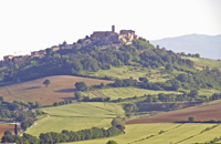
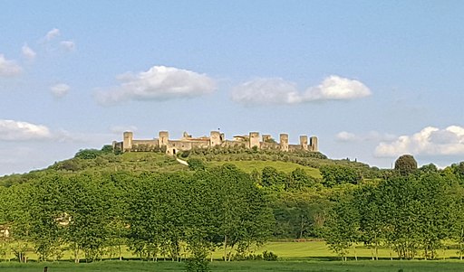
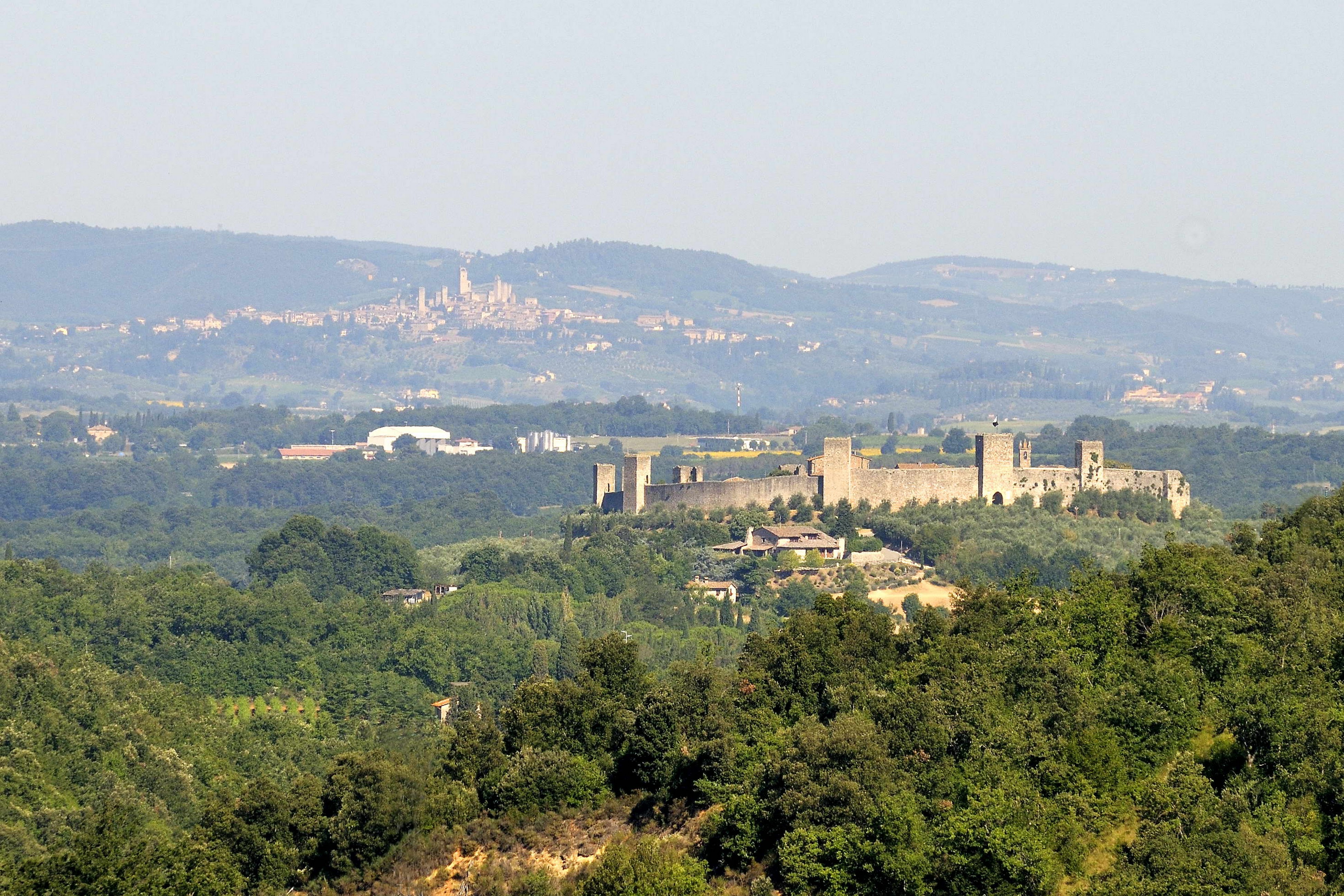
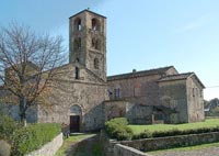
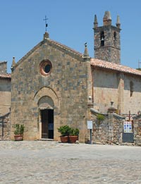
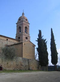
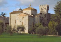
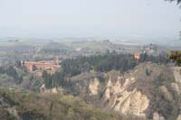
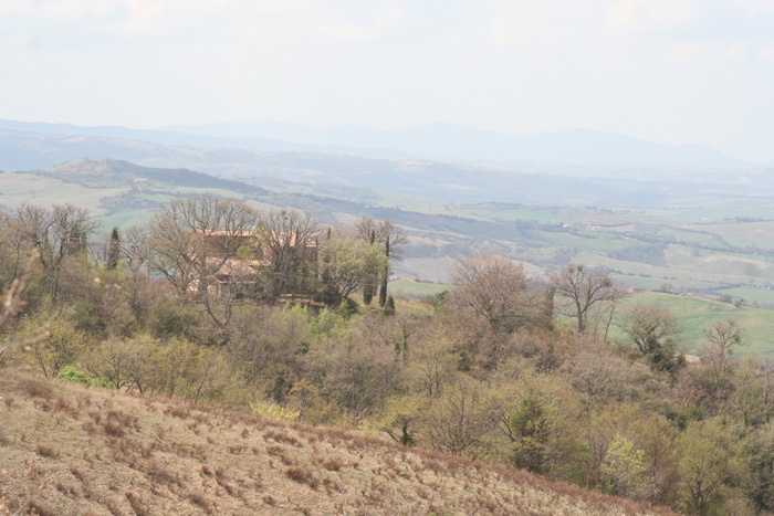
| Monteriggioni is perhaps one of the most evocative medieval villages in Italy, stuated 14 km from Siena. Monteriggioni has became famous for its fourteen towers' walls which are among the best preserved all over Italy. The walls and towers are virtually intact, and the visual effect from a distance is quite astonishing. The main piazza, the Piazza Roma, is dominated by a Romanesque church with a simple, plain facade, the Chiesa di Santa Maria Assunta. Other houses, some in Renaissance style and once owned by local nobles, gentry and wealthy merchants, face into the piazza. Within the walls, just beneath them, there are the vegetable gardens of the villagers, which during the medieval times were used to survive. During the battles between Siena and Florence village people used to cultivate potatoes and onions; they had also chickens and rabbits to eat. After this ring of vegetable gardens there are the villagers' houses and on the middle of the village the church' square with its belfry used to call devotes early in the morning, at midday and at sunset. When there were sieges the belfry singed more often to advice of the coming attacks. They say that the smaller higher towers of the walls, called torrini, were destroyed by the villagers themselves to avoid their debris falling inside when the invaders shot them by cannon or catapult. Afterward they have been rebuilt at the beginning of the twentieth century. But they have been rebuilt just on one side of the walls (that one visible by the roads outside) just for show of the village itself. The main road was at that time the so-called Cassia road, which cross the valley under Monteriggioni on the west side of it: so the towers are on that side.
|
|
|||
 |
||||
Le mura e le torri di Monteriggioni, borgo fortificato [2]
|
||||
Weekly market in Monteriggioni is on Thursday (Piazza della Pace, Castellina Scalo 8:00-13:00).
|
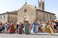 Monteriggioni Crowned by Towers Festival |
|||
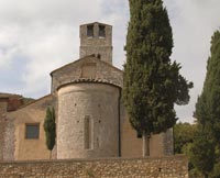
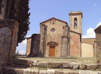
| Abbadia Isola, reached on a one-hour foot excursion from Monteriggioni, is a small town named after its breathtaking 11th-century Benedictine abbey. Abbadia Isola, Island Abbey, so named in ancient times because of its raised position with respect to the marshland that encircled it. Abbadia Isola grew around a Cistercian Abbey called San Salvatore, founded in 1001 by Ava a member of the noble Lombardi family who were lords of the surrounding lands. The site was chosen because of its proximity to the Via Francigena. Unsurprisingly, its sights are mainly religious. The plan of the church in the village of follows the basilican style with three aisles leading to three apses. There is a beautiful central stairway on the inside, a baptismal font dating back the 1400's and a precious polyptych attributed to Sano di Pietro dated 1478. The Romanesque Chiesa dei Santi Salvatore e Cirino guarding a grand 14th-century Maestà by an unknown local artist. There are also some frescos and the famous altar by Taddeo di Bartolo, one of Duccio di Boninsegna’s disciples, showing the Virgin and the Child. The 14th-century Eremo di San Leonardo al Lago retaining a large cycle of frescos by Lippo Vanni and a fresco Crucifixion (regarded as one of the pinnacles of 15th-century Sienese art) by Giovanni di Paolo. The fields surrounding Badia a Isola were once a large swamp or bog that accumulated rain water from Monte Maggio. Isola refers to an island or the only solid piece of land on which the original borgo was built. Now the Abbey is surrounded by flat fields filled with sunflowers in summer, and it is an easy and enjoyable walk from Monteriggioni. On Christmas Eve, a torchlight procession takes place along the Via Francigena. It starts from Piazza del Castello of Monteriggioni and proceeds along the ancient road to Abbadia Isola. Casole d'Elsa is a charming medieval hilltop town and rises along the left side of the valley of the Elsa river. Casole d'Elsa originally was developed in three distinct sites, Il Borgo of Santa Caterina, Il Castello di Piticciano, and Il Piano. La Rocca is the most important civil building in Casole, today the seat of the Town Hall. The medieval walls, mainly visible on the Westside of the town, enclose it. In the middle of the village runs the main street from north to south, dividing it into two nearly symmetrical parts. Among the most important monuments to see in Casole d'Elsa we point out here the Collegiata, the Palazzetto della Canonica, the Chiesa di Santo Spirito (Holy Spirit Church), the Chiesa di San Pietro (Saint Peter Church), the Chiesa di San Niccolò (Saint Nicholas Church) and the Palazzo Pretorio (Praetorian Palace). The Pieve of San Giovanni Battista, at Mensano, is also from the 12th century. Notable are the sculpted capitals of the columns dividing nave and aisles, considered amongst the finest examples of Romanesque sculpture in the Siena area. From the same period and style is the Pieve di San Giovanni Battista, at Pievescola. Weekly market in Casole d'Elsa is on the first and third Monday of the month (Piazza della Liberta 8:00-13:00. |
 Abbadia Isola
|
|||
|
|
||||
 |
 |
 |
||
Monteriggioni |
Monteriggion, panorama |
Monteriggioni, borgo fortificato
|
||
 |
 |
 |
||
Monteriggioni dall'alto |
Monteriggioni, sul sfondo San Gimignano
|
Monteriggioni e Dante Alighieri
|
||
 |
 |
 |
||
Monteriggioni, Piazza Roma met de Chiesa Santa Maria Assunta
|
Monteriggioni, borgo fortificato |
Storia e costruzione del Castello di Monteriggioni, uno dei più famosi borghi fortificati della Toscana |
||
 |
 |
 |
||
Casole d'Elsa
|
San Gimignano, morning | Chiesa di Santa Maria Assunta, Monteriggioni |
||
|
||||
 |
 |

| ||
| Abbadia a Isola, Facciata | Abbadia a Isola, tribuna
|
Interno della chiesa di Abbadia Isola | ||
| Colle Ciupi |
||||
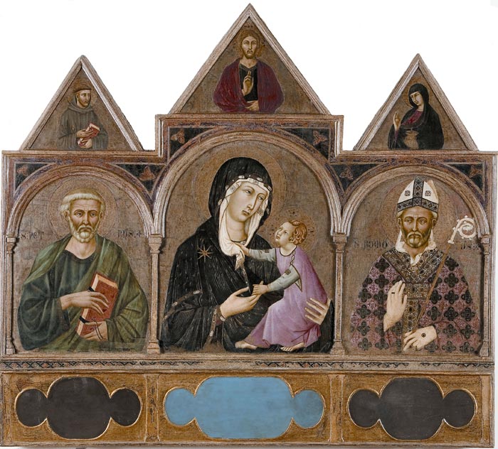
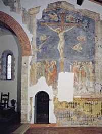
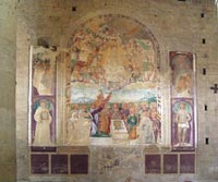
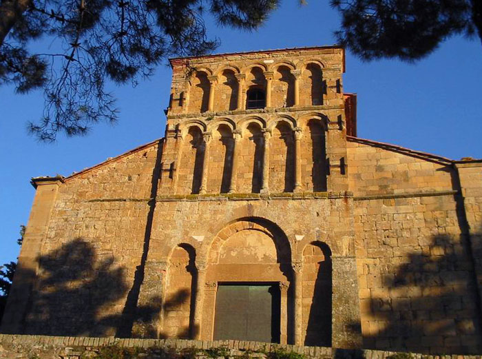
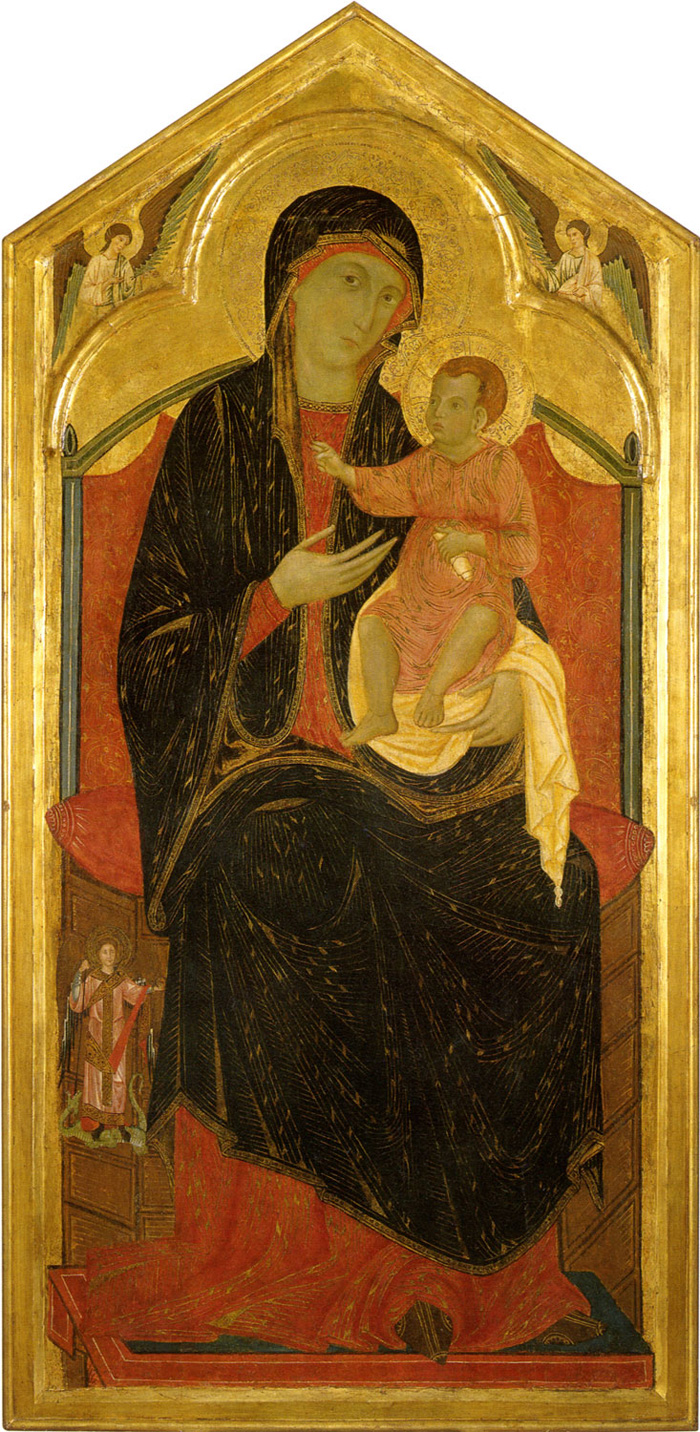
| The small church of San Lorenzo al Colle Ciupi (Monteriggioni) keeps several figurations in the style of Duccio, made by different craftsmen during various periods of time between the end of the 13th century and the thirties of the following century. It is a serie of amazing interest particularly because it allows to compare artists in the style of Duccio coming from three different generations. Santa Colomba In the parish of Santi Giovanni e Paolo in Santa Colomba (near Monteriggioni) two big scenes, with the "Crocifissione" ('Crucifixion') and the "Natività" ('Nativity'), are kept. These are great quality works of a craftsman culturally influenced by Duccio, marked by a strong dramatic and touching inclination that not only relates him to Ugolino di Nerio, but with the young Pietro Lorenzetti as well. The ancient Castel Pietraio was once an important medieval defensive outpost of Siena. At the end of the 10th century, nearby Strove and Staggia were under the rule of the Countess Ava Lambardi, a descendent of a noble Longobard family, whose sarcophagus is still on view in the right aisle of the abbey at Abbadia a Isola. The countess Ava and her husband Ildebrando had two sons, Tegrimo, who married Sindrada, and Berizio, who founded Poggio Berizio, now Poggibonsi. The most ancient part of Castel Pietraio is the 10 C tower with its Guelph battlement. Construction dating from 1300 to 1500 created the quadrangular ground plan with its internal cloister and a well. The construction of the church dedicated to the Saints Peter and Paul is of the same period. Castel Pietraio is now the home of the Fattoria di Castel Pietraio. This winery is part of the district of the Montagnola Senese, located at the foot of Monte Maggio. |
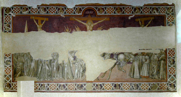
 Artist in the style of Duccio, Crucifixion |
|||
| Sovicille is located in the Val di Merse, an area of lush forest and mediaeval villages 12 km from the centre of Sienna, and has played a remarkable role in the history of Republic of Sienna. One of the main monuments of the Sovicille area is the Pieve di San Giovanni Battista, a romanesque structure with three naves located close to the remains of a gothic cloister. The Pieve di San Giovanni Battista is better known as the Pieve di Ponte allo Spino and was originally built in the second half of the 12 C by Vallambrosan monks and shows many similarities with contemporary French architecture. [read more] |
 Sovicille, Pieve di San Giovanni Battista |
|||
La montagnola senese is the group of hills to the wet of Siena, peaking just south of Monteriggioni. It's ft great area for hikers and riders with plenty of Roman and Etruscan archeological sites, and little villages to explore. The Montagnola Senese extends in the districts of Siena, Monteriggioni, Sovicille and Casole d'Elsa. Ancaiano - this place was already inhabited in the first period of the Bronze Age. The chiesa di San Bartolomeo ad Ancaiano is dedicated to San Bartolomeo and was built in Renaissance-style in 1660, thanks to Pope Alessandro VII Chigi. The church is aisless, it is on the plan of a Latin cross and at the end there is an apse with projecting transept. Capraia - the castle of Capraia stands upon a craggy hill. The Ardengheschi Family had this castle built in order to protect their estate, when Siena had their previous castle of Orgia destroyed. Rumors said that it was impregnable because of its three boundary walls and because it stands upon a rocky hill. In 1100-1250 the Republic of Siena and the Ardengheschi Family contended this castle, then several owners succeded, till the last noble family that arrived here on the 24th September 1554; all the Family members were slain together with all the inhabitants of the village by the Marquis of Marignano's troops. The Marquis had an agreement with the Medici Family, according to which he had besieged Siena, that was nearly surrendering. Nowadays it is possible to see the tower that has been recently restored by the current owners. |
|
|||
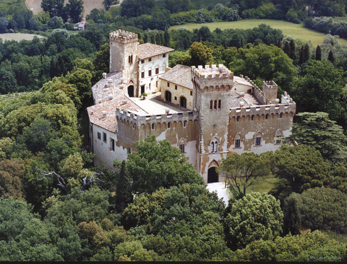
Castello di Celsa - the first informations about the castle date back to the 1st August 1344. The Celsi Family, who owned the castle, had it rebuilt in order to transform it in a villa according to Baldassarre Peruzzi's plans, who also conceived the gardens. Nowadays it is possible to see only the southern tower of the previous building. Malignano - Some documents written before the year 1000 mention the castle of Malignano. There is an oratory dedicated to the Archangel Michael; in this place the Ardengheschis and the Republic of Siena subscribed some agreements. In 1259 the village was burnt and destroyed by the Florentine troops. Molli - the first documents about the parish church date back to 1078; on 2nd February the countess Matilde of Canossa gave the Bishop of Volterra this church as a donation, however, according to some researches into the walls, it could have been built during the Longobard period or the Frankish one. It is a church with nave and two aisles; the altar has been rebuilt, probably by using the stones of the bell-tower destroyed by a lightning in 1930. The front has a symmetrical structure and has been probably rebuilt in the first years of the XVIII century. The recently restored Castle of Montarrenti, is a beautiful medieval hamlet near Siena. Recent archaeological excavations have dated the origin of Montarrenti between the second half of the 7th and the first half of the 8th century as a village of huts encircled by two timber palissades. The fortified settlement was formed by two parts: the castle itself with the keep on the top of the hill and the underlying village occupied by the peasant and little landowner. Today the castle's hill is still dominated by two massive towers built in worked stone with fine carved details like round arched windows, gothic windows, loopholes, gothic and Romanesque style portals. Palazzaccio - ancient fortified building of the Republic of Siena. In 1333 the village was burnt by the troops of Pisa; it is still possible to see the damages, as the building has never been cleaned nor rebuilt. Palazzo al Piano is found at about 430 mt. below the Poggio della Caprazoppa (hill of the lame goat). The castle of medieval origin, presents a rectangular scarpa base and on the east side you can see a well conserved arciera. The rest of the building was reconstructed in the XIX century. It used to be called the Palazzo of Balbiano, then later the Palazzo of Palpiano and finally Palazzo al Piano. it has Medieval origins and stands at a height of about 430 m. / 1416 ft. The old parish church of Santa Maria in Pernina, nowadays known as the Parish Church of San Giovanni Battista in Pernina, is set in a splendid position at 500 m. a.s.l. Personata - this small deconsecrated church, dedicated to Santa Margherita, has ancient origins, probably Etruscan origins, but the first informations date back to the XIII century. Pieve di ponte allo Spino - this church already existed in 1050 and it was a halting-place along the road that linked the "Via Cassia" to the "Via Aurelia". Under the courtyard some precious mosaics of the Roman Empire Age have been found; they were part of a large Roman villa. The entrance of the church is interesting, as you have to go down some steps to enter the church. It consists of a building with nave and two aisles and it was built in late Romanesque French style, that is quite similar to the Gothic style. The capitals are gracefully decorated with human figures and geometrical ornaments. Ponte della Pia - (Pia's Bridge) it is the most charming bridge of this area. In Etruscan times an ancient road crossed it; the bridge linked the Merse Valley to the Maremma Toscana. The bridge has probably Roman origins and it has been rebuilt during the Middle Ages in Romanic style. According to some legends, the beautiful Pia, Nello d'Inghiramo de' Pannocchieschi's sorrowful wife, crossed this bridge to go into exile in Maremma, at Castello della Pietra. Dante Alighieri, too, wrote about this legend (Divine Commedy, "Purgatorio", Canto V). San Giusto a Valli. The first informations about this parish church date back to 994; it originally had a nave and two aisles, but nowadays there are just two aisles, because of an intense intervention made in the XV century. The beautiful church well dates back to the XII-XIII century; it was built by using semicircular limestone blocks. Simignano - it stands at a height of about 410 m. / 1345 ft. along the road that goes from Ancaiano to Pievescola; it has uncertain origins, but it probably dates back to the Roman Age. The first informations date back to 1163, when it was subdued by Siena. The beautiful, small church is dedicated to San Magno and it has a wonderful bell-tower, which is simple but graceful. Torri - small Medieval village, where the Abbey of Santa Mustiola is, which was built in the XII century and has a wonderful cloister. The small villages of Tonni, Toiano, Tegoia and Abbadia Isola are really charming: they have stayed as they were, and here time seems to have stopped. Villa San Chimento built in the late 16th century by the Accarigi family, is an imposing two-storey building.
|
||||
 |
||||
Monteriggioni, Chiesa di San Leonardo al Lago, frescoe by Giovanni di Paolo |
||||

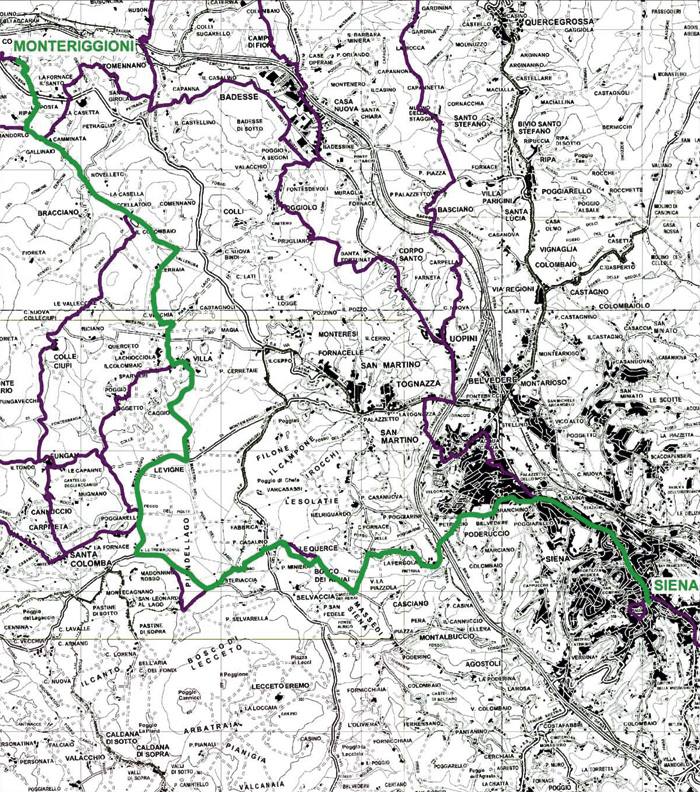
| The south-west part of the municipality of Monteriggioni is occupied by the so-called Montagnola Senese, a hilly area that reaches a maximum height of 671 metres with Mount Maggio. The entire mountain is covered with kilometres of paths which lead up to the gates of Monteriggioni, making it an ideal place for trekking fans. Many paths can also be travelled on horseback and by mountain bikes. The area is of great natural interest, characterised by woods of turkey oak, ilex oak, hornbeam and chestnut and inhabited by boars, porcupines and foxes. Along some of the trails which frequently look over breathtaking views there are many amazing natural grottos and stone quarries, amongst which are those of the precious "yellow Siena” marble. You can reach the majority of the hamlets, castles and monasteries located in Monteriggioni via this network of paths, therefore limiting the need for motor vehicles. The paths of the Montagnola have an official numbering system assigned by the Club Alpino Italiano (CAI) [Italian Alpine Club] of Siena (from 100 to 118) and are indicated along the routes by white and red signposts (reference map: Itinerari nella Montagnola Senese e Bosco di Lecceto, ed. multi-graphic - scale 1:25000; on sale in the Monteriggioni tourist offices). Over the past few years, the valorisation of a number of specific thematic routes has been promoted (such as that of the Via Francigena), which exploit the various routes that are different to those with CAI numbering. A specific map was produced for the occasion (“Hiking the Montagnola”) and special signposting installed. More recently the same has been done to promote specific routes for mountain bikes, for which there is a map (“Pedalare sulla Francigena”) and signposting. [Source: Nature trails | Monteriggioni AD 1213 | www.monteriggioniturismo.it/en/nature-trails.html] Percorsi trekking | Trekking nella Montagnola senese tra Monteriggioni e Badia a Isola | Anello Monteriggioni | Monteriggioni – Badia a Isola – Castel Petraia – Monte Maggio The Via Francigena This is the main road which, for centuries before the year one thousand, connected the north west of France with Rome. Siena region via Francigena web site with maps to download | www.francigena.provincia.siena.it |
|||
| La Via Francigena | Da Monteriggioni a Siena |
|||
| Total length 20.4 km Walk time 05:32 (hh:min) Leave the city centre of Monteriggioni, walk down white streets of the Sienese mountain towards Cerbaia, an ancient Medieval village that is abandoned today. Walk through the brush heading for the castles of Chiocciola and Villa, before going down the riverbed of Pian del Lago. Then go through the wood of Renai before reaching Porta Camollia, a traditional Francigeno access to Siena. The route, quite short and easy, is made hard by the total shortage of water and road-houses. |
 |
||
| Walking in Tuscany | San Leonardo al Lago - Eremo di Lecceto - Ponte allo Spino |
|||
| A straight uphill road leads from San Leonardo al Lago to the Eremo di Lecceto, a fascinating place that has always been consecrated to spirituality in the Agostinian discipline. From the 13th to 19th centuries it was home to Agostinian clerics, subsequently banished by Napoleon. It subsequently housed a closed community of Agostinian nuns. The itinerary continues toward the aqueduct and then reaches the farmhouse Pianali. Wooded paths lead downhill to Toiano and then amidst vineyards to Ponte allo Spino, not far from the locality's lovely church. We are now in the vicinity of Sovicille and Val di Merse, where the Montagnola range unfolds in a wide valley. The church, more specifically the Pieve di San Giovanni Battista, is an unmissable stop. It is undoubtedly one of the richest examples of Romanseque architecture in Terra di Siena. | 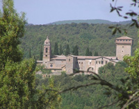 Lecceto |
||
| Eremo di Lecceto - Eremo di Lecceto | 60 km, 9 hours in 2 legs |
|||
| This itinerary leads us through the great diversity of Terre di Siena, from the red soil of the Montagnola to the clay hills of the Crete stretching from Poggio ai Frati to Mociano and onward to the volcanic plateau from Monteliscai to Valiano. The skyline of Siena is always in sight, dominated by the Torre del Mangia and dome of the cathedral, as we discover the primary characteristics of Siena's magnificent landscape. |
 Eremo di Lecceto |
||
| Eremo di Lecceto - Fattoria di Mociano | 25 km, 5 hours |
|||
| Our tour begins near the Eremo di Lecceto (12th century) which still hosts a convent of enclosed Agostinian nuns. It's worth a stop, given that the courtyard and church are open to the public. The first part of the itinerary consists mostly of stone trails travelled since 1100 and leads to Castello del Palazzaccio near the Medieval village of Toiano. While crossing the tiny town, the 18th-century villa overlooking it is readily visible. Once outside the village, we ride on level terrain and cross the Fosso dell'Arnano, a hydraulic device commissioned by the Tuscan Grand Duke Pietro Leopoldo I to facilitate the drainage of the swampy Pian del Lago. By way of Carpineto we arrive in Fogliano, home to a 14th-century Romanesque church. At this point we enter the southern part of the itinerary, which explores the magnificent hill country of the Crete and encounters the castle of Poggio ai Frati (12th century), undoubtedly one of the most enchanting moments of the ride. We then cross the towns of Isola d'Arbia and Taverne d'Arbia, finally reaching the Fattoria di Mociano. |
|||
| Fattoria di Mociano - Eremo di Lecceto | 35 km, 6 hours |
|||
| We are at the easternmost point of our tour, and head north toward the Fattoria di Monaciano, a historical estate dating back to Medieval times. We have passed from the clay of the Crete to the volcanic tufo soil typical of the Chianti, where the landscape is made up of hills, country roads, woodland and vineyards. Having crossed the Chiantigiana road, we encounter Valiano, just by the stable of Luigi Bruschelli, better known as Trecciolino, one of the most successful jockeys in the Palio, the traditional race run twice yearly in Piazza del Campo. By crossing through vineyards we climb toward Vignaglia and reach the area of Pian del Lago, where the gentle hills of the Montagnola Senese begin. From here we proceed toward the 14th-century Eremo di San Leonardo al Lago, protected by a thick cover of Mediterranean brushland featuring oaks and live oaks. Here the final stretch leads back to the Eremo di Lecceto, thus completing the tour. |
|||
| The local unit of CAI maintains a network of trails departing from Santa Colomba (CAI lO2 to Monteriggioni, Cal l06 to Abbadia lsola, and CA1114 through Tegoia to Molino d'Elsa). |
|||
| Itinerary along the Via Francigena |
|||
| Another itinerary along the Via Francigena runs through Val d’Elsa, an area of Tuscany that is particularly rich in castles and ancient churches. Starting at Siena, take the Via Cassia towards Monteriggioni into the Pian del Lago, where there is the imposing Castello della Chiocciola castle. After reuniting with the Cassia, the Via Francigena continues towards Poggibonsi, where there is the Castle of Lecchi. A little further on stands the Castle of Strozzavolpe, with the Pieve di Luco and a beautiful Romanesque church at Talciona. Back towards Poggibonsi, follow indications for Castellina in Chianti, where at Cedda there is a 12th century Romanesque church dedicated to St Peter. Again from Poggibonsi, follow signs to Certaldo, which was a favourite stop for pilgrims and is still today known for its hotels and hospitals. |
|||
| Walking in Tuscany | Maps |
|||
| Crete Senesi: 1 - Val d'Arbia; Asciano, Buonconvento, Monteroni d'Arbia, Rapolano Terme, S.Giovanni d'Asso, Trequanda A cura della Provincia di siena, foglio n°517, scala 1/25000, Edizioni Multigraphic. Crete Senesi: 2 - Crete Senesi; Asciano, Buonconvento, Monteroni d'Arbia, Rapolano Terme, S.Giovanni d'Asso, Trequanda A cura della Provincia di siena, foglio n°518, scala 1/25000, Edizioni Multigraphic. |
|||
Link | Tutte le cartine e guide della provincia di Siena |
|||
|
|||
Monteriggioni borders the communities of Casole d'Elsa, Castellina in Chianti, Castelnuovo Berardenga, Colle di Val d'Elsa, Poggibonsi, Siena and Sovicille. Abbadia a Isola, Badesse, Basciano, Belverde, Castellina Scalo, Ceppo, Colonna di Monteriggioni, Fontebecci, Quercegrossa, Riciano, Santa Colomba, Scorgiano, Stomennano, Strove and Uopini are frazioni of Monteriggioni. Sovicille borders Casole d'Elsa, Chiusdino, Monteriggioni, Monteroni d'Arbia, Monticiano, Murlo and Siena. Rosia, San Rocco a Pilli, Stigliano, Torri, Volte Basse are frazioni of Sovicille. |
||||
Communities van de provincie Siena | Abbadia San Salvatore · Asciano · Buonconvento · Casole d'Elsa · Castellina in Chianti · Castelnuovo Berardenga · Castiglione d'Orcia · Cetona · Chianciano Terme· Chiusdino · Chiusi · Colle di Val d'Elsa · Gaiole in Chianti · Montalcino · Montepulciano · Monteriggioni · Monteroni d'Arbia · Monticiano · Murlo · Piancastagnaio · Pienza · Poggibonsi · Radda in Chianti · Radicofani · Radicondoli · Rapolano Terme · San Casciano dei Bagni
|
||||
|
||||
 |
 |
 |
||
Podere Santa Pia, garden |
Podere Santa Pia |
Abbadia d’Ombrone and Monastero d’Ombrone near Castelnuovo Berardenga. |
||
 |
 |
|
||
Siena, Duomo |
Florence, Duomo
|
Monteriggioni e Dante Alighieri | ||
 |
 |
 |
||
Colle di Val d'Elsa |
Abbazia di Monte Oliveto Maggiore |
Siena, Palazzo Publico |
||
| The Val d'Elsa | ||||
| The Val d’Elsa lies between the provinces of Florence and Siena. Divided by the river Elsa, this area of Tuscany is one of the region’s most beautiful sections of countryside, rich in vineyards and olive groves that produce wine and oil renowned throughout the world. Hardly, in another part of Italy, history is present as in Val d'Elsa: not only for the architecture that resists intact in at least three conspicuous places: San Gimignano, Monteriggioni and Colle di Val d'Elsa. The strategic importance of the Val d'Elsa lies in its paths and roads. It is both the passageway to the sea and a sacred path. Its development was due to the Via Francigena and its propensity towards a sustainable economy is thanks to its wine and olive oil production, as well as crystal, mechanics, paper, electronics, ceramic and furniture production. |
||||
| Barberino Val d'Elsa |
||||
| Barberino Val d’Elsa, situated high up above the valley from which it takes its name and halfway between Florence and Siena, on the north-western borders of the Chianti area. The town is still characterised by a historic medieval centre set out in an oblong or shaft-shaped form. Historically Barberino was tied to Florence for its important strategic location overlooking both directions of Florence and of Siena. For this reason the surrounding area is full of castles and fortified buildings. The Pieve di Sant’Appiano is built on a pleasant hill, surrounded by cypresses, just a few kilometres from Barberino Val d’Elsa. The complex includes a Romanesque parish church, the ruins of an octagonal building, a cloister, a presbytert and a group of houses which constituted the village. The natural beauty of this area offers a suitable resting place for the relics of Saint Appiano. Etruscan tombs have been discovered near the parish church. The Parish church is documented as early as 990 CE and parts of the left nave, the apse and the crypt are pre-Romanesque. The parish church of Sant’ Appiano is the oldest medieval pre-Romanesque church in Tuscanys. It has retained its original apse and part of the north aisle, neither of which were damaged when the bell-tower collapsed in 1171. The remainder of the church was rebuilt soon after. Opening hours: Summer: Saturdays and Sundays, 4pm-7:30pm Winter: Saturdays and Sundays, 3pm-6pm Frazioni: Cortine, Linari, Marcialla, Monsanto, Petrognano, San Filippo a Ponzano, Sant'Appiano, Tignano, Vico d'Elsa |
 Pieve di Sant'Appiano Pieve di Sant'Appiano |
|||
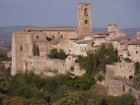
| Casole d'Elsa |
||||
| The Casole area was originally inhabited by the Etruscans. The first written evidence of the town dates back to 896 when Adaberto, a Tuscan marquis, conceded the town to the Bishop of Volterra. The diocese of Volterra ruled over the town for a long time, as confirmed in an 1186 document in which the emperor Enrico VI renewed the concession to the Bishop. At the start of the thirteenth century, Casole gained its independence and became a free town able to elect its own town council. For many years the territory was fought over by Sienese, Florentine and Volterran forces. In 1259 the town was occupied by the Florentine army but following the battle at Montaperti and the Castelfiorentino treaty of 1260, it was definitively brought under Sienese rule. The town’s defensive walls were built by the Sienese during this period. The fortress and the defensive walls are still visible today, although the town gates have unfortunately been destroyed. The southern gate was destroyed by German mines during the Second World War. Main attractions are the church of Santo Spirito and Palazzo Pretorio (the ancient seat of the town council) which is decorated with the terracotta family crests of the town’s various mayors over the centuries. Also of interest are the Palazzo Casolani-Berlingheri-Scheggi, the Collegiata of Santa Maria Assunta and the church of San Pietro and San Niccolò. The Collegiata is home to an important fourteenth century funerary monument belonging to Bishop Tommaso d’Andrea. This sculpture is the first example of its kind of a similar sculpture resting on a ‘shelf’ and belongs to afourteenth century Tuscan school of sculpture. |
|
|||
Castelfiorentino |
||||
| Castelfiorentino is situated in an optimous position on the Chianti hills, in the heart of Tuscany. Far back in 1149 the name of Castelfiorentino was given to a castle erected along Via Francigena, on the site where the Roman settlement of Timignano once stood. Enclosed within the fortified castle, set upon a hilltop, was the parish church of Sant' Ippolito (the ancient parish of San Biagio); erected within a second ring of the walls were Borgo d'Elsa and Borgo Nuovo. Frazioni: Cambiano, Castelnuovo d'Elsa, Coiano, Dogana, Fontanella, Granaiolo, Petrazzi |
 Castelfiorentino |
|||
| Certaldo |
||||
Like many other Tuscan towns. Certaldo is divided between its medieval walled town on a hill and the modern residential and industrial suburb spread out below. |
« Certaldo, come voi forse avete potuto udire, è un castello di Val d'Elsa posto nel nostro contado, il quale, quantunque picciol sia, già di nobil uomini e d'agiati fu abitato »
|
|||
| Colle di Val d'Elsa - Dometaia Archeological Park - Etruscan traces along the Via Francigena |
||||
Colle Val d’Elsa is a town on three levels: Borgo, which is accessible through the majestic Porta Nuova and is made up of beautiful 16th and 17th century patrician town houses; Castello, or Colle Alta, which still retains its original Medieval appearance and is the town’s religious and political centre; and Piano, or Colle Bassa, which is composed of the ancient hamlet of Spugna, where the town’s wool weavers, paper manufacturers and glass craftsmen made use of the nearby river Elsa. In 1592 Colle Val d’Elsa was made a bishopric. |
|
|||
| Gambassi Terme |
||||
| Gambassi Terme is located about 35 km southwest of Florence. Main sights are the church of San Giovanni Battista, in the frazione of Varna, which houses a replica of Andrea del Sarto's Madonna with Child and Saints, the Romanesque Pieve of Santa Maria Assunta (12th century), and the Parco Comunale, former garden of the Villa Sinnai. The Gambassi garden is located between the historical centre and the facility of the Terme di Gambassi (Gambassi Hot Springs). In the past the park shaped the expansive garden of the Villa Sinnai, and still testifies to its elegance and richness. In 1916 the villa was acquired by the Piccoli family, which introduced some exotic plants imported from Africa into the park. Just outside the centre of Gambassi on the road towards Castelfiorentino stands the splendid Romanesque parish church of Santa Maria a Chianni, one of the most significant monuments of Romanesque architecture in the Elsa Valley. The first mention of the parish of Santa Maria a Chianni can be found in a document dated 26 March 988. The basilica design with a nave and two side aisles is grafted on a wide, protruding transept, on the end wall of which there were originally five semi-circular apses. Of particular interest are the four smaller apses made in the depth of the end wall itself, following a design which is also found in the Cathedral of Volterra. Frazioni: Pillo, Borgoforte, Varna, Catignano, Casenuove, Castagno, Badia a Elmi |
 Pieve di Santa Maria Assunta in Chianni |
|||
| Montaione | ||||
| According to some archaeological finds dated back at Etruscan-Roman epochs, the charming village of Montaione has been inhabited from very ancient times. At a few metres from the old town centre you can indeed admire remains of a Roman cistern dated at the II century A.C., as well as some finds of Etruscan china in the area of Santo Stefano. Even the Church of San Biagio, at 500 metres from the village, shows that Montaione was already inhabited in early Christian times, even though some more detailed news about it started from the Middle Ages. In 1118 at a distance of 2 Km from the centre of the town, it was built the “Pieve di San Regolo”: notable example of Romanesque architecture in Tuscany, which nevertheless not correspond to the historical church nowadays located at the very centre of Montaione. Once become commune in 1257, Montaione was involved in the battles among Gimignano, Volterra and San Miniato: battles that deeply marked the Middle Ages in Tuscany. During that period, the Castle of Montaione was ringed by sturdy walls and framed by 11 imposing towers. The urban district, crossed lengthwise by three streets (like every typical Roman camp), enclosed the Church of San Bartolomeo (today dedicated to San Regolo) and Palazzo Pretorio. Montaione is provided with a rich network of trekking paths. The routes are organized along 6 itineraries, planned in order to discover the countryside, exploiting the different areas, woods and slopes. Frazioni: Casetta, Sant'Antonio, Olmo, Filicaja, Le Mura, Gli Alberi, La Sughera, Santo Stefano, Iano, San Vivaldo, Castelfalfi, Barbialla, Collegalli, Tonda, Piaggia, Vignale |
 |
|||
| Montelupo Fiorentino | ||||
| Montelupo Fiorentino is the centre of the production of Florentine majolica. The territory of Montelupo Fiorentino was inhabited from time immemorial thanks to its fruitfulness, to the abundance of water and to its strategic geographical position (a natural crossroads on the communication route between the Apennines and southern Tuscany). Montelupo was probably founded at the end of the Early Middle Ages with the construction of a castle. Towards the end of the 14th century AD, Montelupo Fiorentino (who never had the name of Malborghetto, a real romantic invention) became a "walled village" of the Florentine countryside. The walls were built in 1348 (the year of the Black Death), and the Statute of the Powers dates back to 1414. Until the 16th century AD, Montelupo Fiorentino lived his golden age. In mid 17th century AD, due to the plague that hit the area hard, a period of decline began, and irreversibly Montelupo Fiorentino was led to a drastic restructuring, which reached its peak in the late 18th century AD. Since then and until World War II, Montelupo Fiorentino found himself on the border of everything. The country was shaken in the last half of the 20th century AD by some catastrophic natural events in nature. Most important are the floods of 1949,1966 and 1992. In these three events in fact, the Arno River north of Montelupo Fiorentino, and the Pesa River adjacent, flood submerging the country below four meters of water (two meters in 1992). The remains of the old castle of Montelupo with an imposing tower are still visible on the hill which overhangs the built-up area. The 16th-century well, Baccio da Montelupo’s (and his brother’s, Raffaello Sinibaldi) native house and the Priory of San Lorenzo are still visible, too. Near the castle we find the parish church of San Giovanni Evangelista, which holds the most famous painting in the whole territory: La Madonna con Bambino e Santi of the school of Botticelli. Nearby we find the portico and the loggia of Palazzo del Podestà (which is today the seat of the Museo Archeologico e della Ceramica, Archaeological and Ceramics Museum), which are decorated with majolica heraldic insignia. In the nearby site of Ambrogiana we also find a remarkable large villa built by the Medici’s family on the left bank of the Arno at the end of the 16th century. Frazioni: La Torre, Ambrogiana, Botinaccio, Camaioni, Citerna, Erta, Fibbiana, San Quirico, Samminiatello, Sammontana, Pulica, Turbone Comune | www.comune.montelupo-fiorentino.fi.it |
||||
| Montespertoli |
||||
The Montespertoli area has always been directly involved in the history of Florence. The lands of the Borough of Montespertoli have always played a crucial role, since the ancient Etruscan age, thanks to their road network that helped Florence trade with Volterra and Siena along the Via Volterrana, which crossed the borough of Montespertoli from north to south and joined the Via Francigena near Certaldo. |
|
|||
| Poggibonsi |
||||
| Its origins are ancient, and ruins have been foudn that can be traced back to Late Roman times, as well as Lombard and Carolingian times. In early Middle Ages, the presence of Abbey of San Michele Arcangelo in Poggio Marturi led to the growth of the village of Marturi. In Poggibonsi, it is worth visiting the Archaeological Park and the Fortress of Poggio Imperiale, created and designed by Giuliano da Sangallo on a commission of Lorenzo de' Medici. Frazioni: Staggia Senese, Bellavista |
||||
| Radicondoli |
||||
| Nel XIII secolo la popolazione di Radicondoli aumentò a causa dello sfollamento di molti villaggi circostanti che qui vi si trasferirono. Al tempo il borgo era già una fiorente città con edifici amministrativi e religiosi, l’intera comunità era legata al fiorente sviluppo economico legato principalmente alla lavorazione della lana. Il castello fu costruito nei primi del 1200, conoscendo il suo massimo splendore tra la metà del XIII e XIV secolo. Il paese fin dalla nascita appartenne alla famiglia dei Conti Aldobrandeschi, fino al 1230 quando passò sotto il dominio di Siena, per rimanervi fino a quando su compresa nel Granducato di Toscana. Dopo un lungo periodo di decadenza, nel 1656 Radicondoli contava soltanto 364 abitanti, si ebbe nel corso del Sette-Ottocento una moderata ripresa. E' a questo periodo che risalgono, infatti, numerosi edifici. Le attività principali, in passato furono l’agricoltura e la pastorizia, anche se ebbero un grande sviluppo le attività artigianali. Nel XIII secolo fu attestata anche la presenza di una corporazione di lanaioli. Durante il Settecento si sviluppò anche una fabbrica di terraglie, mentre nell’Ottocento si confezionavano cappelli di feltro e vi filavano lino e canapa. Frazioni: Belforte |
||||
| San Gimignano |
||||
| The area of Aiano-Torraccia Chiusi has been known since the beginning of the twentieth century. There is a Roman structure that has recently come to light: it is a Roman villa of the wealthy aristocracy that was in use between the fourth and sixth centuries AD, and until the second half of the seventh century. A.D. The importance of the structure is proof of a strong and prestigious presence of Romans from Late Antiquity. It is also important for its position along the Foci river, an area long ago identified as the possible area identified by Sigeric in his journey from Rome to Canterbury (Sce Martin Fosse). Get there with the road from San Gimignano to Poggibonsi, just before the intersection with Colle Val d'Elsa, in the direction of Monti-Torraccia Chiusi; follow the dirt road and continue to walk to the archaeological area (about 2000 m.). Frazioni: Ulignano, Badia a Elmi - Canonica, Castel San Gimignano |
 San Gimignano, viiew from Rocca di Montestaffoli |
|||
| The Poppiano Castle or Castello di Poppiano was an imposing medieval building with three rings of walls, built around the year 1000. It was used as a fortress for the external defense of Florence and, as testified by an inheritance document of 1199, it has belonged to the Guicciardini family for at least nine centuries. During this long period, it has been the center of many episodes linked to the history of Florence. Among the most remarkable events, in 1369 John Hawkwood, the famous English Soldier of Fortune, who had just fought the battle of Fosso Armonico, near Cascina, set up his camp in the Poppiano Castle. The Castle was partially destroyed in 1529 during the siege of Florence, as mentioned by Francesco Guicciardini in his 'Memorie'. Despite still showing its ancient magnificence, the structure of the castle, as we see it today, bears evident signs of the renovation that followed the destruction caused by an earthquake in 1812 and that was carried out on the basis of frescoes from other Guicciardini villas in Val di Pesa and Val d'Elsa, which depicted the original structure of the castle. Address: Via Fezzana, 43, 50025 Poppiano Frazioni: Montagnana, Baccaiano, Martignana, Ortimino, Montegufoni, San Quirico, Lucardo, San Pancrazio, Anselmo |
 Castello di Poppiano |
|||
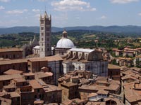
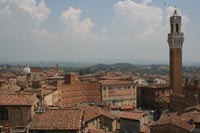
| Siena |
||||
| Siena is universally known for its artistic and cultural heritage, in addition being famous for its Palio held each year in the Piazza del Campo. Founded by the Romans, today the city still retains its medieval appearance with its cobblestone streets, its small squares that are hidden away, its towers, and its palaces. The heart of the city radiates from Piazza del Campo, the most famous piazza in Siena. Here is where the Palio takes place and here are the city's most important monuments: the Palazzo Comunale (City Hall), built between 1298 and 1310; and the Torre del Mangia (the Mangia Tower), 102 meters high, offering a magnificent view that overlooks the city and the surrounding countryside. Among the important monuments is the Duomo, a beautiful building in the Roman-Gothic style with a façade of green and white marble. The Palio is the most important event in the city: it is held July 2 and August 16 in the Piazza del Campo. The event draws tourist from all over the world and is broadcast live on many television stations. |
Siena, duomo |
|||
 |
||||
Podere Santa Pia, April |
||||
The stone hamlet of Castiglioncello Bandini crowns one of the rolling hills of the Maremma area of Tuscany and still maintains an old-fashioned, rural way of life. Podere Santa Pia is situated in an extremely panoramic position with expansive views overlooking the Valle d'Ombrone. The primitive and unspoilt nature of the Maremma surrounds you, and the emotion provoked by such a suggestive landscape will open up previously-unknown sensory horizons inside you.
|
||||
|
||||