| |
|
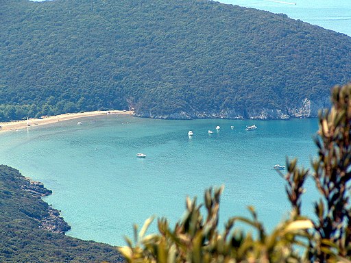
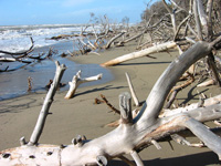
The Maremma Park, with its range of hills descending towards the sea to reach the sandy beaches and cliffs, was established in 1975 and spreads from the mouth of the Ombrone river till it reaches Talamone, along 25 km of the breathtaking Tuscan coastline surrounded by marshland, pinewood forests, tilled land and pastures. The Maremma Park extends over a rectangular area of 100 square kilometers, and borders in the south and southwest with the sea, facing it in the southern part with a high coast subject to erosion. This kind of coast is followed in the north by beaches where the vegetal covering consists of several pioneer species which can adapt to the difficult sandy and brackish environment and which are replaced by typical species of the Mediterranean maquis as you leave from the shoreline.
From a naturalistic point of view, the complex formed by Uccellina Mountains, the pinewood of Marina di Alberese, the mouth of the river Ombrone, and the Paludi della Trappola represents a precious mosaic of ecosystems shaped by man in different periods and ways, characterizing the landscape without degrading it.
There are
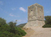
eight medieval towers built there by Cosimo I di Medici. At Poggio Lecci you can see the ruins of the Abbey of San Rabano, built in the eleventh century and dismantled by the Sienese in the fifteenth. Down below there are caves which were inhabited in prehistoric times.
|
|
 |
 |
Torre della Trapola near Principina di Grosseto [2]
|
Those who come from the North, leave the Aurelia Road ( via Aurelia) at approximately seven kilometres before Grosseto, by taking the exit Rispescia-Alberese-Parco Naturale della Maremma. Carry on for a few kilometres on the Alberese provincial road up to Alberese. Those who come from the South, turn off at km 166 of the Aurelia Road, and then take the motorway crossing for Alberese- Parco Naturale della Maremma. Carry on for a few kilometres on this road which crosses the picturesque Tuscan countryside, and you will soon get to Alberese where the Visitor Centre of the Park ( Centro Visite del Parco) is situated.
In the North of Ombrone
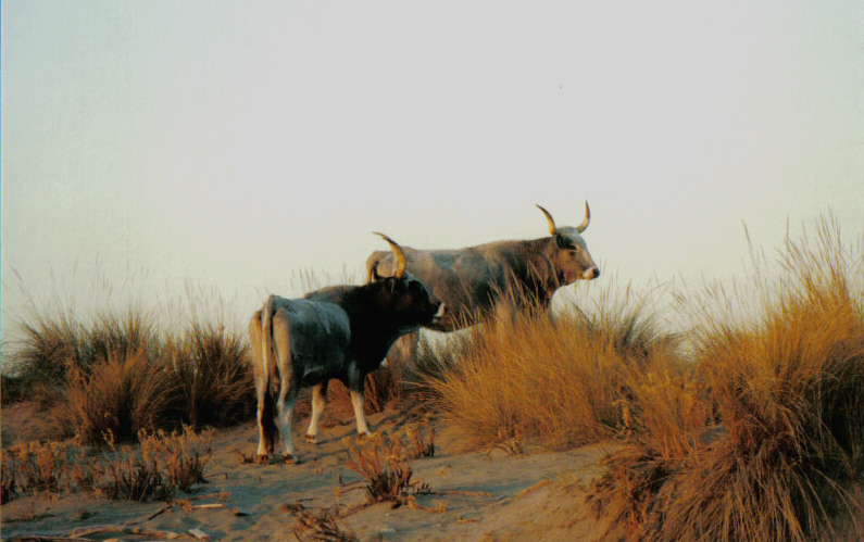
There is a plain covered by Paludi della Trappola: that is a system of stretches of water, partly seasonal and partly permanent (the so-called "chiari" or "bozzi") alternating with not very evident dunes. A typical feature of this Park area is the presence of Maremma cattle bred in a wild state all year round. The inland waters house several migratory aquatic birds during the winter, but other avifauna species live here all year round. The farthest lands from the see have been subject to reclamation activities, and are now covered by agricultural fields and modern zootechnical breedings. The territory described forms part of the delta of Ombrone, a stretch of which cuts with meanders the Park territory.
On the Left of the Mouth of Ombrone
On the left of the mouth of the river Ombrone there is a territory characterized by a compact system of dunes alternating with marshy grounds of limited size and mainly covered with a pinewood. The Stone Pine wood is separated from the sea by a strip of Maritime Pines having the function to protect the territory from the harmful action of the salty winds. This area is crossed by some artificial canals dating back to the 18th-century first land reclamations.
The Park Central and Southern Area
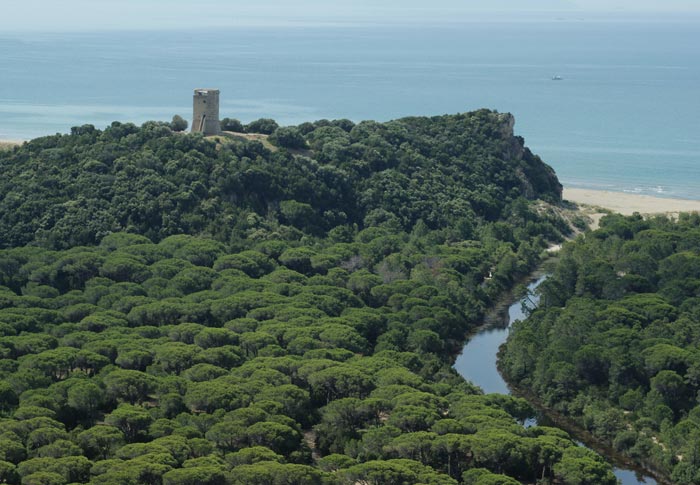
The central and southern Park areas are dominated by Monti dell'Uccellina, is a system of mountains, partly of calcareous nature and partly siliceous, reaching the 417 meters of Poggio Lecci. These mountains are today almost completely covered with a thick forest vegetation (Mediterranean maquis). Only the lower part of the slopes has been deforested and transformed into olive grove or pasture. On Uccellina Mountains there are ancient religious towers and buildings witnessing the past human presence and activity in the area: the Abbey of San Rabano - which is very damaged - and the towers of Castelmarino, Collelungo, Cala di Forno, and Bella Marsilia.
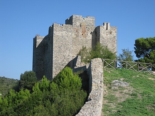
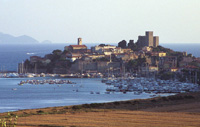
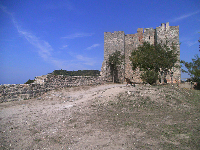
Talamone stands on a little promontory, dominated by an ancient Sienese fortress, to the extreme south of the Monti dell'Uccellina. There are the remains of a Roman villa, while in the caves forming at the foot of the calcareous cliffs some prehistorical evidences dating back to the Paleolithic period have been found.

|
 |
|
 |
|
 |
Cala di Forno
|
|
|
|
Parco Naturale delle Maremma, spiaggia
|
 |
|
 |
|
 |
Talamone, Rocca Aldobrandesca
|
|
Torre del Cala di Forno |
|
Swamps near Ombrone River (Tuscany
|
The Park is open all year round, all week.
To enter, purchase tickets at the entrance at the Visitor Center. It is possible to take a tour on your own or in a group, with a guide or not, depending on the time of the year.
To enter the Park, purchase tickets at the entrance at the Visitor Centers.
The Visitor Centres of the Park (Centro Visite del Parco) are situated in Alberese and in Talamone.
Alberese Visitor Center
Via del Bersagliere, 7/9 - Alberese (Gr)
Tel. +39 0564 407098 - Fax. +39 0564 407278
Open every day including holidays with the following timetable: from October 1 to March 22, 8.30 a.m. to 1.30 p.m.; from March 23 to September 30, 8.00 a.m. to 5.00 p.m.
Visitor Center and Talamone Aquarium
Via Nizza, 12 - Talamone (Gr)
Tel. +39 0564 887173 - Fax. +39 0564 887173
Open every day including holidays with the following timetable: from September 1 to June 30, 8.00 a.m. to 1.00 p.m.; from July 1 to August 31, 8.00 a.m. to 12.00 noon and from 5.00 p.m. to 8.00 p.m.
More info
|
|
Talamone
 Talamone, La rocca senese (sec.) Talamone, La rocca senese (sec.)
|
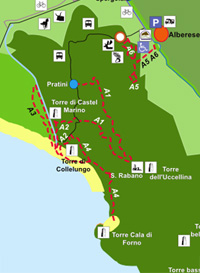
A1 - San Rabano | Departure: from Pratini | 7,2 km, 3.30 hours
It is a spectacular itinerary for the wonderful views it offers and for the presence of an abbey at half of the itinerary. It presents some difficulties linked to the morphological features of the itinerary itself. The ascent you will find at the beginning covers a difference in height of about 300 meters and is accessible to everyone by taking the necessary precautions.
A2 - The Towers | Departure: from Pratini | 6 km, 3 hours
It is a short itinerary accessible to everyone, but it has a steep and slippery descent when you reach the first tower. It is considered the most representative itinerary of the Park because it touches all the environments of the protected area offers beautiful views.
A3 - The Caves | Departure: from Pratini | 9,6 km, 3 hours
The itinerary of the caves is different from the other ones, first of all because it is rather easy to go through, and secondly because its main point of interest is the area where the grand-ducal pinewood lies. As a matter of fact, the main points of interest of this itinerary are the pinewood, the Scoglietto - Collelungo canal, and the caves.
A4 - Cala di Forno | Departure: from Pratini | 12 km, 4 hours
It is a demanding itinerary not only for the harshness of the territory, but for its length: as a matter of fact, it does not present uphills or descents and it has not dangerous locations. If you are well-trained, you can finish the itinerary in a shorter time with respect to the scheduled one.
A5/A6 - Dedicated to fauna and forest | Departure: from the Church in Alberese, on the left of the façade | 6 km, 2 hours
The itinerary dedicated to forest and fauna is a didactic itinerary developing on an area of about forty hectares. It mainly develops on a level ground, at intermediate altitude on the hill facing Alberese. It does not present any difficulty and it has been partly equipped for disabled people.
A7 - Mouth of the river Ombrone | Departure: from the parking area in Marina di Alberese, go back for about 500 meters up to a little bridge. From here take a secondary asphalt road (close to the traffic) going northwards | 5 km, about 2 hours
The itinerary leading to the mouth of the river Ombrone is without a doubt one of the most interesting itineraries in the Park. An easy and entirely flat route, 50% of which developing along an asphalt road and suitable for everyone, also for disabled people.
A8 - Macchiozze| 500 meters, about 1 hour
T1 - Punta del Corvo | about 3 kms, about 2 hours
The itinerary starts from the Visitor Center of the Caprarecce. A slightly uphill road surrounded by dry vegetation leads us to an area characterized by a higher vegetation until you reach the almost flat ridge itinerary. The route continues up to a panoramic area called Punta del Corvo, where there is a covered-roof terrace giving the opportunity to enjoy a wonderful view over the coast and some islands of the Archipelago Toscano.
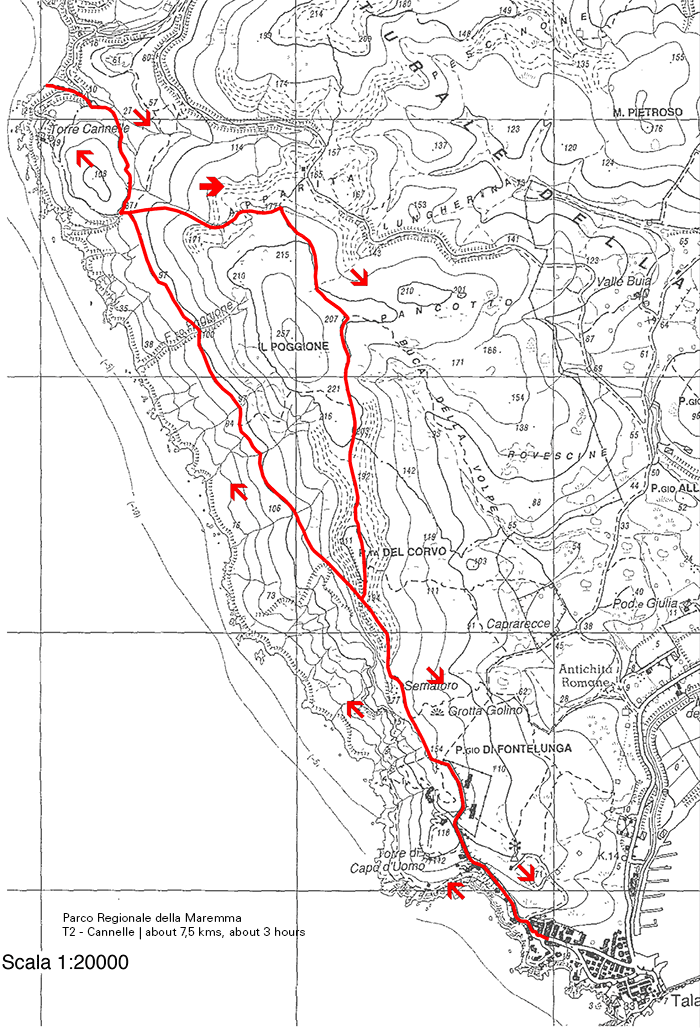
T2 - Cannelle | about 7,5 kms, about 3 hours
The departure of this itinerary takes place from the Visitor Center of the Caprarecce. After a slightly uphill road surrounded by dry vegetation, you will enter an area characterized by a higher vegetation (an ilex grove artificially maintained in a shrub state with periodical cuttings) until you reach the ridge itinerary near the location Punta del Corvo.
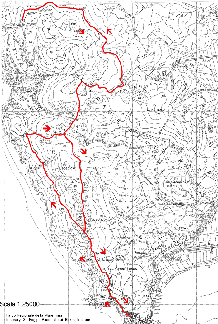
T3 - Poggio Raso | about 10 km, about 5 hours
Also this itinerary leaves from the same departure point of T1 and T2, that is from Caprarecce, but T3 develops in its initial part along the stretch used in the other itineraries for the return. It is characterized by uphill stretches, in particular as far as the final one is concerned, until you reach the ridge.
P1 - Birdwatching Chiari della Trappola | about 2,5 km, about 2 hours
It is a very easy itinerary, mainly developing on level ground. It can be gone through only during the winter and with guided visits.

|
|
Parco Naturale della Maremma
T1
T2
|
Cycling in Tuscany | The Maremma Park
Rispescia - Ponti Neri - Barbicato - Molinaccio - Alberese - Centro Visite Parco della Maremma - Loca lità Spergolaia - Marina di Alberese - Foce dell’Ombrone - Loca lità Spergolaia - Canale Essiccatore - Antica Dogana - Giuncola - Rispescia

|
|
|
This site provides interesting information and itineraries.
Parco Naturale della Maremma | www.parks.it | Map | Itineraries | (Eng) (Deutsch) (It)
Walking in Tuscany | Parco Regionale della Maremma | From Alberese to San Rabano and Cala di Forno
Tuscany Beaches in Maremma | [1] From Principina a Mare to Piombino
Tuscany Beaches in Maremma | [2] From Principina a Mare to Ansedonia
Maps are available in Podere Santa Pia
We suggest Kompass 651 (2005), Maremma, Argentario, Grosseto, Isola del Gigilo 1 : 50 000.
Edizioni Multigraphic, Parco di Montioni - Alta Maremma 1 : 25 000.
|
|
A8 - Macchiozze
Marina di Grosseto |
Noticeable features in the heart of the Monti dell'Uccellina are the watchtowers, some in ruins, built to prevent the attacks of the corsairs. These fortifications formed a series of lookout posts linked to the forts of Castiglione dell a Pescaia and Talamone. The campanile of San Rabano and the remains of the abbey are, however, a reminder that as early as the 12th century Benedictine monks attempted to colonize these rugged hills. All around, the limestone rocks descending steeply to the sea are thickly covered with macchia Mediterranean consisting of the holmoak, myrtle and the strawberry and mastic trees. The rare European fan palm (Chamaerops humilis) grows on the cliffs. The fauna is very varied: the wildcat and porcupine - its long black quills may be noted on the ground - still live undisturbed here. But the uncontested monarch of the macchia of the Uccellina, and the rest of the Maremma, is the wild boar.[1]
|
| |
|
|
|
| |
|
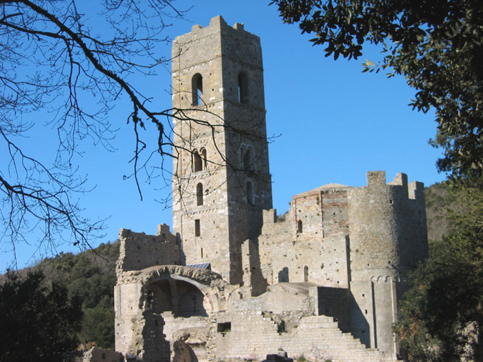
At the heart of the Uccellina Park, in a splendid panoramic position overlooking the Cala di Forno, stand the ruins of the ancient abbey of San Rabano, founded by Benedictine monks in the 11th century.
In the course of the next two centuries the abbey was enlarged and fortified: the original structure of the three-apsed church built on a Latin cross plan was extended in the 12th century with two areas either side of the church's nave and the bell-tower was raised, whose mighty bulk is refined by windows with single and double lights. The fortification of the entire complex, on the other hand, dates back to the early 14th century. After tenacious attempts by the monks to exploit the surrounding terrain over the centuries, the abbey was abandoned once and for all in the 17th century. The atmospheric ruins were only recently torn from the dense vegetation that had almost suffocated them for good.
|
|
Buoi maremmani
|
Buttero, an epic trade and Maremma’s ultimate symbol
|
| |
The name of Alberese first appears in the XIth century, when the Benedictine Abbey of Santa Maria Alborense was founded, subsequently called San Rabano and destined to dominate the history of the entire area for the fifty years which followed. With the crisis of the monastic order, the Abbey fell into decline, and its long history closes with the passage of the Knights of Malta. In 1470, Beuccio Capacci, prior of the order, had a fortified building constructed which today is the Villa Fattoria Granducale which overlooks the town.
At the end of the 1500's, rule passed to the Medici family, up until the coming of the Corsini, in 1740, who, in 100 years, reduced the town to quite desperate conditions. It was then that, in 1839, Leopoldo II of Lorraine decided to purchase the Alberese estate and to undertake the work of reclaiming and developing the lands which had now become marshland, of improving the equipment and introducing new methods of cultivation. This, until the First World War broke out and following which, the holdings of the Lorraine, administered by the duke Pietro Lante della Rovere, were confiscated and passed to the State. Finally, in 1926, Alberese was ceded to the Opera Nazionale Combattenti (the Military Veterans association) which, during the fascist period, finished the reclamation work, dividing the land into lots and building farms which were then assigned to families of share-croppers, the most of whom came from the Veneto region. In 1977, this association was abolished and the lands were purchased by the Region of Tuscany, which, still today, administers them.
|
Talamone, a picturesque and solitary fishing village,stands on a little promontory, dominated by an ancient Sienese fortress, to the extreme south of the Monti dell'Uccellina. In antiquity Talamone was an Etruscan port.
At the top of the rocky hill you can see a wonderful view, following the coast line of Osa, you see right up until the promontory of Argentario (about 30 minutes by car) with its jagged coast, its coves with crystal clear sea.
A zone that will leave a lasting charm and certainly unforgettable, also appart from it being interesting, this a very popular destination for skin diving as in the depths of the sea there are beauliful sealife views (for more information: The Argentario Coast Diving Centre).
Near to Talamone is the spa of Osa. Here, a spring of suphureous water with a temperature of 32°C is exploited for the therapeutic purposes. The virtues of the waters of Osa have been renowned since time beyond recall. They were in use in Roman times and remains of buildings equipped for thermal cures have been excaved in the zone known as Bagno dell'Osa as well as in the Le Tombe district.
According to a legend handed down from classical literature the eponym of this town was Telamone, the son of Eaco, who landed here with the Argonauts by coming back from Colchide. The Grecian hero died here and was buried under the promontory.
An important archaeological discovery made on the Talamonaccio hill concerns some fragments of Etruscan sculpture, which dates back roughly to 150 b. C. and in which is represented the final act of the Edipo’s curse during the war of Seven years against Thebes. This subject represented for the Etruscans the end of their history.
The local beach of Talamone has become a very popular area to practice the sport of Kitesurfing. Among the monuments of interest is the fortress which stands out from the promontory, overlooking the entire village, the Chiesa della Madonna delle Grazie and the Chiesa di Santa Maria Assunta?
Le spiagge più belle della Toscana | La costa, le spiagge e il mare della Toscana naturista
Tuscany's Best-Kept Secret | Holiday home Podere Santa Pia
Film | Dream of Italy, episode one (the butteri (cowboys)
The last of the Tuscan cowboys | ELIZABETH SALTHOUSE | JUNe 30, 2017 | www.italoamericano.org
Maremma, southern Tuscany, is a timeless region with ancient roots. People have thrived here for centuries. From the Etruscans to the Medicis to today’s modern Tuscans all have left their mark. And its here, amongst the green hills, flat marshes and secluded beaches of the national park that you have the chance to glimpse the horseback butteri of Maremma; the last of the Tuscan cowboys.
|
Map Parco Naturale della Maremma
|
|
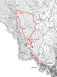
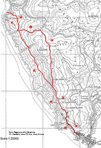
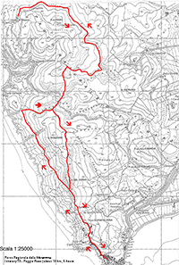
Watch map with the main itineraries in the Parco Naturale della Maremma
|
The territory around Orbetello is extremely varied. The lagoon's wetland is divided into two pillows by the sea (il Tombolo della Feniglia and Tombolo della Giannella) characterized by long sandy beaches, pinewood forests and Mediterranean bush, while next to the Talamone and Ansedonia heights, the coastline is full of cliffs. The hinterland offers lower heights and vast plains where cultivations alternate with Mediterranean bush.
After the Medici defeated Siena in 1557 Orbetello became the capital of the Stato dei Presidi under Spanish rule. The Spanish transformed it into an important naval base and realized various fortifi ed structures which still characterize the entire territory.
Orbetello is joined to the Argentario promontory by two long, golden sand dunes, known as the Tomboli della Feniglia e della Giannella that offer the visitor kilometres of enchanting, unspoilt beaches.
Spiaggia Feniglia. This impressive beach is 7 km long and it has fine white sand and is backed by a lush pine forest. It ends with the lagoon of Orbetello. It can easily be reached from Porto Ercole.
|
The islands of the Tuscan archipelago
|
| |
The islands of the Tuscan archipelago, a nature sea park, and an extraordinary place for the beauty of its depths and the cleanliness of the seawater. The Isles known as Giglio and Giannutri in particular are not to be missed.
[read more] |
|
| |
|
|

[1] Source : Toscanamare | www.touringclub.it
[2] Photo by LigaDue, licensed, licenziato in base ai termini della licenza Creative Commons Attribuzione 3.0 Unported
|
|
|


 Talamone, La rocca senese (sec.)