| |
|
| |
|
|
|
|
|
|
| |
 |
|
Walking in Tuscany | Parco Regionale della Maremma | From Alberese to San Rabano and Cala di Forno
|
|
 |
 |
| |
|
|
|
| |
|
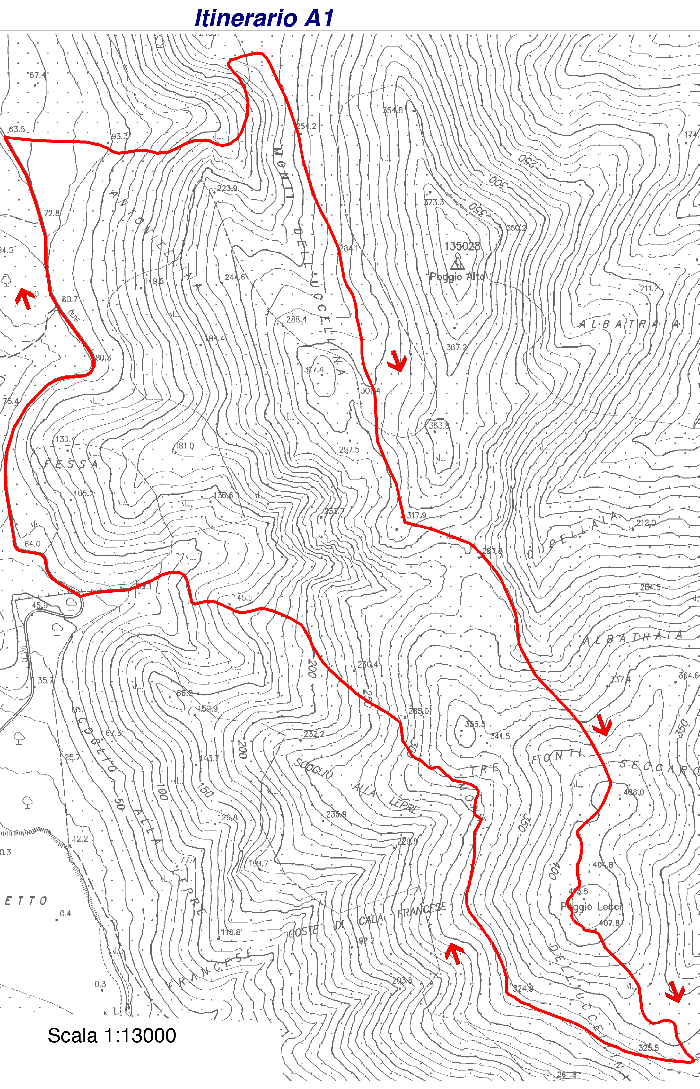
| A1
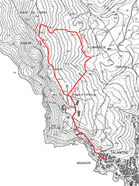
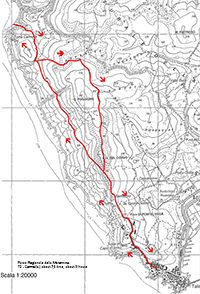
From Alberese to San Rabano | Departure: from Pratini | 7,2 km, 3.30 hours |
|
|
|
This excursion is not particularly difficult, only 6 km long over a descend of 400 m, it should take only half a day. The itinerary climbs up to the heart of the Uccellina mountains.
From Alberese, where you can leave your car, you reach Strada degli Olivi which, bending to the left in the direction of the sea, will take you to Pratini. From here, your walk will be in the shade even on the hottest of summer days, and you can start your ascent up the crests of the Uccellina hills. If you observe carefully you can spot tracks of the many animals living in the park, but a 'close encounter' with one of them will be difficult because these animals have nocturnal habits and are shy: pole-cats, weasels, porcupines, badgers, and wild boars. There are numerous protected species of vegetation, like the rare dwarf fan palm.
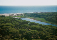
After only a few miles, once you have reached Poggio Leccio you will be able to enjoy a spectacular panoramic view over the plateau and mouth of the river Ombrone, spanning all the way to the sea.
Farther out the forest suddenly gives way to a glade and the whitish stones of the Abbey of San Rabano Benedictine Monastery (XI cent.) will appear in front of your eyes. Among the Romanesque ruins of the ancient church is a standpoint that you'll find very difficult not to appreciate because of the scenery all around it. Once you have had a rest, you are ready to return to Pratini.
Download map |
|
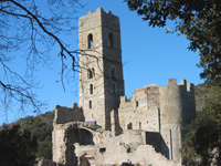
Abbazia di San Rabano

|
|
|
|
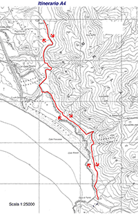
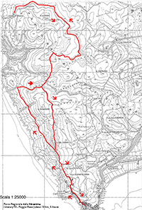
From Alberese to Cala di Forno | Departure: from Pratini | 12 km, 6 hours |
|
|
|
Trail A4 is the longest, most varied, and least used of the trails, taking in hill, coast and cliff scenery, and reaching the large Cala di Forno headland that dominates the bay to the south. The return takes you along me dunes and a superb stretch of beach at Portovecchio.
From Alberese you reach Pratini and the walk takes you onto shady paths to high cliffs, culminating in the Punta di Collelungo. The trail passes through an area covered with typical Mediterranean coastal vegetation, with various bushes like the strawberry tree and aromatic plants, which fill the air with oregano and liquorice fragrances. A little bit of mystery surrounds the area of Punta di Collelungo, a haven over the centuries for Etruscan seamen, smugglers, and barbarous pirates. If you look up you can see the wide circles made by the falcons looking for prey; if you look even further, on a fine day, you can see the coasts of the Isola del Giglio.
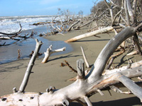
From the cape you descend towards the bay of Cala di Forno and strolling along a wide beach, which entices you to dive in the waves of the Tyrrhenian sea, you head back to Patrini. The pines come right down on the beach, and in places into the sea itself, their smooth, bleached trunks creating the impression of a tropical island.
The Park is open all year round, all week.
To enter, purchase tickets at the entrance at the Visitor Center in Alberese or Talamone. It is possible to take a tour on your own or in a group, with a guide or not, depending on the time of the year.
Download map
Alberese, Parco dell'Uccellina fino a cala di Forno e ritorno | 12,7 km
|
|

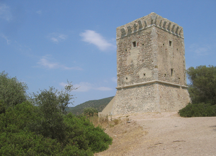
Torre di Collelungo
|
|
|
|
The Visitor Centres of the Park (Centro Visite del Parco) are situated in Alberese and in Talamone.
Alberese Visitor Center
Via del Bersagliere, 7/9 - Alberese (Gr)
Tel. +39 0564 407098 - Fax. +39 0564 407278
Open every day including holidays with the following timetable: from October 1 to March 22, 8.30 a.m. to 1.30 p.m.; from March 23 to September 30, 8.00 a.m. to 5.00 p.m.
Visitor Center and Talamone Aquarium
Via Nizza, 12 - Talamone (Gr)
Tel. +39 0564 887173 - Fax. +39 0564 887173
Open every day including holidays with the following timetable: from September 1 to June 30, 8.00 a.m. to 1.00 p.m.; from July 1 to August 31, 8.00 a.m. to 12.00 noon and from 5.00 p.m. to 8.00 p.m.
Park visits during the Summer (June 15 - September 15)
The itineraries A3 - LE GROTTE A4 - CALA DI FORNO and P1 - BIRDWATCHING have been closed due to potential fire risks.
All other itineraries can be toured with a guide after booking, except for itineraries A5/A6 FOREST/FAUNA and A7 OMBRONE RIVER MOUTH which you can plan on your own. Itinerary A2 requires a guide, but not prior booking.
Tours with a German, English and French guide are provided for itinerary A2 The Towers.
Visiting the Park in Springtime, Fall and Winter (September 16 - June 14)
During this part of the year visits are free starting from 9.00 a.m. till an hour before dusk. All itineraries are open.
Walking in Southern Tuscany | Nature reserves and beaches in the Maremma, in southern Tuscany
Maps available in Podere Santa Pia:
Kompass 651 (2005), Maremma, Argentario, Grosseto, Isola del Gigilo 1 : 50 000.
Edizioni Multigraphic, Parco di Montioni - Alta Maremma 1 : 25 000.
|
|
 |
|
|
|
| |
|
|
| |
Other itineraries
A2 - The Towers | Departure: from Pratini | 6 km, 3 hours
It is a short itinerary accessible to everyone, but it has a steep and slippery descent when you reach the first tower. It is considered the most representative itinerary of the Park because it touches all the environments of the protected area and offers beautiful views.
Trail A2 starts nearer the beach and connects some of the medieval watchtowers built by the Spanish, who, with the Sienese, were me only people to bother with the area. it offers an extraordinary view over the umbrella pines (Pinus pinea) on the sand bar and dunes below. These are one of the most memorabIe natural sights in Tuscany, a vast canopy of emerald green that stretches almost as far as the eye can see.
A3 - The Caves | Departure: from Pratini | 9,6 km, 3 hours
The itinerary of the caves is different from the other ones, first of all because it is rather easy to go through, and secondly because its main point of interest is the area where the grand-ducal pinewood lies. As a matter of fact, the main points of interest of this itinerary are the pinewood, the Scoglietto - Collelungo canal, and the caves.
A5/A6 - Dedicated to fauna and forest | Departure: from the Church in Alberese, on the left of the façade | 6 km, 2 hours
The itinerary dedicated to forest and fauna is a didactic itinerary developing on an area of about forty hectares. It mainly develops on a level ground, at intermediate altitude on the hill facing Alberese. It does not present any difficulty and it has been partly equipped for disabled people.
A7 - Mouth of the river Ombrone | Departure: from the parking area in Marina di Alberese, go back for about 500 meters up to a little bridge. From here take a secondary asphalt road (close to the traffic) going northwards | 5 km, about 2 hours
The itinerary leading to the mouth of the river Ombrone is without a doubt one of the most interesting itineraries in the Park. An easy and entirely flat route, 50% of which developing along an asphalt road and suitable for everyone, also for disabled people.
A8 - Macchiozze (Observation Point) | 500 meters, about 1 hour
|
 |
|
 |
|
 |
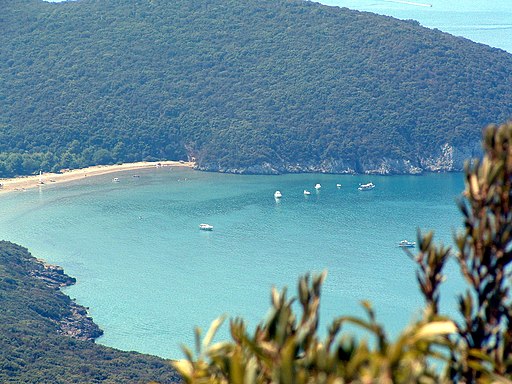
Cala di Forno
|
|
|
|
Parco Naturale delle Maremma, spiaggia
|
 |
|
 |
|
 |
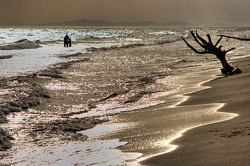
Marina di Alberese, Tramonto sulla spiaggia
|
|
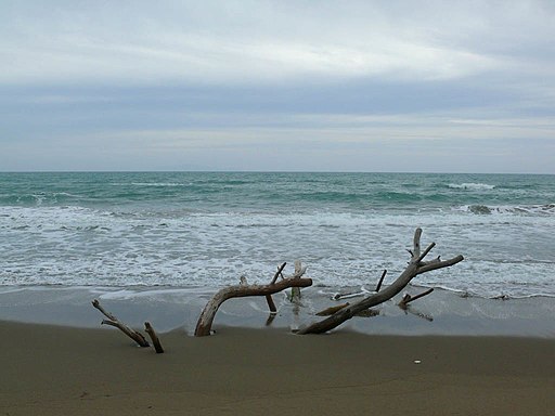
Marina di Alberese, spiaggia |
|
Da Marina di Alberese alla foce del fiume Ombrone |
| |
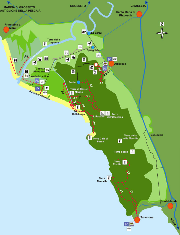
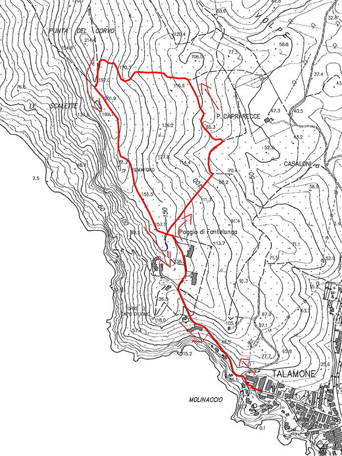
T1 - Punta del Corvo | about 3 kms, about 2 hours
The itinerary starts from the Visitor Center of the Caprarecce in Talamone. A slightly uphill road surrounded by dry vegetation leads us to an area characterized by a higher vegetation until you reach the almost flat ridge itinerary. The route continues up to a panoramic area called Punta del Corvo, where there is a covered-roof terrace giving the opportunity to enjoy a wonderful view over the coast and some islands of the Archipelago Toscano.
Download map
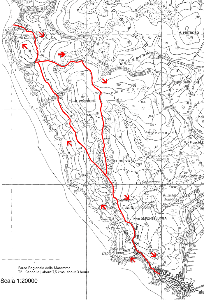
T2 - Cannelle | about 7,5 kms, about 3 hours
The departure of this itinerary takes place from the Visitor Center of the Caprarecce. After a slightly uphill road surrounded by dry vegetation, you will enter an area characterized by a higher vegetation (an ilex grove artificially maintained in a shrub state with periodical cuttings) until you reach the ridge itinerary near the location Punta del Corvo.
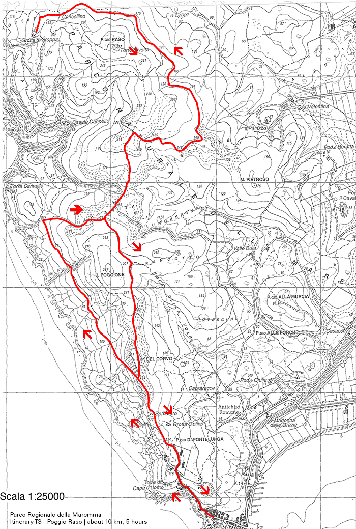
T3 - Poggio Raso | about 10 km, about 5 hours
Also this itinerary leaves from the same departure point of T1 and T2, that is from Caprarecce, but T3 develops in its initial part along the stretch used in the other itineraries for the return. It is characterized by uphill stretches, in particular as far as the final one is concerned, until you reach the ridge.
P1 - Birdwatching Chiari della Trappola | about 2,5 km, about 2 hours
It is a very easy itinerary, mainly developing on level ground. It can be gone through only during the winter and with guided visits.
|
 |
|
 |
|
|
| T1 - Punta del Corvo |
|
T2 - Cannelle |
|
T3 - Poggio Raso |

Trekking Parco Naturale della Maremma | I migliori percorsi nel Parco Naturale della Maremma
Walking in Tuscany | Walking through nature reserves and beaches in the Maremma, in southern Tuscany
Two sites provide interesting information and itineraries.
Parco Naturale della Maremma | www.parks.it | Map | Itineraries | (Eng) (Deutsch) (It)
Parco Regionale della Maremma | www.parco-maremma.it | Itineraries | (Eng) (It)
|
|
|
|
| |
|
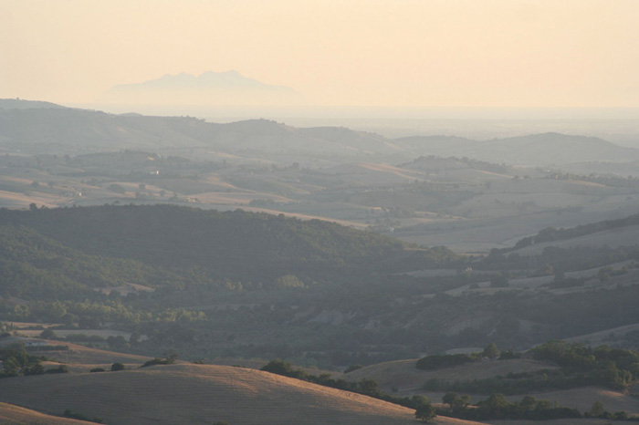 |
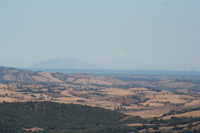
View from Podere Santa Pia (Castiglioncello Bandini) on Valle d'Ombrone, Monte Argentario and the Nature Reserve of the Maremma |
|
|
| |
|
|
|
|
|
|
|
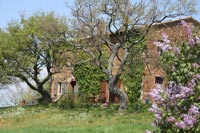
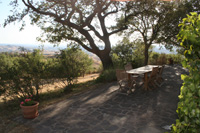
Podere Santa Pia |
|
Podere Santa Pia |
|
 Follow us on Instagram Follow us on Instagram
|
| |
|
|
|
|
|
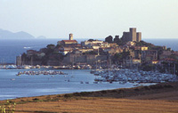
Talamone |
|
The Maremma
Vieuw from Podere Santa Pia up to the coast and Monte Christo
|
|
Principina a Mare
The Ombrone River located along the coast of Maremma Grossetana, where it flows into the Tyrrhenian Sea in Principina a Mare.
|
Talamone, a picturesque and solitary fishing village,stands on a little promontory, dominated by an ancient Sienese fortress, to the extreme south of the Monti dell'Uccellina. In antiquity Talamone was an Etruscan port.
At the top of the rocky hill you can see a wonderful view, following the coast line of Osa, you see right up until the promontory of Argentario (about 30 minutes by car) with its jagged coast, its coves with crystal clear sea.
A zone that will leave a lasting charm and certainly unforgettable, also appart from it being interesting, this a very popular destination for skin diving as in the depths of the sea there are beauliful sealife views (for more information: The Argentario Coast Diving Centre).
Near to Talamone is the spa of Osa. Here, a spring of suphureous water with a temperature of 32°C is exploited for the therapeutic purposes. The virtues of the waters of Osa have been renowned since time beyond recall. They were in use in Roman times and remains of buildings equipped for thermal cures have been excaved in the zone known as Bagno dell'Osa as well as in the Le Tombe district.
According to a legend handed down from classical literature the eponym of this town was Telamone, the son of Eaco, who landed here with the Argonauts by coming back from Colchide. The Grecian hero died here and was buried under the promontory.
An important archaeological discovery made on the Talamonaccio hill concerns some fragments of Etruscan sculpture, which dates back roughly to 150 b. C. and in which is represented the final act of the Edipo’s curse during the war of Seven years against Thebes. This subject represented for the Etruscans the end of their history.
The local beach of Talamone has become a very popular area to practice the sport of Kitesurfing. Among the monuments of interest is the fortress which stands out from the promontory, overlooking the entire village, the Chiesa della Madonna delle Grazie and the Chiesa di Santa Maria Assunta?
The name of Alberese first appears in the XIth century, when the Benedictine Abbey of Santa Maria Alborense was founded, subsequently called San Rabano and destined to dominate the history of the entire area for the fifty years which followed. With the crisis of the monastic order, the Abbey fell into decline, and its long history closes with the passage of the Knights of Malta. In 1470, Beuccio Capacci, prior of the order, had a fortified building constructed which today is the Villa Fattoria Granducale which overlooks the town.
At the end of the 1500's, rule passed to the Medici family, up until the coming of the Corsini, in 1740, who, in 100 years, reduced the town to quite desperate conditions. It was then that, in 1839, Leopoldo II of Lorraine decided to purchase the Alberese estate and to undertake the work of reclaiming and developing the lands which had now become marshland, of improving the equipment and introducing new methods of cultivation. This, until the First World War broke out and following which, the holdings of the Lorraine, administered by the duke Pietro Lante della Rovere, were confiscated and passed to the State. Finally, in 1926, Alberese was ceded to the Opera Nazionale Combattenti (the Military Veterans association) which, during the fascist period, finished the reclamation work, dividing the land into lots and building farms which were then assigned to families of share-croppers, the most of whom came from the Veneto region. In 1977, this association was abolished and the lands were purchased by the Region of Tuscany, which, still today, administers them.
|
|
|
| |
|
|
|
| |
|
|
|
| |
|
|
|
| |
|
|
|
| |
|
|
|
| |
|
|
|

