
 |
|
| I T | Santa Fiora, La Peschiera |
|
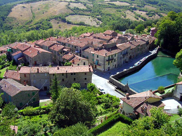
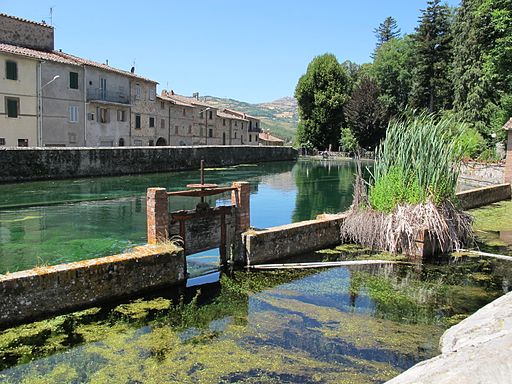
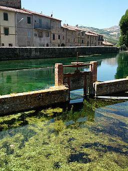
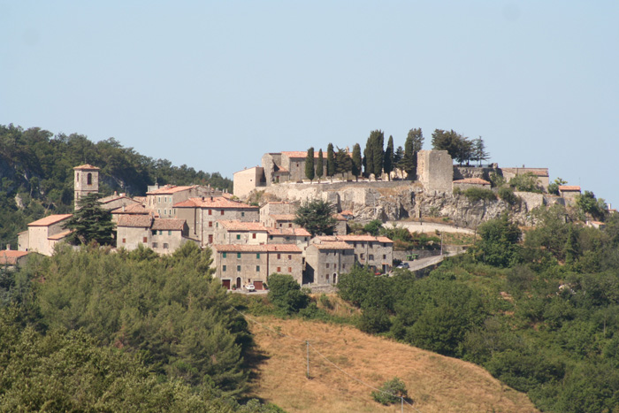
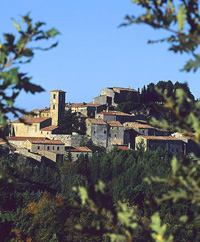
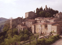
| Santa Fiora, a medieval town situated at the foot of Monte Amiata, is regarded as one of the most beautiful natural environments in Italy. The county of Santa Fiora was a small historical state of southern Tuscany. Together with the county of Sovana, it was one of the two subdivisions into which the possessions of the Aldobrandeschi, then lords of much of southern Tuscany, were split in 1274. Starting from the second quarter of the XIV century, Santa Fiora, however, witnessed an irreversible process of decadence and territorial disintegration which Dante describes in canto VI of the Purgatory: and you will see how dark Santafiora is. The imposing Palazzo Sforza Cesarini was built in 1575 over the Aldobrandeschi Castle, of which two medieval towers can be still seen. The construction of Palazzo Sforza Cesarini dates back to 1571. Today, the building is the seat of the Municipality and is decorated with many wonderful 16th century frescoes. The village has some fine churches. The Pieve delle Sante Flora e Lucilla, reached on Via Carolina from the square, is the principal sacred building of Santa Fiora and dates back to the first half of the 12th century. The church was named after two local saints whose relics were brought here in the eleventh century. Inside you can find extraordinary frescoes and some precious terracotta items, made for the Sforza’s in the 1400’s. A steep lane leads to the Chiesa di Sant'Agostino, which possesses a fine painted wooden image of the Madonna and Child, attributed to Jacopo della Quercia. Down the road you come to gardens and the oratory of Chiesa della Madonna della Neve, (it’s façade is decorated with a wonderful alfresco of Saint Fiora and Lucille) and then to the village's nicest feature, the Peschiera, a spring-fed lake and 18th-century garden surrounded by woodland and gurgling brooks. The Ex- Convento delle Cappuccine, built in the 1600’s, is home to the Crocifisso Miracoloso of the 15th century. Santa Fiora recently received the orange flag by the Touring Club, that rewards sustainable tourism and environmental protection.
|
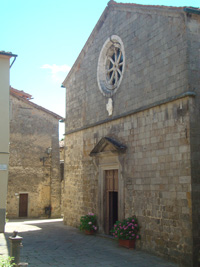 Chiesa della Pieve delle Sante Flora e Lucilla Chiesa della Pieve delle Sante Flora e Lucilla |
|||
 |
||||
Santa Fiora - Veduta della Peschiera e del Terziere di Montecatino [1]
|
||||
| Main events are the Fiera delle Sante Flora e Lucilla, a traditional fair held on July29th, in honour of the patron saints of the town, and the Festa della Madonna delle Nevi, ( a local celebration in honour of the Madonna organized on August 4th. Santa Fiora was chosen as the ideal location for the International Festival Santa Fiora in Musica. Concerto di Ferragosto, a traditional and classical festival organized by philharmonic G. Pozzi, is held on August 15th.
|
||||
| Podere Santa Pia is within easy reach to the main attractions of Monte Amiata. From Santa Fiora you can continue to the medieval centres of Roccalbegna and Semproniano, in the north towards Arcidosso, castel del Piano Seggiano, Vivo d’Orcia and Abbadia San Salvatore. With a sweeping view from 300 meters above sea level, Podere Santa Pia sits on a hill dominating the valleys of the Ombrone and Orcia rivers. In the heart of the Tuscan Maremma, among ancient oak woods, pastures, vineyards and olive trees, the area remains unspoilt, untouched, and rich in natural beauties and in historical and archeological sites.
|
 |
|||
Podere Sata Pia, authentic holiday house in southern Tuscany
|
||||
 |
||||
Santa Fiora, Palazzo Sforza Cesarini (Rocca Aldobrandesca), veduta del retro [2]
|
||||
|
Galleria fotografica Monte Amiata
|
||||
| Santa Fiora
|
||||
 |
 |
 |
||
Santa Fiora
|
La Peschiera di Santa Fiora
|
Santa Fiora, Peschiera |
||
 |
 |
 |
||
Santa Fiora, Peschiera
|
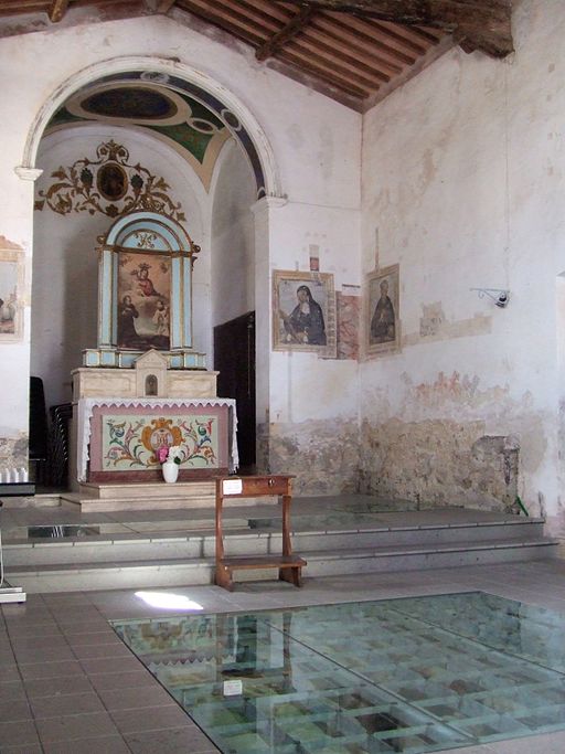
Chiesa della Madonna della Neve- Santa Fiora
|
Interiore della chiesa della Madonna della Neve.Pavimentazione acque trasparenti che mostrano l'origine del Fiora
|
||
Semproniaino
|
||||
 |
||
Semproniano |
||
| Semproniano is situated just 9 km from Terme di Saturnia, in a hilly territory, between splendid scenes and landscapes of the Maremma Tuscany. With its cultivated countryside, waterways and valleys of the rivers Albegna and Fiora, the village deserves to be visited. Main sights are the medieval Palazzo Civico and Palazzo dei Vicari Mediceo, the church of Santa Croce, faced by the remains of the Aldobrandeschi castle (Rocca), the 12th century (renamed in the 16th century) Pieve dei Santi Vincenzo e Anastasio, the castle of Catabbio, built in the 12th century by the Aldobrandeschi and later used by the Orsini of Pitigliano, and the notable medieval burgh of Rocchette di Fazio. The centre of Semproniano, with tight and tortuous roads, was developed in semicircles around the Aldobrandescan Fortress. There is not much left of the fortress, however the panoramic view at Mt. Amiata is worth the trip. Within the ancient and beautiful walls lie the ruins of the Aldobrandeschi fortress, in which only the foundations remain today. Sideways of the fortress, on the square, there is the Chiesa di Santa Croce (Church of Holy Cross), built in the 12th century and a symbol of the town's romantic atmosphere. It has a Roman Gothic style, with a bell tower dedicated to Saint Vincent and Anastasio and a painting of the Rosario on the inside walls. La Pieve dei Santi Vincenzo ed Anastasio (The Parish Church of Saint Vincenzo and Anastasio) is a religious building dating back to the 13th century and home to some splendid frescoes of the 1500's. From Semproniano the road goes almost consistently uphill to the fork between Petricci and Cellena, both routes go to Triana. Comune di Semproniano The municipality of Semproniano contains the frazioni (subdivisions, mainly villages and hamlets) Belvedere (3,50 km), Casa Rigo (4,12 km), Cellena (4,58 km), Il Poggio (3,42 km), Marruchina (2,76 km), Petricci (3,60 km), Rocchette (3,36 km), Rocchette di Fazio (3,41 km), Scalabrelli (5,10 km) and Verziliani (3,78 km). |
 Semproniano Semproniano
|
|
|
||
Itinerari intorno a Santa Fiora, Selva e Monte Amiata | GoogleMaps
|
||
Monte Amiata Vetta - Santa Fiora, Peschiera | 18,10 km | 3h 37m | Download gpx Abbadia di San Salvatore - Santa Fiora | 19,49 km | 4 hours | Download gpx Santa Fiora, Peschiera - Monte Amiata Vetta | 18,16 km | 3h 37m Santa Fiora - Percorso delle Fonti di Selva | 6,6 km | 2h Vetta - Mare | 136 km | 38:02 h | Download gpx
|
||
| Walking in the surroundings of Semproniano, Roccalbegna and the Albegna valley |
||
12 Fonte delle Monache – Marroneto – Santa Fiora | 6 Km/3.7 miles | 2 hours
The local tourist office has produced two very useful booklets (both available for reference at Podere Santa Pia):
|
||
|
|
 |
|
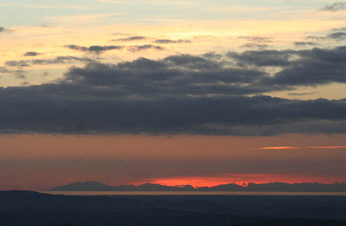
Isola Montecristo and Corsica, view from Podere Santa Pia
|
Bagnolo, Bagnore, Marroneto and Selva are frazioni of Santa Fiora.
|
Visualizzazione ingrandita della mappa |