| |
|
| |
|
|
|
|
|
|
| |
 |
|
 |
 |
| |
|
|
|
| |
|
|
|
|
| |
|
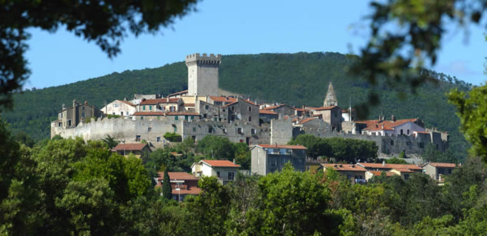
Capalbio has a medieval town plan, with narrow, curved streets climbing to the top of the hill dominated by the Rocca Aldobrandesca. Its natural environment offers spectacular landscapes with lots of green hills and wild beaches and forests.
Capalbio is compietely enclosed within a double set of Sienese walls, along which extensive stretches of the suggestive patrol bays can still be walked. The historical centre can be reached through two entrances: the first is the Porta Senese which still preserves its 15th-century wooden shutters and locks. The other entrance is called Porticina (the small gate).
A nice place to visit in town is La Rocca, L shape building with a big rook and a closed courtyard, dated back Fifteenth Century, when Siena dominated the area. Inside you can still admire the ancient Giacomo Puccini piano.
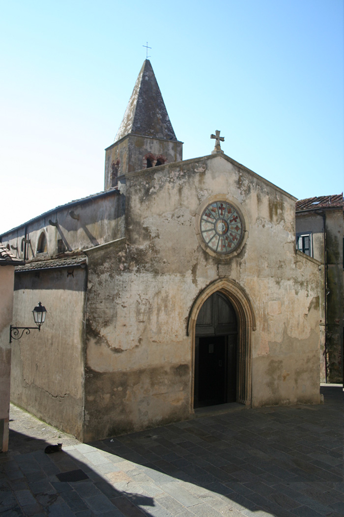
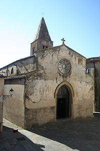
Of great importance is the Romanesque
Pieve di San Nicola which has at its side a bell tower featuring two 12-century rows of mullioned windows with two lights. The Church of Saint Nicholas is not far from the Fortress.
The church's earliest construction dates back to the 12th century, but in 1466 the building was expanded, as is noted on an inscription on the facade. The interior, with a single nave, has massive Romanic capitals crudely carved with designs of vegetables, eagles and imaginary animals.
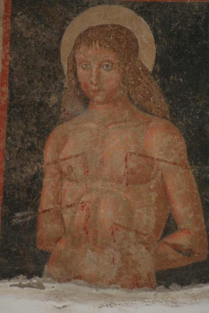
Of interest are the 15th and 16th century frescoes in the chapels on the right which, in the robustness of the figures, show clear evidence of Umbrian pictorial culture.
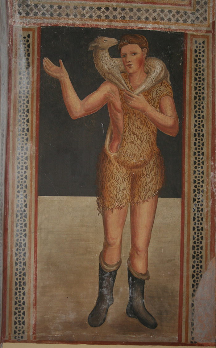
The chapels on the left host frescoes of the 13th century Sienese school.
The origins of the first inhabitants of Capalbio are uncertain. The area was probably already inhabitated in ancient times as some archaic tombs have been found in the nearby Valley of the Fosso della Radicata. This area is mentioned in Livy's Annales and Pliny the Elder's Naturalis Historia. The neighbouring city of Vulci owned these lands from the 8th to the 3rd century BC.
However, the Roman conquest left the deepest traces. Interesting remains are those of the late-republican slave-holding villas, such as the villa of Settefinestre (Seven windows), the villa of the Provincia (Province) and the villa of the Colonne (Pillars). More ruins of villas can be found at Monte Alzato and at Casa Morotti and a Roman necropolis has been located between Burano and the Tagliata. In this area the ruins of Imperial villas can also been seen. Extensive cultivation characterized this period and the large estate caused in time the degradation of the land which was followed by economic decline. In the 4th century AD the area was almost completely abandoned. The barbarian raids started from the middle of the 5th century AD, after the fall of the Western Roman Empire (476 AD). We have scarce, fragmented news of this period. The first signs of revival appeared in the Middle Ages, when the castle of Tricosto and the castle of Monteti (on the homonymous hill) were built on the ruins of an old Roman "castrum". The first document to mention Capalbio is a "privilegium" of Pope Alexander III dated 10th July 1161. This document confirmed the ownership of the Maremman territories which were an integral part of the Abbey estate to Baldinone, the Abbot of the Monastery of the Three Fountains. In the same period the powerful Aldobrandeschi family obtained the entitlement of these lands.
In 1416, after the conquest, Siena wanted to beguile Capalbio to be happy by laying down on its armorial bearings (a bald, cut off head, raised by the claw of an heraldic lion) five Latin hexameters, that D’Annunzio with delight translated in that way: “I am Capalbio, happy, protected from the lion of Siena and from these first walls restored at its own expenses, and from the other walls, that surround the first ones in the year 1416.”
Comune
Ufficio turistico, Via Collacchioni, 1 (tel. 0564.896611)
The walls of Capalbio
|
 |
|
 |
|
 |
Mura di Capalbio
|
|
Mura di Capalbio
|
|
Veduta di un tratto delle Mura di Capalbio |
| |
|
|
|
|
The Church of Saint Nicholas | Chiesa di San Nicola
|
|
|
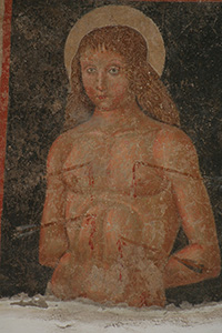
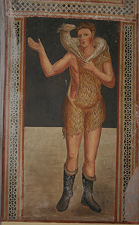
The Chiesa di San Nicola’s construction dates back to the 13th century, which makes it he oldest religious building in Capalbio.
This charming chapel is richly painted with fascinating and colourful religious frescoes. The chapels on the left host frescoes of the 13th century Sienese school.
Of interest are the 15th and 16th century frescoes in the chapels on the right which, in the robustness of the figures, show clear evidence of Umbrian pictorial culture.
(the Saint Sebastian below)
The marble sculpture of a man’s face on the right-hand side exterior wall, is a mask of the Emperor Hadrian (2nd century BC), which is thought to have come from the ancient city of Cosa. |
|
The Church of Saint Nicholas
|
|
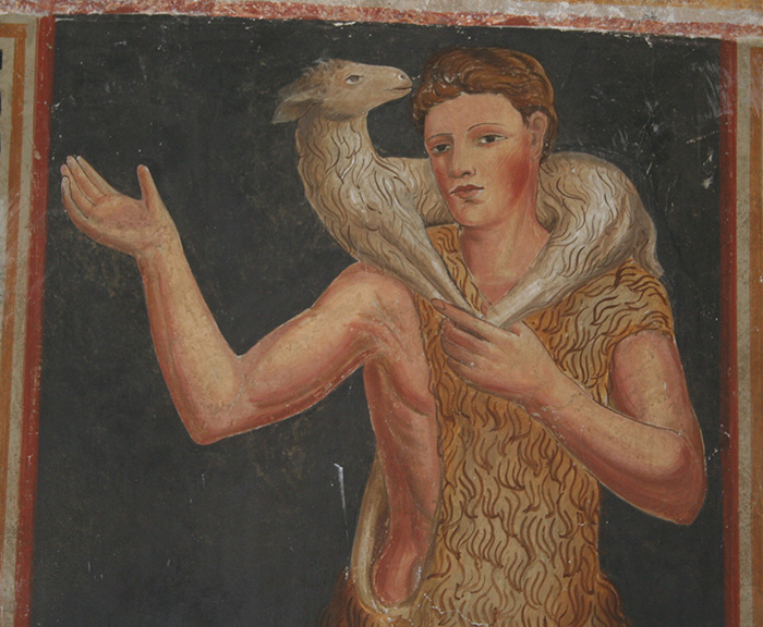 |
One of frescoes in the chapels on the left
|
| |
|
 |
|
 |
| |
|
San Sebastiano on the right wall |
|
One of the frescoes in the chapels on the left
|
Events
The Capalbio Cinema International Short Film Festival, which was founded by director Michelangelo Antonioni in 1994, takes place at the Blickle Kino twice in April. Capalbio Cinema promotes the international short production, mainly on works shot and shown on film.

To the east of Capalbio lies the hamlet of Pescia Fiorentina. Once the site of a customs house between the Grand Duchy and the Church State, iron-works were established here in the 15th century.
Situated in the tiny Italian village of Pescia Fiorentina, is the Garden of the Tarot Cards, an original creation by the French artist Niki De Saint Phalle. The garden is half a dozen miles from the beach resort of Capalbio.
Il Giardino dei Tarocchi
|
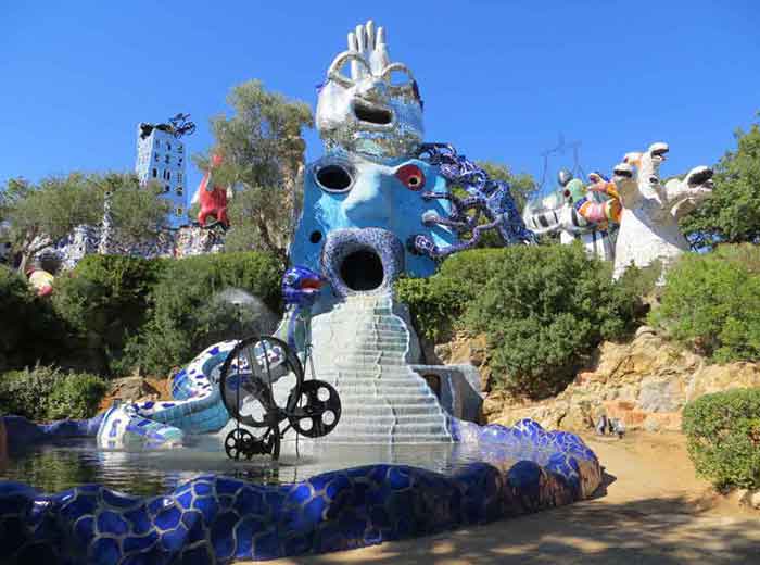 |
Giardino dei Tarocchi
|
Il Giardino dei Tarocchi (The Tarot Garden) is surrounded by Mediterranean macchia, a timeless fascinating area. Amidst hilly verdant woods stand the large polychrome sculptures covered in glass, ceramic and mirrors which were inspired by the 22 most important mysteries of the tarot deck. The sculptures are a tribute to Antonio Gaudi and also recall the grotesque garden sculptures at Bomarzo, near Viterbo. The garden is the main and most engaging work by Niki de Saint Phalle.
Based on the images pictured on Tarot cards, Niki de Saint Phalle has created a fantasy world of 20 sculptures. As unpredictable as the Tarot deck used in fortune telling is the serendipitous galaxy of fanciful sculptures, some of which are building-sized. Many of the works are made of iron mesh, sprayed with cement and embellished with a mosaic of Murano glass, mirrors and ceramic tiles, and such symbols as serpents, eggs and hearts abound.
The construction of the garden began in 1979 in collaboration with Niki de Saint Phalle's husband Jean Tinguely.
A few of the noteworthy Saint Phalle sculptures are "The Magician," crowned with a huge mirror-tiled hand; the Empress (or Sphinx), which Niki de Saint Phalle has used as her home and studio, and Falling Tower, which suggests the chaos at the Tower of Babel, with every window a different size and with the roof and top floor teetering. Still to be completed are two sculptures.
To get to Pescia Fiorentina, which is a mile from the main road, Via Aurelia, follow a gravel road and signs for the Villa Caracciolo or those indicating sculture. The garden is open in July and August, from 4 to 8 P.M. and from Monday to Saturday. Admission is free.
Il Giardino dei Tarocchi | Niki de Saint Phalle
Address | Garavicchio - Capalbio (GR)
Opening hours | From 1st April 2006 to 15th October 2006: 14.30 – 19.30
|
Niki de Saint Phalle, Giardino dei Tarocchi
|
 |
|
 |
|
 |
| Niki de Saint Phalle by Lothar Wolleh |
|
Niki de saint-phalle, Motto dell'artista, su una piastrella de L'Appeso
|
|
Niki de Saint-Phalle, Giardino dei Tarocchi |
Ansedonia
|
Ansedonia, high on a rock, with many narrow and charmimng streets right above the sea, is a nice and suggestive town to visit. Some great places to see are: the so called spacco della Regina, among the rocks, the Roman city of Cosa, founded in 273 a.C. Cosa offers to its visitors many spectacular things to see, such as the Great Capitolum ruins, a three cells temple, the Forum area, for commercial and political purposes, the Basilique, the Comitium, another Temple. Moreover: the ancient San Pancrazio and San Biagio rooks, the Etruscan Tagliata, the great Roman Villa Marittima, the Cosano harbour, built between the Second and the First Century B.C. This archaeological area is still recovering many ruins.
|
Cosa
|
In Ansedonia you can visit the remains of the “city of Cosa” and its museum on the promontory of the Etruscan Tagliata “Spacco della Regina” with a marvellous view on the Argentario.
Cosa is situated on top of the Ansedonia hill, and has a roman forum, the antique dwellings of peasants, the acropolis with the remains of monumental temples, and one of the most beautiful panoramic view of the Argentario and the laguna of Orbetello.
The most impressive feature of Cosa is the 1.5 km long circuit of walls, reinforced by 18 towers, some of which are still standing, including the Porta Romana, through which the site is entered, the remains of the forum with a basilica, two temples and the walled acropolis with the capitol. There is also a small museum.
At the foot of the hill, a port was built and equipped with impressive infrastructures, in part still visible.
From the site a road runs down past the massive Torre San Biagio, built by the Saracens, to the so-called Tagliata Etrusca (Etruscan cut), a drainage channel cut through the tufa. This expedient consists of an artificial canal dug into the rock, partially in tunnels and partially open-air, for a length of more than 80 metres. The interior of the Tagliata can be visited today, crossing over a little bridge over the modern canal.
The name is misleading, for the channel was cut by the Romans (though the Romans did in fact gain their knowledge of hydraulic engineering from the Etruscans). The channel was designed not only to prevent the silting-up of the ancient harbor but also to drain the low-lying hinterland and preserve the little Lago di Burano, to the southeast, from degenerating into marshland. Today, fully 2000 years after its construction, the Tagliata Etrusca still fulfillls its function. On the water's edge is a large cavity in the rock known as the Spacco of Bagno della Regina (Queen's Bath). Popularly supposed to be a rock sanctuary, it is in fact part of the drainage works.
Wikipedia Cosa (eng)
Scientific Itineraries in Tuscany | Tagliata of Ansedonia
|
|
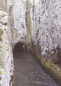 Spacco of Bagno della Regina (Queen's Bath)
 |
 |
Cosa, situated on top of the Ansedonia hill, view from Orbetello
|
Lake of Burano Nature Preserve
|
|
|
|
| |
|
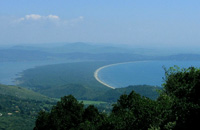
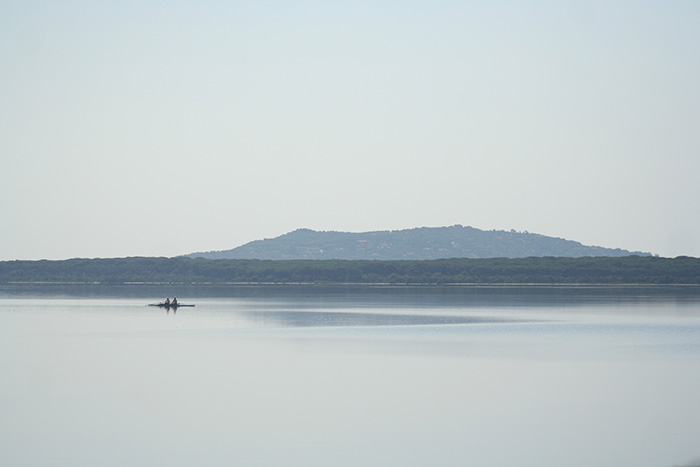
The road continuing along the coast past Capalbio Scalo reaches the Lake of Burano, a remnant of the vast swamp that once covered the entire plain. The swamp dried up because of the effects of the marine sediments and reclamation projects.
The lake is home to the Lake of Burano Nature Preserve, created in 1967 and the oldest of the World Wildlife Fund's protected areas.
|
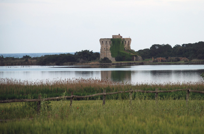 |
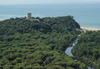
La Torre di Buranaccio, Lago di Burano, Capalbio.
The Buranaccio Tower stands at the centre of the narrow sandy isthmus separating lake from sea
. |
The Buranaccio Tower stands at the centre of the narrow sandy isthmus separating lake from sea.
The tower was built by the Spaniards in the 16th century to guard the southeastem border of the Garrison State. Now private property, the tower is a low, square construction with an access ramp crowned by brackets and crenellation and is simitar in type to the Rocca of Porto Santo Stefano.
|
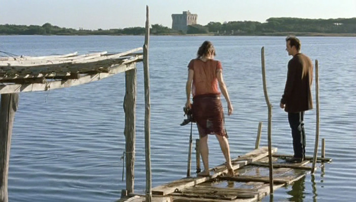 |
Regina Nemni and Christopher Buchholz in Michelangelo Antonion's Il filo pericoloso delle cose
|
Film in Tuscany
Eros is a 2004 Italian drama film consisting of three short segments directed by Wong Kar-wai, Steven Soderbergh, and Michelangelo Antonioni. Each of the three segments addresses the themes of love and sex. Antonioni's The Dangerous Thread of Things was filmed on Capalbio beach and in Lago di Burano.
|
Watch the trailer of 'Il filo pericoloso delle cose'
|
|
| |
 |
Walking in Tuscany | Lago di Burano and Tombola di Feniglia, itineraries between sea and mountains
|
| |
Extending parallel to the coast, Lake Burano and the immediately surrounding district make up one of the most important wetland habitats in Italy in terms of the integrity of the environment and accommodation and teaching facilities.
[read more]
|
|
|
Walking in Tuscany | Itinerary in the Naturalistic Archeological Park of Vulci
|
|
|
| |
The itinerary combines stunning gorge scenery and fascinating archaeological discoveries. A Roman road winds through the ruined temples and market place of Etruscan Vulci. Then on through holm oaks and wild olive trees to the stunning waterfall at Lake Pellicone, look out for kingfisher at the water's edge.
[read more] |
|
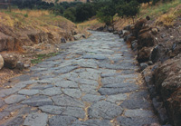 Vulci, strada Etrusca
 |
 |
|
|
Cicloturismo nella Maremma in Toscana
|
|
|
| |
La costa, il lago di Burano e la Pedemontana
Ansedonia Stazione - Oasi LAGO di Burano - Chiarone Scalo - Garavicchio (Giardino dei Tarocchi) - Borgo Carige - Ansedonia Stazione
Il giro della laguna di Levante
Orbetello - Località Terrarossa - Tombolo della Feniglia - Ansedonia (Cosa ) - Via di Camerette - Orbetello Scalo - Orbetello
Giro del Monte Argentario
Orbetello - Porto Ercole - Punta Avvoltore - Strada Panoramica - Porto Santo Stefano - Orbetello
|
|
|
|
 |
| Wine in Tuscany | Capalbio DOC |
| |
|
|
|
| |
D.O.C. Capalbio is famous for the white wine Capalbio and for the Vinsanto fortified wine.
The vineyards of the Capalbio DOC wine stretch across the hills and foothills south of the province of Grosseto and the region of Tuscany. The production area of Capalbio DOC includes parts of the territories of Magliano in Toscana, Orbetello, Manciano and Capalbio.
Capalbio DOC includes Capalbio Rosso (min 50% Sangiovese with other red non-aromatic varieties), Capalbio Sangiovese (85-100% Sangiovese with up to 15% of authorized non-aromatic red grapes), Capalbio Rosato (the same as the Rosso), Capalbio Cabernet Sauvignon (85-100% Cabernet Sauvignon), Capalbio Bianco (a blend of Trebbiano Toscano with other permitted non-aromatic white grapes), and Capalbio Vermentino (85-100% Vermentino).
|
|
|
| |
Vin Santo
|
|
|
| |
Vin Santo (holy wine) is a traditional Tuscan wine is made from Trebbiano and Malvasia grapes, and is typically very sweet.
Made from half-dried grapes aged in small wooden barrels, Vin Santo is an exquisite dessert wine.
Capalbio Vin Santo is best matched with crostate and cantucci biscuits.
|
|
|
|
Organic Wine
Il Cerchio is located in a reasonably flat area between the village of Capalbio and the sea. The choice of organic methods of production was made from the very birth of the enterprise in 1988.
Map Strada dei Vini Colli di Maremma
Wines in Tuscany | Organic winegrowing in southern Tuscany
Villa Pinciana
|
|
|
| |
Villa Pinciana is part of a 54 hectares wine estate in Maremma Tuscany, within walking distance to Capalbio medieval town. Wines include Toscana IGT Tilaria, Terraria, Airali and Viognier.
How to get there
Take the Capalbio exit on the Aurelia when coming from Rome or Grosseto. From the town, take the SP 63 towards Marsiliana, after 1,5km you will find Villa Pinciana Road on your left.
Villa Pinciana
Strada Villa Pinciana, 2a
58011, Capalbio (GR)
|
|
|
| |
| |
|
|
|
|
Enlarge map
|
Frazioni
Borgo Carige, borgo rurale situato a sud di Capalbio, nato con la riforma agraria dell'Ente Maremma e oggi importante frazione del comune.
Capalbio Scalo, detto anche Capalbio Stazione, perché situato lungo la ferrovia Tirrenica, è il centro logistico del territorio comunale, situato nelle immediate vicinanze del lago di Burano e della strada statale Aurelia.
Chiarone, frazione situata nelle vicinanze del fiume Chiarone, all'estremità sud del territorio comunale e regionale, al confine con il Lazio. La frazione si divide in due località distanti tra loro due chilometri e unite da un'unica strada. Il primo agglomerato si formò nel cinquecento intorno al palazzo del Chiarone, sulla via Aurelia: con l'istituzione del vicino confine tra il Granducato di Toscana e lo Stato della Chiesa, la proprietà del terreno passò allo stato pontificio, pur trovandosi in territorio granducale, che lo adibì a dogana. Il secondo agglomerato venne denominato Chiarone Stazione perché situato lungo la ferrovia Tirrenica. Nel censimento del 2001 la frazione contava poco più di 20 abitanti.
Giardino, piccola frazione che si è andata a formare nell'estremità nord-ovest del territorio comunale, al centro della cosiddetta Valle d'Oro, a ovest del centro di Capalbio, ricca di ritrovamenti di epoca romana. Nel 1945 è stata istituita la parrocchia autonoma, che estende la sua giurisdizione anche nei territori di Ansedonia e della Torba.
Pescia Fiorentina, piccolo agglomerato rurale posto all'estremità sud-est del territorio comunale, al confine con la regione Lazio, non molto distante dalla omonima Pescia Romana (VT). Importante centro siderurgico nel Quattrocento e nel Cinquecento, vi si trova nelle vicinanze il Giardino dei Tarocchi di Niki de Saint Phalle.
Selva Nera, piccola località andatasi a formare sul confine con la regione Lazio che ha dovuto il suo sviluppo alla costruzione della Torre di Selva Nera, una torre di avvistamento costruita dai Medici tra la fine del Cinquecento e gli inizi del Seicento dinanzi all'estremo lembo costiero meridionale del territorio del Granducato di Toscana, in un'area confinante a ovest con lo Stato dei Presidii e a est con lo Stato della Chiesa. La torre svolgeva principalmente funzioni di avvistamento, per evitare che eventuali incursioni dal mare potessero mettere a rischio il vicino centro di Capalbio situato sulle prime propaggini collinari dell'entroterra. Con la costruzione di case e abitazioni, la torre è stata modificata nel corso dei secoli e adesso ha assunto l'aspetto di un comune edificio. Nel censimento del 2001 la frazione contava 21 abitanti.
La Torba, piccola frazione situata nelle vicinanze del Mar Tirreno lungo la Via Aurelia, pochi chilometri distante da Ansedonia e conosciuta per le sue spiagge ferrifere.
Da ricordare le località di Ansedonia Sud, Carige Alta, Garavicchio, Nunziatella, Torre Palazzi e Vallerana.
Domenico Tiburzi
|
During the Middle Ages the zone went under the control of the Aldobrandeschi family and later under the control of the Orsini. In 1416 Capalbio went under the control of the Sienese enjoying a period of a renewed and florid commerce. In 1532 Charles V’s troops occupied the town and it was liberated thanks to the French troops. When it permanently fell under Siena, Florence took control of the area under the rule of Cosimo de’Medici starting a gradual decline of the town. In this period, Capalbio was practically the last stronghold facing the Spanish garrisons, therefore isolated, and malaria quickly took over the Maremma plains.
Under the Grand Duchy of Tuscany of the Lorena, Capalbio lost all of its administrative poker and was encompassed first by Manciano and later by Orbetello. In the second half of the 1800’s, during an intense period of banditry, Capalbio became a shelter for outlaws and her in 1896, died the most famous bandit of the time – Domenico Tiburzi.
Also a poem – by an anonymous – celebrates the epic deeds of Domenico Tiburzi, controversial figure of the Maremma banditry world of the 19th century.
After more than a century, still today, there are those who condemn him without appeal as a cruel bandit who had been guilty of about 20 homicides and those who mythicise him as defender of the destitute, making him a romantic hero who stole the rich to give the poor.
Anyhow, the adventurous life of Tiburzi ended the night of the 23rd October 1896 when the Carabinieri set a trap for him at Forane, in the country house of the Franci family (to whom he had asked hospitality) where he sheltered with his inseparable companion Fioravanti. We know for sure from the chronicles Tiburzi was hit on a leg during a shooting; it’s not clear what happened after. According to another version the “King of Lamone” killed himself, preferring to die rather than fall into the law clutches.
However, if his last minutes are shrouded in mystery, even more mysterious, almost legendary, is the matter related to his burial. Over hundred years of researches, investigations and inquiries have not been enough to throw some daylight on what really happened that fall night.
According to the most reliable, but also the most fanciful, version, the priest of Capalbio refused to officiate a standard funeral service and burial in the graveyard for that man considered a criminal, a sinner, a godless person.
However the priest had to reckon with the will of the whole community which, on the contrary, demanded a honoured burial in hallowed ground for the “paladin of the rights of the weak”: the body of Domenico Tiburzi could be buried in hollowed ground but … just for a half!
The other half should be outside the cemetery! And so it was. The grave was dug at the gate of the cemetery with the legs inside and the head, the chest – that is the soul – outside. But neither cross nor tombstone, complete oblivion.
Today everything is shrouded in mystery, because, in the meantime, the cemetery of Capalbio has become bigger, and we don’t know where the old gate was, the only reference point of his burial.
And so Domenico Tiburzi, the “King of bandits”, the mythic bandit from Maremma, lays shrouded in his legendary halo.
Luigi Ugolini, Domenico Tiburzi, Old Maremma (Domenico Tiburzi, vecchia maremma), 1933 (Vallecchi)
|
|
Domenico Tiburzi: l'unica fotografia scattata dopo la sua uccisione. Fonte foto: archivio.gonews.it |
Cicloturismo in Maremma | La costa, il Lago di Burano e la Pedemontana | Verso il Giardino dei Tarocchi
|
|
|
| |
|
|
|
|
|
|
Tombola di Feniglia, view from
Monte Argentario
Between Ansedonia and Porto Ercole lies the gorgeous sandy beach stretching from Feniglia for 6 km. You can only reach this part by foot or bicycle as this park is unter nature protection.
|
|
The Parco Naturale della Maremma
The most famous part of the Maremma is the Parco Naturale della Maremma, otherwise known as the Parco dell'Uccellina
|
|
|
The Maremma is outstanding for its many protected natural areas that offer the chance to appreciate its wide variety of animals, insects and birds, trees, shrubs and flowers and to enjoy its special light and scenic beauty.The Nature Reserves aren't separate from the rest of the territory, but are symbolic of an integral whole. The Maremma affirms a way of life in harmony with nature and the rhythm of the seasons.
The Parco Naturale della Maremma encompasses the Monti dell'Uccellina, running parallel to the coastline from Principina a Mare to Talamone and was one of the first protected areas instituted in Italy. The Natural Park of Maremma winds along an interesting mosaic of ecosystems for 25 km: from Principina a Mare, the river Ombrone and the mountains of the Uccellina, covered with maquis, in the north to a marsh area and sandy or rocky coast in the south to Talamone. The Natural Park of Maremma thrive an amazing amount of wild animals and plants interesting, reeling from a typical habitat of the Mediterranean coast: wooded hills, olive groves, pastures, pine forests, dunes, estuaries and mudflats and represents an ideal natural habitat for horse and bovines. In the environments of the pastures moreover they live stably hares, foxes, porcupines, wild boars.
Many itineraries are proposed, you can plan on your own or can be toured with a guide after booking. In addition the park offers tours by horse, chariot, canoe and bicycle.
Orbetello
The town of Orbetello lies on a narrow tongue of land jutting out into the eastern and western lagoons and has been joined to the Monte Argentario promontory since 1841 by an artificial dyke. The two lagoons are closed by two strips of land, the tombolos of the Feniglia and the Giannella, offering several miles of beaches. Thanks to its unusual setting, the town appears from above like a ship anchored in the still waters of the lagoon, with the artificial dyke forming a gangplank linking it to the Argentario peninsula. The origins of the town and of its name, Orbetello, are unclear: Orvelus, Urva Tellus or Urbis Tellus - the circular town, the town of herbs or the town of towns? Perhaps if it had not been plundered in 1455 and the town’s archives destroyed we would know more.
From 1557 to 1801 was the capital of the Stato dei Presidi, until was annexed to Grand Duchy of Tuscany from Napoleon. At the beginning of the last century the town’s economy was still largely based on farming and fishing in the lagoon. The development of industry brought several factories, the mines, the hydro port and the fish processing plant. These industries transformed Orbetello into a busy and prosperous town that was dubbed “Little Venice” or “Little Paris”. It’s name is also linked to an important chapter in the history of Italian aviation. Four transatlantic hydroplane flights took off from the lagoon: from the first Atlantic crossing in 1928 to the last and most famous - Orbetello - Chicago - New York - Rome - in 1933.
Ansedonia and the ancient Roman town “Cosa”
At the mainland end of the Feniglia tombolo Ansedonia rises above the sandy shore, a green contrast to the darker Mediterranean maquis of the Feniglia.
On top of the hill are the evocative ruins of Archaeological Area of Cosa, Roman colony founded in 273 BC, perhaps on land confiscated from the Etruscans. Its strategic position allowed to control the sea and land flow. Cosa seems to have prospered until it was sacked in the 60s BC, perhaps by pirates. Today is an important archaeological site in Maremma. The coastline is steep and rocky: “la Tagliata” is a canal cut in the rock in Roman times, still visible; and “lo Spacco della Regina” is a natural cleft in the rock on which the sunlight produces fantastic light and shade effects.
Walking in Tuscany | Lago di Burano and Tombola di Feniglia | Walking in Tuscany, itineraries between sea and mountains
Monte Argentario was probably an island that gradually became joined to the main coast as the accumulated detritus deposited by rivers and the sea formed the two tombolos of the Feniglia and the Giannella. Archaeological finds from the Grotta degli Stretti and Cala dei Santi show that the area was settled by humans in very early times. At least 10 caves are known to have been lived in, one of which, the Grand Duke’s Cave (la Grotta del Granduca, named after Leopold of Lorraine who sponsored its excavation), is almost a mile in length and even has a small lake about 50 yards from the entrance. The peninsula was considered a safe haven by seamen on account of its geographical position in the centre of the Tyrrhenian Sea: it was also strategically placed and became the site of numerous look-out towers to give warning of impending danger from the sea. The threat of invasion was indeed constant and during one memorable incursion in 1544 the pirate Khair ad Din, known as Redbeard, plundered the village of Porto Ercole.
The earliest defence works date from the Bronze Age, but it was only in the XV century A.D. that the Senese Republic started to build a proper defence system encompassing the whole promontory. However, it was the Spanish who, in only a few years, transformed Monte Argentario with a powerful complex of military forts, far greater in number and effectiveness than any others in Tuscany. Thus was the Stato dei Presidi (literally, the Garrison State) founded; it included Orbetello, Porto Ercole, Porto Santo Stefano and Talamone. To these in 1602 was added the stronghold of Porto Longone on the island of Elba. The mountainous peninsula rises to a height of 635 m, and has a rocky coastline. The vegetation is mostly thick Mediterranean maquis alternating with olive groves, vineyards and fruit orchards: it is famous for the dwarf palm, which here grows wild. The rare Ansonico and Riminese varieties of grape are grown in terraced vineyards on the hillsides. Today tourism has replaced fishing as the principal economic activity of the area.
Porto Ercole
The picturesque town of Porto Ercole with its thriving tourist harbour lies on the eastern coast of Monte Argentario and is dominated by the massive Spanish forts. The nearby marina of Cala Galera attracts large numbers of yachts and pleasure boats with its excellent facilities. The origins and early history of Porto Ercole are hazy, but the name Ercole was probably used by the Etruscans. The recent discovery near Cala Galera of an Etruscan necropolis situated in the thirteenth sector of the Etruscan zodiac, corresponding to the constellation of Hercules, would appear to confirm this.
In the early Middle Ages it belonged to Three Fountains Abbey, together with the rest of the promontory. In the thirteenth century it became the property first of the Aldobrandeschi and then of the Orsini families, before falling to the Senese Republic in 1415. Under the Stato dei Presidi, in 1557, it formed the mainstay of the peninsula’s defence system with its imposing military forts. In 1610 the painter Michelangelo Merisi, better known as Caravaggio, died alone as a fugitive on a nearby beach, probably of malaria.
Porto Santo Stefano
Situated on the north coast of Monte Argentario, Porto Santo Stefano is the largest town on the peninsula and its administrative centre, as well as a renowned tourist resort. The old and new harbours together are a hub for both business and tourist activities, including a fishing fleet, sailing and ferries linking the port with the islands of Giglio and Giannutri. There are also several small boatyards and shipwrights. The town first developed around the fort after the foundation of the Stato dei Presidi, especially under the governorship of Gilles Nunez Orejon. From the XVIII century onwards families of fishermen from Liguria and Naples started to settle in the town and their descendants still account for a sizeable portion of the population.
The Garden of the Tarots | Capalbio
The Tarot Garden (Il Giardino dei Tarocchi) is an exploration of the human condition whose medium is mosaic on a monumental scale. These almost impossibly brightly coloured combinations of buildings and sculpture reflect the metaphysical qualities represented by the 22 main tarot cards (the major arcane). They’re not concerned with the fortune-telling uses of the cards, rather the elements of life’s experience, personality and self-knowledge they refer to.
Niki de Saint Phalle worked on the garden from 1979 and it was officially opened to the public in May 1998. The Garden of the Tarots seems a museum in the open air completely integrated in the hills of Maremma. Owing to the fragility of sculptures, the magic atmosphere of the garden, the tours are permitted from April to October, in the afternoon. According to Niki de Saint Phalle‘s wish, the itineraries are not pre-established for giving visitors a freedom of action.
|
“A me dà più soddisfazione fare qualcosa di bello per gli altri e per me che avere, AVERE, AVERE… sempre di più, di più, DI PIÙ…”
This is the motto of the artist Niki de Saint Phalle, at the entrance of the park designed by her, the Giardino dei Tarocchi.
|
 |
Photo by Sailko
|
Vulci
The Etruscan city of Vulci (VelX- in Etruscan) lies on the border between Lazio and Tuscany, about fifty miles north-west of Rome. It stood close to the sea on the right bank of the river Fiora, on a plateau of volcanic origin, in an area which is today uninhabited. The National Museum is housed in the Castle of La Badia, where finds from the excavations in the city and necropolis are on display.
Vulci was an important town of the ancient Etruscans, the ruins of which are about 10 miles (16 km) from the sea between the villages of Canino and Montalto di Castro, inViterbo province, Italy. The site, excavated in 1956, has extensive cemeteries and a large network of streets and walls. Vulci grew out of a number of Villanovan villages in the 8th century bc and flourished chiefly in the 6th–4th century bc, largely as a result of trade, the extraction of minerals from nearby Monte Amiata, and the manufacture of bronze jugs and tripods, etc.
www.vulci.it
Walking in Tuscany | The Naturalistic Archeological Park of Vulci
The Maremma seashore, overlooking the Tirrenian Sea, features some of the most beautiful sand beaches of Tuscany. Some of the most beautiful beaches in Tuscany (Marina di Alberese, Principa a Mare, Cala Violina, Castiglione della Pescaia), are within easy reach of Podere Santa Pia. The Maremma extends into the northern part of Lazio in the province of Viterbo. The sub-region is called the Maremma Laziale, and it has a couple of beaches worth checking out.
Torba extends east of the promontory of Ansedonia. The beach is characterized by sand ranging in color from dark gray to black. Proceeding toward the Lake of Burano and the mouth of Chiarone, the shoreline tends to soften the color and come forward tone between dark gray and gold. The entire stretch of the coastal zone is presented with wild dune vegetation, and Mediterranean retrodunal (macchia).
Chiarone Scalo beach can be reached going from the promontory of the Argentario toward Capalbio Scalo. It has an almost black sand and clear, transparent water. Thick wild scrub and broad dunes encircled the beach.
Capalbio Beaches are Chiarone, Macchiatonda and Capalbio Scalo. The beaches have an almost black sand and clear, transparent water. Thick wild scrub and broad dunes encircled the beach.
The Marina di Montalto near the medieval town of Montalto di Castro is a modern tourist resort with hotels, campgrounds, and plenty of beach chairs to rent for the day. Further south, Tarquinia, which is known for its Archeological Museum of local Etruscan finds, also has a seaside area with similar facilities to Marina di Montalto.

|
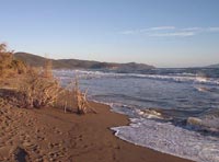
The coast of Capalbio extends about 12 km from the border of Ansedonia all the way to the end of Tuscany. A nudist beach can be found at Macchiatonda beach. At the beach house you have to walk for 20 minutes south.
Nudist beaches in Tuscany | La costa, le spiagge e il mare della Toscana naturista
The most beautiful beaches of Tuscany | From Principina a Mare to Ansedonia
|
|
 |
| |
|
|
|
|
 |
|
 |
|
|
Torba
|
|
Il forte di Macchiatonda |
|
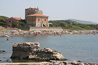
Spiaggia e Torre della Tagliata
|
| |
|
|
|
|
| |
|
|
|
| |
|
|
|
| |
|
|
|
| |
|
|
|
| |
|
|
|
| |
|
|
|