| |
|
| |
|
|
|
|
|
|
| |
 |
 |
| N E D |
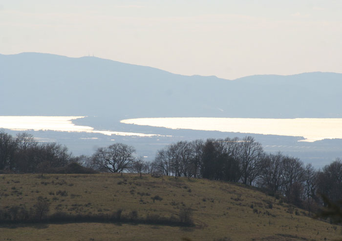
Monte Argentario and Tombolo di Giannella, view from Scansano
|
|
 |
 |
| |
|
|
|
| |
|
|
|
|
| |
|
Monte Argentario is one of the most famous spots in the Maremma and Tuscany. The promontory, which was originally an island, is characterized by a high, rocky coastline covered by a thick Mediterranean thatch, interrupted by olive groves and vineyards. It is now connected to the land by the Feniglia and Giannella sand bars, two strips of uninterrupted sandy beach and thick maritime pine. The sandy isthmuses are separated by the Laguna di Orbetello, an area protected by the WWF because it sits on one of the most important migratory routes and is one of the principal wintering sites for birds that nest in Europe. The serene tranquility of this lagoon contrasts with the high jagged Monte Argentario coast that hides small inlets in rocks that are inaccessible from the land.
Monte Telégrafo, the highest point on Monte Argentario (635m/2,083ft), lies in the southeast of the peninsula, 17km/11 mi from Porto Santo Stéfano by a road which branches of SS 440 (the Orbetello road), on the south. On this road, commandingly situated at a height of 275m/900ft, is the Convento dei Padri Passionisti. From here there are magnificent views, extending seaward in good weather, as far as the French island of Corsica and inland as far as Monte Amiata.
Dominated by the 17th-century square-plan fortress, built by the Spanish to defend the port, Porto Santo Stefano originated in the 15th century as a fishing village. Fishing continued to be the almost exclusive activity of its inhabitants until not many decades ago, when the town became a famous seaside resort, appealing to a wide range of tourists, the fashionable élite as well as ordinary holidaymakers, some staying for a while, others passing through whilst waiting for a boat to the islands in the Tuscan archipelago. In the summer period the fortress is the venue for a wealth of cultural activities and exhibitions.
Porto Santo Stefano is the largest town on Mount Argentario, and connections leave from here for the islands of Giglio and Giannutri. Porto Santo Stefano is a famous resort with two ports, Porto Nuovo a, nd Porto Vecchio. Every 15 August, they play the Palio Marinaro, the historic rowboat race on the southern Tuscan coast. The race is preceded by a historical procession in Spanish costumes.
|
|
|
|
| |
|
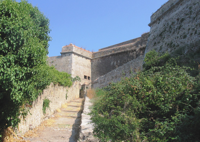 |
Porto Ercole - Forte Filippo
|
Porto Ercole is located on the eastern coast of the Argentario. It is a charming seaside village that overlooks a bay protected by a small promontory. It is a maze of lanes and stairs that descend tortuously from the fortress to the port. The main sights to visit in Porto Ercole include the 16th century Palazzo Consani, the old parish church of San Erasmo (where Caravaggio was buried in 1610) and the fortifications that date from the period of Spanish domination in the 16th century: Forte San Filippo, Forte Santa Caterina, Forte Stella and La Rocca.
Porto Ercole was the Roman Portus Herculis of antiquity, but finds from a a pre-Roman settlement testify to even remoter origins. The town is set in a bay and climbs up a little headland on the eastern coast: though it is a centre for fishing and a bathing resort with every amenity it has retained its ancient appearance despite modern tourist installations. Dominating the whole are the colossal fortifications, masterpieces of XVI century military architecture, that Philip II of Spain had built to defend the Stato dei Presidi. The harbour and sea are dominated on every side from the heights of the fort La Rocca and this is faced by Fort Filippo and Fort Santa Caterina while Fort Stella rises from a distant hill. The old part of Porto Ercole is reached through an ogival gateway in the Sienese style, cut into the encircling town walls that in earlier times linked the Rocca fort with that of S.Barbara, but, today, these have all but disappeared. The original nucleus, formed of a maze of narrow streets surmounted by arches, dark alleys and steep flights of steps cut into the rock, has an atmosphere that never fails to evoke a response. Looking out over the little square of Santa Barbara is the Palazzo del Governatore which was built at the beginning of the XVI century by the rich Sienese banker Agostino Ghigi. The mansion was plundered and destroyed by the Saracen pirate Cair Heddin Barbarossa, but rebuilt under Spanish domination and was used as the residence of the governor of the fortress. During the Second World War it was seriously damaged and has since been restored. Of the original building there remain only the porches and the facade. At the end of the same square stands the bastion of Santa Barbara, an ancient Byzantine light-house that the Sienese transformed into a small fort. The most ancient church in the township, standing almost directly below the Rocca fort, the old parish church of San Erasmo (where Caravaggio was buried in 1610). Botany lovers may, with the permission of the owners, visit the luxuriant park of Villa Corsini, also know as Casa Bianca, which stands between the lower town and the old walled town. A mile to the north of the Porto Ercole harbour is Marina di Cala Galera. Here, boats of considerable tonnage can put in at one of the best organized tourist landing places on the Mediterranean.
The Convent of the Passionists can be reached through a deviation to the right of the road from Porto Santo Stefano to Porto Ercole, through a route cut between two thick walls of Mediterranean bush. The convent of the Passionists, where almost three hundred years ago San Paolo della Croce started his mission, is surrounded by the green secular plants and by a deeply spiritual atmosphere. As one ascends, the entire lagoon system unfolds, with Orbetello in the middle.
The complex, inaugurated in 1737 and later expanded, consists of a convent area used by the monks, the sacristy and the Church of the Presentation. The church has a Neoclassical facade. The interior seems almost circular, is decorated with Baroque stuccoes and has a few important works of art. On the altar of the transept to the left is the painting of San Michele Arcangelo (St. Michael Archangel), protector of the Passionists. In the chapel to the right of the entry, is a painting that is meaningful in the history of the convent: La Madonna col Bambino che consegna a san Paolo della Croce il progetto del convento (The Madonna with Child who Delivers the Convent Plan to St. Paul), painted in 1880 by Pietro Aldi of Manciano. The painting offers an interesting glimpse of Orbetello and the lagoon as seen from Mount Argentario.
Comune
|
Album Monte Argentario | Monte Argentario
|
|
|
 |
|
 |
|

|
Porto Santo Stefano
|
|
La Torre di Cala Grande occultata dalla vegetazione |
|
Orbetello - Vista dal convento dei frati passionisti
|
 |
|

|
|
 |
| Cala Grande dalla strada panoramica di Porto Santo Stefano
|
|
Porto Ercole - Vista fortezza dalla rocca [2] |
|
Porto Ercole - Harbour view from the "rocca"
|
 |
Beautiful panorama of Porto Santo Stefano from the street of the sun. In the background the Giannella tombolo
|
Photo galleries | Photo gallery Porto Santo Stefano | Galería Fotográfica de Porto Ercole |
|
|
| |
|
Ansedonia
Directly across the harbor from Porto Ercole lies Ansedonia, an almost sleepy little town with some of the best beach front in Tuscany. Rather than the rocks and pebbles that greet you on so many Italian beaches, Ansedonia offers soft, velvety sand.
Ansedonia flourished in the 60's, with well-known architects of the time designing villas for the rich and famous, mostly in the mass-media circuit. Now, it is seen more as a retro relic of the past society.
Above Ansedonia, in the archeological zone, lie the ruins of the Roman city of "Cosa". Below, on the slopes near the sea, lies the peaceful residential zone with numerous villas set in green vegetation offering direct contact with nature.
The ancient city of Cosa, situated on a small rocky promontory 114 meters above sea level, was in historic times connected to the primitive island of Argentario by a thin strip of land referred to as the Tombolo di Feniglia.
Its foundation dates back to 273 B.C. in which it became a Roman colony after the territory was conquered by the Consul Tiberius Coruncanio. The name Cosa itself derived from the ancient name "Cusi" or "Cusia", corresponding to a small Etruscan center established where Orbetello lies today.
It seems that Cosa was developed as a strategic point in the water in the middle of the Tyrrheanian Sea since battles with Carthage were anticipated, thus its location was not by chance.
The Romans, thanks to new military techniques acquired during the Samnite war and the campaigns of Pyrrhus, erected, also in Cosa, a mighty enclosed wall with three access ports to the city, which were constructed with enormous polygonal masses of limestone embedded between them; they also erected 17 square towers situated on the side facing the sea.
The Cosa Museum | Via delle Ginestre, Ansedonia | url (it)
The museum has been established by the American Academy in Rome in collaboration with the Archeological Office. It contains archeological documents from excavations in the area of the city and the ancient port of Cosa. It is divided in three sections: the Acropolis, the Casa Romana (Roman house) and the Forum.
|
The peninsula Monte Argentario is connected with the mainland by three dams which form two lagoons, the Laguna di Ponente on the west side and the Laguna di Levante on the east side of the middle dam. Orbetello is located on the middle dam between the two lagoons. Orbetello is joined to the Argentario promontory by two long, golden sand dunes, known as the Tomboli della Feniglia e della Giannella that offer the visitor kilometres of enchanting, unspoilt beaches ...
Spiaggia Feniglia. This impressive beach is 7 km long and it has fine white sand and is backed by a lush pine forest. It ends with the lagoon of Orbetello. It can easily be reached from Porto Ercole.
Riserva Naturale della Laguna di Orbetello (Grosseto) (it)
|
Monte Argentario | The Beaches
|
| |
 |
|
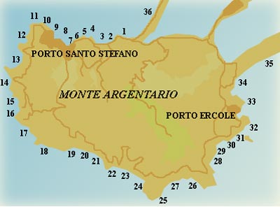
1 - Bagni di Domiziano
2 - La Soda
3 - Il Pozzarello
4 - La Bionda
5 - Punta Nera
6 - La Cantoniera
7 - Viareggio
8 - La Marinella
9 - Il Moletto
10 - La Caletta
11 - Il Siluripedio
12 - La Cacciarella 13 - Cala Grande
14 - Cala Moresca
15 - Cala del Gesso
16 - Cala del Bove
17 - Cala Piccola
18 - Capo d'Uomo
19 - L'Acqua Appesa
20 - Cala dell' Olio
21 - I Sassi Verdi
22 - Il Mar Morto
23 - Le Cannelle
24 - Il Purgatorio 25 - La Ciana
26 - Cala Piazzoni
27 - Le Ficaie
28 - L'Acqua Dolce
29 - Lo Sbarcatello
30 - La Spiaggia Lunga
31 - La Piletta
32 - Le Viste
33 - Le Pietrine
34 - Cala Galera
35 - La Feniglia
36 - La Giannella
|
| [read more | Tuscany Beaches in Maremma | From Principina a Mare to Ansedonia ] |
| |
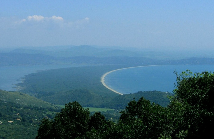 |
Tombolo di Feniglia, view from Monte Argentario |
| |
| Monte Argentario harbors the largest lagoon on the Tyrrhenian Sea as well as one of Italy's most important bird sanctuaries. About halfway between Rome and Florence, it makes a wonderful choice for birdwatchers. Take a guided tour of the WWF oases at Orbetello (open Sept. 1-April 30) and Burano (open Aug. 1-May 31) at 10 am and 2 pm on Thursdays and Sundays. Or you can go on your own: for Orbetello drive along the southern edge of the promontory (called Tombola di Feniglia); for Burano Lake take the northern shore road and then walk along the dunes. Or take the 4-hour walk around the coast from Feniglia to Burano. |
 |
|
|
| |
|
|
|
Capalbio Burano Lake, Lago di Burano
|
|
|
| |
Extending parallel to the coast, Lake Burano and the immediately surrounding district make up one of the most important wetland habitats in Italy in terms of the integrity of the environment and accommodation and teaching facilities. Lago di Burano is a typical Mediterranean coastal lagoon behind a line of sand dunes.
[read more]
|
|
|
| |
|
|
|
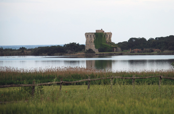 |
La Torre di Buranaccio, Lago di Burano, Capalbio
|
Tombola di Feniglia
|
|
|
| |
This protected area, the Tombola di Feniglia, is known for its long sandy beach lined with pines and protected lagoons for birds including herons, pink Flamingos and Corsican Seagulls.
[read more]
|
|
|
Enlarge map Monte Argentario |
The islands of the Tuscan archipelago
|
The islands of the Tuscan archipelago, a nature sea park, and an extraordinary place for the beauty of its depths and the cleanliness of the seawater. The Isles known as Giglio and Giannutri in particular are not to be missed.
[read more] |

Tuscany's Best-Kept Secret | Casa vacanza in Toscana Podere Santa Pia
Cicloturismo in Maremma | Giro del Monte Argentario | Orbetello - Porto Ercole - Punta Avvoltore - Strada Panoramica - Porto Santo Stefano - Orbetello
Percorsi mountain bike in Monte Argentario, Toscana (Italia)
| www.it.wikiloc.com
Maregiglio di Navigazione gives the following services
ll year round connections from Porto S.Stefano and/to Isola del Giglio for passengers and cars,
all year round connections from Porto S.Stefano and/to Isola di Giannutri, for passengers only.
During the summer season more services are offered as:
Daily excursions from Isola del Giglio to Isola di Giannutri;
short cruises from Isola del Giglio and Isola di Giannutri, departing from/to Porto S.Stefano;
tour around Isola del Giglio;
excursions to Isola di Motecristo (when allow by special authorizations)
www.maregiglio.it
Orari Navi/Ferry schedules/Fahrpläne: P.S.Stefano Giglio | www.isoladelgiglio.it
|
The Argentario Golf Club, located in a beautiful park of 70 hectares of olive groves and Mediterranean scrub, has a field of 18 championship holes. The area is particularly suitable for scuba diving enthusiasts frequenting the area for the great variety of different depths always rich in marine life.
Directions: Highway S.S.Aurelia (E80) exit Orbetello, follow to Monte Argentario, after passing the lake turn to P. Ercole, after 200meters turn right and follow signs to Argentario Golf Club (1km).
Argentario Golf Club | Località Terra Rossa, Via Acquedotto Leopoldi (58018), Porto Ercole GR
www.argentariogolfresortspa.it

|
|
|
| |
|
|
|
| |
|
|
|
| |
|
|
|
| |
|
|
|
| |
|
|
|
| |
|
|
|
