| |
|
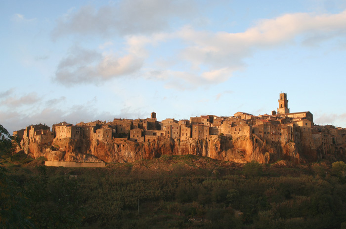
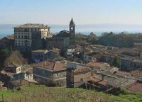
Pitigliano is one of the most scenographic villages of Tuscany. In particular arriving from the direction of Manciano, along road n° 74, in correspondence of the curve in front of the church of the Madonna delle Grazie is a scenographic vision of the town that raise majestic on a tufaceous rock, between the torrents Lente and Meleta. The houses of the town are built on the edge of the cliff forming with it a sole body and a whole somewhat picturesque. The cliff of Pitigliano is encircled from three sides from ravines that are full of caves dug in the tufaceous rock.
The Etruscan name is unknown, the present one derives from the gens Petilia, an important Roman family. The legend tells of two ancient Romans, Petilio and Celiano, who built this village, and by mixing their names you have the village name – Pitigliano.
The history of this part of the Maremma district could be described as a story of gradual marginalization with a consequent loss of autonomy. It almost seems as if, from a specific moment on, this geographic area became “destined to be a backdrop, with respect to others where the number and frequency of historically significant events aroused the interest of historiographers.” However, this loss of any major role allowed these places to maintain their original charm intact. Traveling through the Maremma is like going back in time and plunging into remote eras when ancient peoples decided to settle here and make the area flourish.
In the village we can recognize the various phases and eras of construction: the most irregular and oldest parts, the southern portion (Ghetto) and the end of the town at Capisotto are countered by the broader and more even structure of the recent portions. We can enter the hamlet via Piazza Petruccioli and the two old gates: Porta Capisotto and Porta Becherini.
|
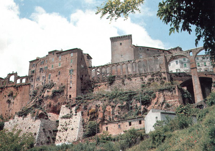
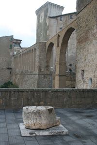
The historical center develops on three main streets (via Vignoli, via Roma and via Zuccarelli), nearly parallels, connected from a dense network of alleys. After to have crossed Garibaldi square where can be noticed the two stairs that carried to the bastions of the citadel, we flank the arched of the medicean aqueduct (built between 1636 and 1639 on 16th century plan (1545) of Antonio da Sangallo the Young, the ancient aqueduct of Pitigliano is formed from two large arches supported from an enormous pillar in blocks of tufa, going back to the medicean period, and from thirteen small arches realizes in the lorenese period. The scenographic construction raise to peak on the cliffs of tufa. The three fountains in the adjacent square of the Republic constitute the terminal of the aqueduct) and we entered in the large square of the Republic dominated from the Orsini Palace, also of aldobrandesca origin, it was restructured from the Orsini between the end of the 15th and the first half of 16th century. Currently it belongs to the Episcopal Curia and it's the seat of the Diocese of Pitigliano, Sovana and Orbetello. Palazzo Orsini accommodates two museums: the Archaeological Civic Museum and the Museum of Palazzo Orsini, united to the Library and the communal historical Archives and the diocesan Library and historical Archives.
Externally the Palace has a characteristic tower, the gateway is found to the term of a ramp, from which is approached the inner courtyard with a six arched porch, a hexagonal column well is found near the portal of access to the Palace, the Portal is carved in travertine and today is the entrance of the Museum.
Continuing in via Roma we arrive in the Piazza San Gregorio, and the 15 th century cathedral, with 18th century facade, and historic paintings by Pietro Aldi. Two paintings depict two important moments in the life of Ildebrando da Sovana, the future Saint Gregory VII, who is also present in the second chapel to the right (where a statue of him can be seen) and in the square named after him in front of the Duomo.
On the right side of the Cathedral is the Open Gallery of the Palace of the Community and in front is the Monument to the progeny Orsina.
Behind the Cathedral it's the characteristic Jewish Ghetto. Pitigliano was home to the Jews, possibly from the end of the fifteenth century, and became an important refuge centre for them in central Italy. In fact beginning from 14th century and then after the definitive expulsion of the Hebrew from the Papal State in 1569, numerous Hebrew families found shelter in Pitigliano, where a numerous Jewish community was forming. The Jewish Ghetto occupies the zone between the Cathedral and the Church of Santa Maria and is characterized from small and tightened streets, from the synagogue of 16th century, restored in 1995 after years of abandonment, from the Archives, the Jewish School and the furnace; outside from the city on the road towards Manciano is the small Hebrew cemetery.
Continuing from the Cathedral along via Gen. Orsini we reached the beautiful Church of Santa Maria, perhaps the most ancient of Pitigliano (12th century). It was restructured between the end of the 15th and the beginning of 16th century and shows a 16th century facade. The inside is a three aisles with frescoes of sienese school. Beyond the church is the Porta di Sovana from where we can admire another beautiful view on the houses of Pitigliano.
|
|
 Het Palazzo Orsini on the Piazza della Repubblica, and the aquaduct over the Via Cavour Het Palazzo Orsini on the Piazza della Repubblica, and the aquaduct over the Via Cavour

L'Acquedotto Mediceo di Pitigliano

Via Porta di Sovana, Pitigliano
|
 |
|
 |
|
 |
Pitigliano
|
|
La Porta di Sovana lungo le Mura di Pitigliano |
|
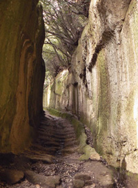
Vie Cave San Giuseppe, Pitigliano
|
The Church of Madonna delle Grazie is situated one kilometer from the center of Pitigliano, along the road that leads to Saturnia. Its panoramic location offers a beautiful view of the village. It was the church of a Franciscan convent that was established around 1400. The church has one nave with six altars. The original canvases have been lost and have been replaced by works by local artists. The church is currently in good condition since it was totally restored in 1962. The interior has some late Renaissance and Baroque decorations.
Weekly market on Wednesday.

Comune Pitigliano
Piazza Garibaldi, 37
Tel. 0564/616332 | Fax 0564/616738
www.comune.pitigliano.gr.it
Agenzia Per Il Turismo - Grosseto
51, PIAZZA G.GARIBALDI, 58017 Pitigliano (GR) |tel: 0564 617111
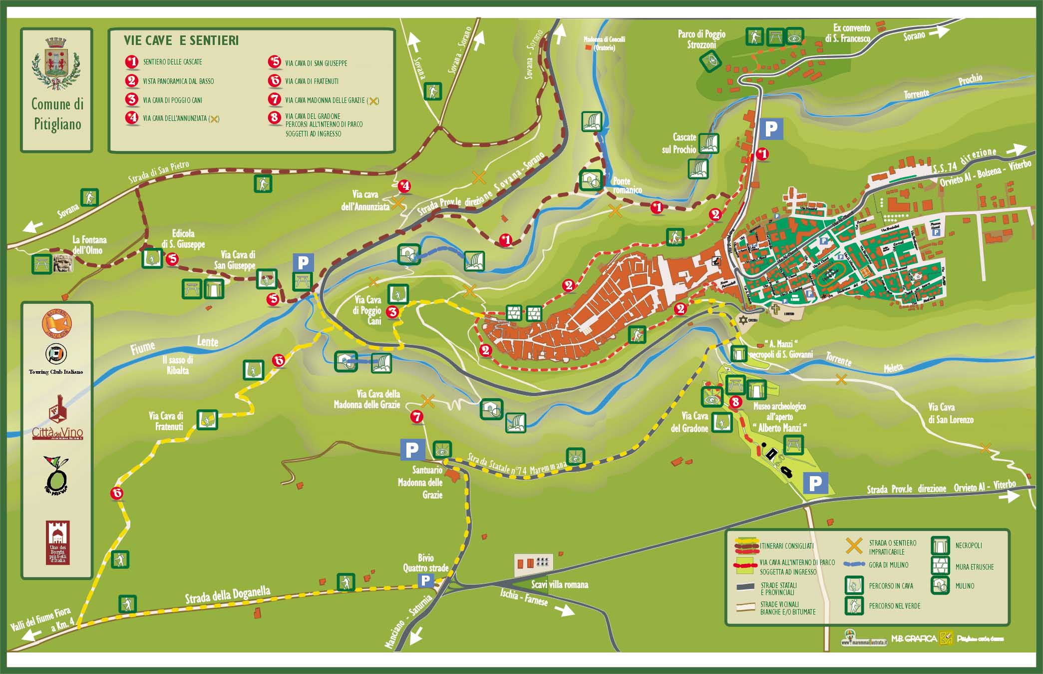
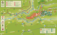
Map of Pitigliano url | pdf
Parco Archeologico Città del Tufo (it)
|
|

Santuario della Madonna delle Grazie, view from Pitigliano
|
| |
|
|
|
|
|
| |
|
| |

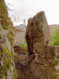
In the outskirts of Pitigliano are numerous the so-called Vie Cave, deep roads obtained cutting the tufacean rocks. Some “Vie” exceed the length of one kilometer, with high walls until 20 meters. The main are that of the Gradone (where it's an interesting open air didactic-informative Museum), of S. Giuseppe, Fratenuti, S.Rocco and the Madonna delle Grazie. Deserves a visit also the archaeological Area of Poggio Buco that accommodates Etruscan tombs of 8th- 7th century BC.
The church and convent of San Francesco is located on the road that goes from Pitigliano to Sorano. Both the church and the convent were rebuilt by the Orsini counts who appointed Antonio da Sangallo the Younger to design the buildings. After the religious orders were suppressed in the nineteenth century the convent was transformed into a farmhouse. The church was destroyed by a fire in 1911, and only a few ruins remain allowing us to identify the outer walls and lateral chapels. Only a series of cloister arches next to the farmhouse are all that remain of the old convent.
Orsini Park. Outside of town on the road to Sorano, just pass a bridge, is the entrance to a park created at the end of the 16th century, in which on the north side you can see statues and stone seats carved from the tuff.
Ischia di Castro is located in the southern part of the fascinating territory of the Viterbo province, a short distance from the famous Bolsena Lake. Much of this town is in fact, part of the Riserva Naturale del Lamone (Natural Reserve of Lamone), one of most beautiful and interesting protected parks in Lazio.
Not to miss are the Church of St. Rocco, a Romanesque building splendidly made and custodian of wonderful works of art and frescoes; and the Chiesa di Sant'Ermete, dating back to the second half of the 18th century. The Palazzo Ducale is a historic building of Ischia di Castro, built by Antonio Sangallo as an impressive fortification that can only be accessed through a door and arch, next to the ancient Fortress and a grand bell tower.
The Santuario della Madonna del Giglio (Sanctuary of the Madonna del Giglio is located just outside the town, immersed in the countryside and home to some precious frescoes and extremely beautiful works of art, including two 14th century frescoes.
Lake Mezzano (Lago di Mezzano) is a small crater lake of volcanic origin. The emissary which leaves Lake Mezzano is river Olpeta, that is an affluent to Fiora.
In the 1980s an archaeologic campaign brought back to light a number of historical and prehistorical findings. Many of those are now exhibited in the Museo della Preistoria e della Rocca Farnese in Valentano.
|
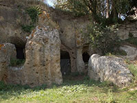
The necropolis of Poggio Buco is located approximately 8 kilometers (5 miles) from Pitigliano heading towards Manciano. Its position made it inviolable: it was naturally protected by tufaceous cliffs on three sides and the one accessible side was protected by a moat. It has a considerable variety of tombs.
An Etruscan community reached its height in the VI century, because of the vicinity of Veio, substituting the nearby centre of Poggio Buco on the Fiora, where the ruins of necropolis and the remains of a temple were rediscovered: around 500 B.C., they were probably destroyed by Porsenna, the King of Chiusi. The Roman presence, with farms and villages on the main roads, show several attempts to build on the plateau in front of the cliff of Pitigliano.
[read more]
|
|
 Necropoli di Poggio Buco Necropoli di Poggio Buco
|
|
|
|
|

Around Pitigliano
|
| |
The countryside in this area of Tuscany is wild and rugged. Densely wooded valleys, rivers and streams, deep gorges and rocky bluffs, sit side by side with olive groves and vineyards.
Tufo is a volcanic porous rock used here for centuries as building material, for stone "bricks" or hollowed out to form tombs, cellars and sunken via cave, pathways. The towns of Pitigliano, Sorano and Sovana form a triangle enclosing the protected area the Città del Tufa.
Besides carving into the tufa rock on which Pitigliano and other towns of this area are built to form tombs and cellars, the Etruscans hollowed out pathways joining their centres - these are known as the vie Cave. Many of these amazing roads - some as deep as 10 meters - can be explored around Pitigliano.
The countryside around Pitigliano, Sovana and Sorano is riddled with vie cave and they make great excursions from any of the towns. Two particularly good examples, half a kilometer west of Pitigliano on the road to Sovana, are Via Cava di Fratenuti, with high vertical walls and Etruscan graffiti, and Via Cava di San Giuseppe, more than 10 meters from top to bottom this pathway passes the Fontana dell'Olmo . This fountain is carved out of solid rock with the sculpted head of Bacchus, the mythological god of fruitfulness, from whose mouth water flows. Via Cava San Rocco is another fine example, near Sorano. It winds its way through the hills for 2 km between the town and the Necropoli di San Rocco.
There are at least 15 rock-sculpted passages spreading out in every direction from the valleys below Pitigliano. These sunken roads or vie cave are enormous, up to 20m deep and 3m wide, and believed to be sacred routes linking the necropoli and other sites associated with the Etruscan religious cult. A less popular, more mundane explanation is that these strange megalithic corridors were used to move livestock or as some kind of defence, allowing people to move from village to village unseen. Every spring on the night of the equinox (19 March) there is a torchlit procession down the Via Cava di Giuseppe which culminates in a huge bonfire in the Piazza Garibaldi (Pitigliano), as a symbol of purification and renewal marking the end of winter.
|
|
Vie Cave around Pitigliano
Via Cava near Pitigliano
|
|
From Pitigliano to Sovana 8 km |
| |
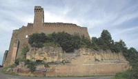
The road circles around Pitigliano's fortress and on to another Orsini fort, at Sorano. The route is lined with caves and tombs cut into the hillside. The medieval village, 379 meters high, is visible long before you reach it, dominated by the Fortezza Orsini and the Masso Leopaldino.
This attractive itinerary, starting from the village of Pitigliano and winding along a track through Etruscan vie cave and hilly sections, brings us to the center of Sovana. After following the road that descends through the centre of Pitigliano, we take Via Aldobrandeschi until, just before it ends, we reach Via Porta di Sovana. Going down, we walk beneath the gate and continue down a beautiful flight of steps, leaving the village behind us until we arrive at the beginning of the two parallel vie cave. We take the right one, via cava di Poggio Cani, that leads us as far as the provincial highway. Here we go on for a few meters and after crossing the bridge over the river Lente on the left we see the signs for a path that climbs up into the woods (signs Via Cava per Sovana and Le Strade del Tufo). This is the via cava dell'Annunziata that leads us as far as the top of the hill over Pitigliano.
Marked red white nr. 3.
Maps | GM, Topographic Map 1:25,000, sheet 333 TAB III – Pitigliano
Multigraphic – Tourist road map 1:50,000 - Maremma
Download pdf
Links
|
|
 Via Cava di San Giuseppe Via Cava di San Giuseppe
 Sovana Sovana
|
| |
From Sovana to Pitigliano 4,5 km |
|
| |
From Sovana go back to Pitigliano and pass the turn of to Pitigliano and proceed to Sorano. Two kilometers before you arrive to the village are the Necropoli di San Rocco. From here you can reach Sorano by foot following a via cava that leads you to il Fosso del Puzzone, il Piano Conati, continue on Via di Poggio Cani further to Pitigliano.
High on a rocky spur, the small medieval village of Sorano has retained its original form. The most important building of the town is the Fortezza Orsini, partly renovated with its museum devoted to the medieval era.
Marked red white.
|
|
| |
From Pitigliano to Gradoli | 18 km, 6,25 hours |
|
|
| |
In the old town centre of Gradoli, there is the massive Farnese palace, designed by Antonio da Sangallo the Younger and ordered by cardinal Alessandro (later pope Paul III) to celebrate the wedding of his son, Pier Luigi, with Girolama, of the noble Orsini family.
The palace hosts the Town Hall as well as the Farnese Costume Museum and the municipal library.
The adjacent parish church of S.Maria Maddalena - a Baroque building with a nave and two aisles - houses a decorated marble baptismal font and a fresco portraying a Madonna and Child, both dating back to the XVI century. Among the thick woods that still surround the church of S.Magno, a few metres from the shore many brigandage events occurred, whose memory is still alive.
|
|
 Gradoli
|
| |
Walk around the magical Etruscan city and the Vie Cave and necropolis of San Giuseppe | 16,55 km | 3h 18m | gpx
Necropoli di Poggio Buco | 3,78 km | 45 min | gpx
Necropoli di Poggio Buco e Selva Miccia | 8,5 km | 1h 42m | gpx
|
|
 |
| |
|
|
Necropoli di Poggio Buco
|
At the boundary between Umbria and Toscany, there is another destination for trekking lovers, which is the Rufeno Mountain, surrounded by wide woods. Quite close is also the Wood of Sasseto with its old tall trees extending till the feet of the Torrealfina castle. The wood is full of rocks standing from the earth beneath, making this forest a striking sight.
For those who prefer an even wilder environment, the ideal place is the Selva del Lamone, close to the boundary of Tuscany. The wood is very thick, quite impenetrable in some areas, but there are many bridle paths allowing the visitor to discover the area either on horseback or on a mountain-bike. Not far away there are also the ruins of Castro and the charming Mezzano lake.
|
La Selva del Lamone ed il Lago di Mezzano
|
|
|
| |
Lake Mezzano is an area of great interest both historically and naturally. The lake was once a volcanic crater and historical site with human settlements going back to the preetruscan era (aprox 2700 years ago), now submerged by water due to earthquakes.
|
|
|
| |
La Selva del Lamone is located just outside the town of Farnese. The Lamone Forest is an impervious and partly impenetrable forest, which extends from the crater of the lake of Mezzano towards the sea, crossed by a single dirt road. The thick vegetation, natural shelter for many animals and rich of wild flowers and mushrooms, is formed mainly by small Turkey oaks and the undergrowth is nearly completely covered by "murce", large stones of different dimensions, inexplicably heaped together. It is told that Hercules, passing through these woods, had been assaulted by a group of robbers ( during the last century, brigands really found shelter here) and Jupiter helped him out with a deluge of stones, which killed the bandits. Many bronze-age settlements, from the 26th to the 10th cent., protected by high walls, have been found in this area, besides the palafitte village in the Lago di Mezzano. There is the possibility of excursions and walks on well marked routes..
Continuing on the course of the Olpeta, in southwest direction, along the equipped path n. 8of the Reserve, it is possible to reach Salabrone Fall, the beautiful fall on the Olpeta river that emerges from an exedra of basaltic lave. The toponym of Germanic origin (Sala = building, Brunnen = well, fountain) and perhaps is going up again to the period of the Longobard occupation of the territory.
Map
Riserva Naturale Selva del Lamone Itineraries (it)
Riserva Naturale Regionale Selva del Lamone | www.parchilazio.it (it)
Natural Reserve of the Lamone | Itineraries through the Farnese territory |
|
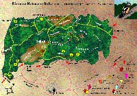 Natural Reserve of the Lamone, map Natural Reserve of the Lamone, map
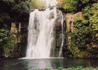
Salabrone Fall
|
| |
|
|
|
| |
The brigands’path which is a tourist itinerary carried through with the GAL and the Comunità Montana Alta Tuscia Laziale funds, involving the whole territory of Northern Tuscia: from the northern Acquapendente borderline to the Castle of Vulci, in Canino. The path crosses the most valuable areas under a naturalistic and historical point of view: the lakes of Bolsena and Mezzano, the Nature Reserves of Monte Rufeno and Lamone Forest, the Etruscan necropolis of Pianezze in Grotte di Castro, another one in Castro and of Vulci, and the Francigena Road.
This is the terroritory where brigands, hated and admired at the same time, blustered for a long time becoming almost a legend. The Maremma brigands’ raids of the end of 19th century are the underlying theme of the path but is also a further occasion to visit and to discover northern Tuscia.
Il Sentiero dei Briganti: la guida | The brigands’path: guide | pdf
|
|
|
| |
|
|
|
| |
Tuscany Holiday Homes | Podere Santa Pia |
|
|
| |
 |
|
| |
|
|