
 |
|
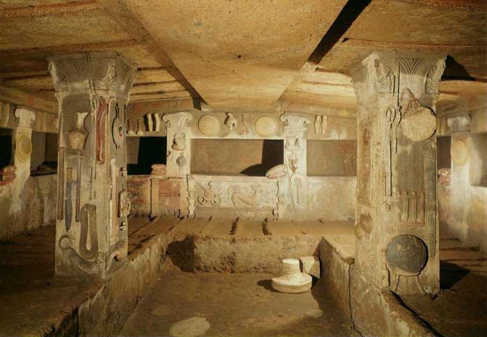
The tomb of Ildebranda, the most famous tomb in the entire necropolis of Sovana |
|
| So powerful was Etruria that the renown of its name spread not only over all the land of Italy, but the sea as well, stretching from the Alps to the Straits of Sicily. Titus Livius |
|
|
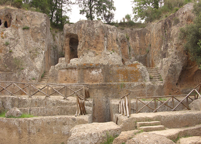
| The Etruscan necropolis of Sovana is just a few kilometers from Sovana. The necropolis is noteworthy not so much for its enormous size, but for the many different types of tombs it contains. We can see tombs dating from the VII-VI centuries B.C. even though the main nucleus (with its more complex and sophisticated graves) was developed in the III-II centuries B.C. Some of the most significant sites in the necropolis are: the “Tomb of the Mermaid” (an aedicula tomb with a portico decorated on the frontal), the “Tomb of Idelbranda” (shaped like a temple with a double stairway and columns with capitals decorated with anthropomorphous elements), the Grotta Pola (with eight columns on the façade) and the Tomb of the Typhon (an aedicula with a decorated tympanum). All the decorations, carved into the tufa, stuccoed and polished were originally painted in lively colors. At the center of the necropolis there is a site where a female goddess of health was worshipped as demonstrated by a votive statue rich in heads, legs and other parts of the human anatomy. |
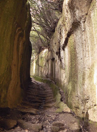
| The Archaeological Area of Sovana is located west of Sovana, along the road leading to San Martino sul Fiora. The most beautiful funereal monuments date back to the beginning of the 3rd century BC, including the large Pola and the Ildebrando tomb, discovered in 1924, datingback to the second century BC and considered the most important monument of the necropolis, if not the most important Etruscan monument excavated to date. In Sovana, you can also experience a walk in the enchanting Vie Cave, imposing walkways excavated from the tufa by the Etruscans, perhaps as communication lanes, perhaps for magic rites. The tombs in Sovana were first discovered in 1843 by English archaeologist S.J Ainsley, who said, at the time, that he had never before seen so many rock-carved tombs in one place. This huge necropolis remains today one of the most important and evocative relics left behind by a civilisation that existed even before the might of the Roman Empire. The Sovanan territory is best known as the location of Via Aurelia and Via Cassia, two principal communication highways that connect to an endless series of small streets and alleys which lead all the way to the Fiora River. These ancient roads are all over Sovana but the most famous ones have to be the Vie Cave. Short in distance, these roads have become so famous simply because of the way they are carved into the volcanic rock. Once used as communication routes, the Vie Cave are covered in small caves and are close to various necropolises. Today visitors can explore these ancient roads hidden in a stunning natural paradise. The archaeological park that houses these roads covers almost the entire Tufo City territory, but it is in Sovana that you will find the most significant ancient treasures. The tombs in Sovana belong to a civilisation that lived in the area between the 7th and 1st centuries B.C. Simple and plain, the tombs are said to belong to the farmers that once lived in the small village. The more elaborate tombs were the ones built between the 3rd and 2nd centuries B.C when Suana was one of the most powerful towns in the territory. The Ildebranda Tomb |
 Cava di San Giuseppe Cava di San Giuseppe
|
|
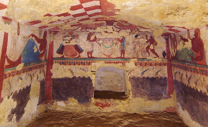
| The Ildebranda Tomb was discovered in 1924. Its unique architecture has earned it the title as the most important and magnificent necropolis monuments not only in Sovana but in the whole Etruscan territory. Archaeologists don’t know who the tomb belongs to but decided to name after the most illustrious Sovanan citizen: Ildobrando di Sovana. Representing the most monumental temple tomb in the necropolis, the Ildebranda tomb is characterized by a front with columns. It was carried out in imitation of a true sacred building with a moulded high podium which was easily reached trough two lateral staircases, and a lacunar ceiling. Originally the monument consisted of six columns with high moulded bases placed on the front and three columns on both sides of the temple. All these columns were characterized by composite capitals decorated with human figure and acanthus leaves. The colonnade supported three tympana presenting a frieze in relief with a series of rosettes and snouts whose tails are held by a female figure. The upper part of the tympanum is decorated with vegetable motives. The monument was entirely covered with polychrome plaster: golden yellow, green and red? A long 'dromos' leads to the burial chamber presenting a cruciform plan and a single funerary bench. Some of the original architectural elements have been reassembled and exhibited in the Pretorio Palace of Sovana.
|
 |
|
Tomba Ildebranda, Etruscan Tomb in Sovana, Tuscany
|
||
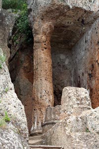
| The Tifone Tomb |
||
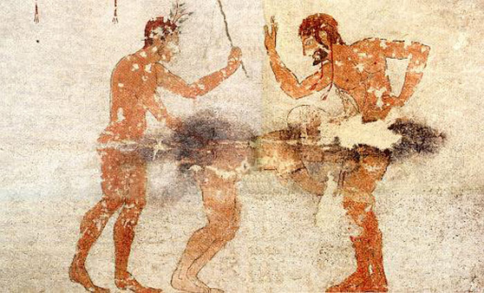
| The Tifone Tomb, located within the Felceto Necropolis, lies off the main path, close to the Ildebranda Tomb but hidden behind a small hill. The tomb is small but embellished with a carved column depicting a human head. During the 2nd century B.C, the tomb was one of the most splendid monuments in Poggio Stanziale. The great head carved in relief is a hellish creature of Etruscan myth and features a classic serpentine form crown.
Il Cavone
|
|
|
Mappa Via Cavone, Sovanai | Ingrandire mappa
|
||
The Folonia Tomb Leaving Sovana and heading for Pitigliano you will find a small but fascinating trail that leads into the woods. Hidden within this trail is a series of tombs that date back to between the 3rd and 2nd century BC. Only a small part of a necropolis was recovered here but all you need to do is take a few steps along the trail and you will be able to see ancient caves and tombs on both your left and right. The Colombari Tomb and Sileno Tomb Upon leaving Sovana from the castle door you will find a small dirt road that leads to the Folonia Tomb. Here you will also find the Monte Rosello necropolis, whose steep ridge is home to numerous rock tombs open to visitors. Among the most interesting tombs is a great columbarium known as the Colombari Tomb and a round-shaped tomb where the bearded head of the Etruscan Silenus was said to have been buried. Pola Tomb The Pola Tomb is located in the Felceto necropolis 300 metres from the Ildebranda tomb and close to San Martino sul Fiora. Once a grand temple, it is today marked only by a single rock-carved column that stands as a living symbol of its past splendor. Siren Tomb |
||
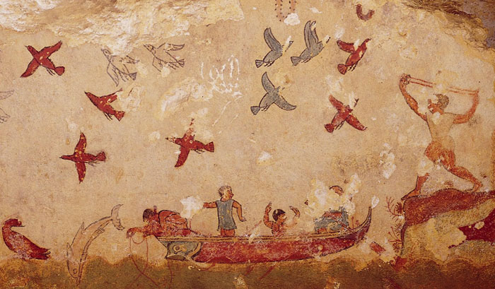
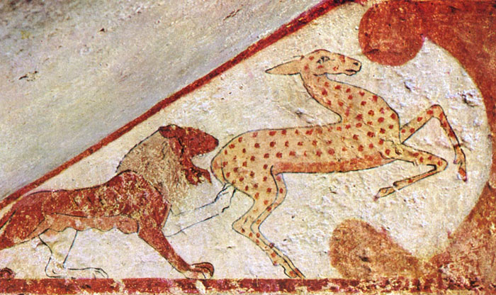
| Passing the tunnel that leads from Sovana to the necropolis, you will find the entrance to the Sopraripa Necropolis. In this necropolis are several tombs which date back to different eras and all of which vary in size and beauty. However, there is one tomb that stands out among the rest and that’s the Siren Tomb. The Sea Goddess from Etruscan myth, the statue on the tomb depicts a mermaid with two tails, flanked by two guards, one which holds a shield and another which wears a very large helmet. No in a good state of preservation, the statues have, over time been eroded by the elements and are almost beyond recognition. On both sides of the tomb are two lions, symbols of infernal deities and placed there to protect the dead. The necropolis of San Rocco in Sorano The necropolis is situated along the tufaceous ridge that defines the valley of the River Lente. It can be reached by following the provincial road that joins Sorano and Sovana. To get there we have to cross the bridge over the river and then go up a series of hairpin curves dug into the tufa. The necropolis consists of chamber tombs carved into the rock that date from the III-II centuries B.C. |
 The necropolis of San Rocco in Sorano |
|
| The Calesina Valley in Sorano |
||
| In January 1950, during the construction of a new road that was to link Sorano with Elmo numerous underground tombs that were part of a large Etruscan necropolis (3) were discovered on the north-eastern ridge of the Sorano plain overlooking the Calesina River. The tombs were arranged one next to the other on homogeneous levels; their depths varied according to the friability of the tufa. The archeological campaign brought to light twenty-thee tombs on a long section of the ridge. With the exception of the furnishings from one tomb that the Carabinieri took to the town hall, all the items found were left in the care of the landowner, Mrs. Ricci-Busatti Cavallini. Other tombs, that had been stripped of their furnishings were also discovered. The technical report, prepared by the chief of the Government Service for Antiquities in Etruria, Maetzke, sheds more light on the features of this huge necropolis. “The ground where the tombs were excavated is the bank of yellowish tufa which comprises the large plateau of inland Maremma. It is generally covered with topsoil and plants…The soil is not homogeneous and compact, it seems to consist of thick layers of different sedimentations that are not very coherent, therefore, frequent cave-ins are common in the tombs…. “The tombs consist of a four-sided chamber ranging from 10 to 16 square meters (12 to 19 square yards) in size which do not exceed 2-2.5 meters (6.5-7 feet) in height, with two benches to hold the body and the burial items that accompanied the deceased. “This chamber is reached via a trench-dromos with slightly scarped walls that lead to a lower portion with a rough arch and enclosed by a wall of uneven tufa blocks. “Beyond the door, a small, 20 cm (8 inches) deep drainage channel runs from the dromos through the chamber. “They are generally lacking architectural elements. Only in one case (tomb 17) the ceiling imitates a pitched roof with a central beam (14). Tombs 7 and 8 are niches with materials similar to those found in the other chamber tombs. The entire cemetery complex had most likely been ransacked and the graves looted of their furnishings in much earlier times. However, enough was left to [allow us to] determine the type of burial items and to date the necropolis. As Lopes Pegna wrote: “We know that starting in Imperial Rome, when precious coins were beginning to become scarce, it became customary to open the Etruscan tombs, by removing the stone access doors at the end of the dromos to take any valuables that could be easily sold.” (3) From the Renaissance on, the tombs were looted of all items of artistic worth and were sold to rich nobles. In 1939 a law was passed prohibiting the dispersion of the national archeological heritage. This was the moment that the “tomb raiders” came into being. “The Etruscan tombs of Sorana were violated and looted during ancient times, when people were seeking precious metal objects; nearly all of the contained pottery as well as some bronze and iron objects. “An examination of the remaining burial items reveals the homogeneity and relative contemporaneity of the entire group of graves that could date from between the end of the VII and the beginning of the V centuries B.C.” |
||
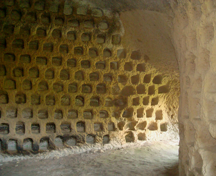
Columbaria |
||
 |
||
Columbaria near Sorano |
||
| The columbaria are one of the typical features of the Sorano area. They are to be found in the lowest part of the village and in the surrounding crags (Columbarie, Rocchette, Castelvecchio and San Rocco). Some consist of rough, uneven niches, but others (at Colombarie) are quite elegant and refined and contemporaries of those built outside Rome during the Augustan age. The collapsing of the tufa makes it impossible to enter many of them, but even in ancient times some could only be accessed via temporary ladders. The entrance consists of a small vestibule that leads to two four-sided chambers with windows; square niches, with curved tops, placed in the walls at even distances. The debate over the use of these columbaria is still open. There are those who maintain that they were used to raise and shelter pigeons, and others who view them as an example of the “Roman burial columbaria”. One very interesting hypothesis takes their location into account. The columbaria are located in tufaceous walls overlooking the River Lente. This river is full of fish, and nearby are woods and pastures so it seems to have been the ideal location for establishing a village that predated the advent of the Etruscans. The village was linked to the land below via a rope ladder that was pulled in every night to protect the inhabitants from enemy raids. The natural position offered the people safety and tranquility. The Etruscans probably used these early cave dwellings for burial purposes because there would have been no reason or advantage in building them in such a difficult position. In fact, the Etruscans generally built their necropolis in easily accessible locations (such at the site at San Rocco). After the Etruscans it is possible that the Romans used them to shelter thousands of carrier pigeons – a business that flourished during their era – but this is only one of many hypotheses. |
||
| The necropolis of Poggio Buco |
||
The necropolis of Poggio Buco is located approximately 8 kilometer from Pitigliano heading towards Manciano. Its position made it inviolable: it was naturally protected by tufaceous cliffs on three sides and the one accessible side was protected by a moat. It has a considerable variety of tombs. The oldest (VII-VI century B.C.) are the fossa type (a rectangular chamber dug into the tufa and covered with slabs). The most recent ones (V-IV century B.C.) are of the chamber type with coffered or pitched ceilings with simulated beams. The Poggio Buco Necropolis, of great interest both historical and landscape, lies on a table-land that is attainable covering at first the state road n.74 from Manciano towards Pitigliano, then at km 9 before the bridge on the river Fiora following the dig road on the right. When you reach the first crossroad follow the road on the right. Continue for about two kilometers until another crossroad marked by a tree. From this point you continue on foot on the left and arrive to the necropolis soon. It will be worth while! It is the place where rose the ancient city of Statonia that had rich life for its commerce and artisan productions until the windward of Vulci. The first traces of takeover go back to the 15th c.- 10th c. B.C., that is to the age of the Bronze as some burial grounds for incineration prove. From the successive period of Iron called Villanoviano (7th c. B.C.) the same place brings traces of a continuative takeover,characterized by a defensive system of which the features of the townwalls are testimony, built in opus quadratum and the ditch with reinforces of tufa blocks. During the 5th c. B.C. the centers that gravitated around the river Fiora met a retrenchment that reduced them to the rank of smaller takeovers with rural character,also the lived area that was on the table-land paid for. Typical of the most ancient period is the pit tomb (fossa) obtained at remarkable depth directly in the rocks.Later it will evolve in grave supplied with one or two loculus gained laterally and closed with tufa slabs. From the half of the 7th c. the room interments do not lack closed with slabs of tufa, preceded by a vestibule which was reached through stairs.Tipology that evolves in the room tomb with cruciform plant constituted of more rooms inside in which the dead people were carefully laid down in graves obtained in the pavement. In some cases the funeral room shows the realistic architectonic partitions, in the first istance the carpentry of the roof, that emulate the inner structure of domestic rooms. The interments of the 8th c.- 7th c. have given back both ceramics painted with geometric decorations or of Etruscan-Corinthian type. |
||
| Walking through the Etruscan necropolis of Sovana | From Sovana to Via cava di San Sebastiano and the Tomba della Sirena (Siren Tomb) | Download pdf [Read more] |
||
Walking through the Etruscan necropolis of Sorano | From Sorano to Vitozza, along the vie cave and the Necropolis of Poggio Felceto (download pdf)
|
||

|
||||
| Parco Archeologico Città del Tufo | Five itineraries |Ildebranda - San Sebastiano - San Rocco - Vitozza - Fortezza Orsini Etruscans The People Who Founded Rome | www.etruscanplaces.net Etruscan Necropolises in Lazio Necropolis of the Banditaccia |
||||
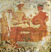
| The most famous attraction of Cerveteri is the Necropoli della Banditaccia, which has been declared by UNESCO a World Heritage Site together with the necropoleis in Tarquinia. It covers an area of 400 ha, of which 10 ha can be visited, encompassing a total of 1,000 tombs often housed in characteristic mounds. It is the largest ancient necropolis in the Mediterranean area. The most famous of these mounds is the so-called Tomba dei Rilievi (Tomb of the Reliefs, 3rd century BC), identified from an inscription as belonging to one Matunas and provided with an exceptional series of frescoes, bas-reliefs and sculptures portraying a large series of contemporary life tools. The Tomba della Rilievi, the only one of its kind to be discovered in Italy, is packed with painted low relief stuccoes of the artefacts of every day Etruscan life. The tomb is of single chamber construction with partitions, balconies, columns and spaces assigned for graves. Also well-worth noting are the Tombe dei Capitelli, dei Scudi and delle Sedie, delle Cinque Sedie and dell’Alcova. |
 The Tomba della Rilievi, Necropoli della Banditaccia, near Cerveteri. |
|||
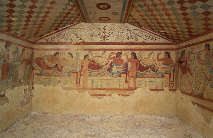
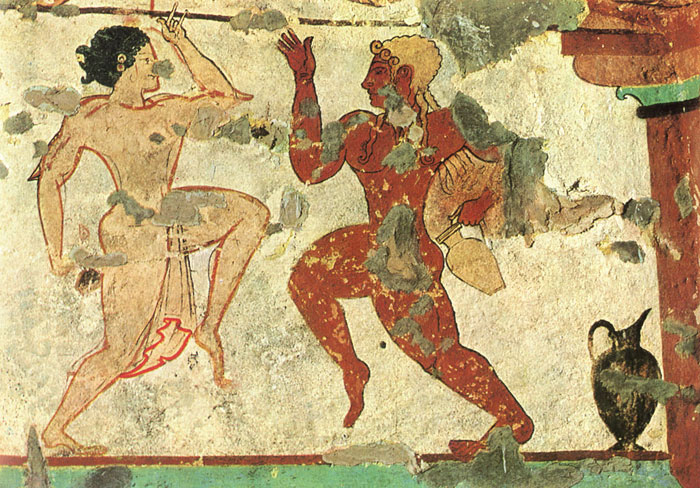
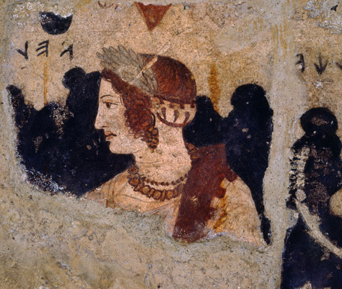
| The necropolis of Monterozzi in Tarquinia Italy’s largest necropolis (750 hectares 3 km outside town) with 6,000 underground tombs (“tomba a camera”). The necropolis of Monterozzi in Tarquinia contains some 200 painted tombs, of a quality indicating the nobility of the people buried there. The images depict everyday scenes, as though to stress a common belief of the afterlife. The surfaces were prepared using lime and then a charcoal sketch was drawn. The decoration was painted in rich vibrant colours using pigments from plants (black, red and green) or minerals (ochre and lapis lazuli). Some figures were purely imaginary (the Etruscans had never seen any lions, just heard about them) or taken from daily life (banquets, athletics, horse-races, erotic games, hunting and fishing). The most important tombs take their names from the paintings: Hunting and Fishing (520-510 BC), Leonesses (late C6th BC), Hunter (C4th BC), Bacchantes (C6th BC), Leopards (470 BC), Jugglers (late C6th BC), Warrior (C4th BC), Charontes (C2nd BC), Trees (C4th BC), Pulcella (C5th BC), Festoons (C6th BC), Bulls (530 BC) and Augurs (530 BC). One of the deepest and largest is the Tomb of the Typhon (mid C2nd BC). The Scataglini tomb (late C4th BC) is particularly complex. Tarquinia | The Necropolises of Tarquinia and Cerveteri
|
||||
 |
 |
 |
||
 |
 |
 |
||
 |
 |
 |
||
| Tarquinia | The Necropolises of Tarquinia and Cerveteri | ||||
The first settlements in the area of Podere Santa Pia go back to the Etruscan and Roman Ages, as testified by the archaeological finds of numerous Etruscan and Roman necropolises. Etrurian fortress of Poggio Civitella at Montalcino |
||||
Enlarge map Poggio Civitella at Montalcino |
||||