Walking in Tuscany | Lago di Burano and Tombola di Feniglia, itineraries between sea and mountains |
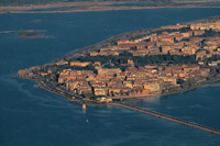
| This promontory harbors the largest lagoon on the Tyrrhenian Sea as well as one of Italy's most important bird sanctuaries. About halfway between Rome and Florence, it makes a wonderful choice for birdwatchers. Take a guided tour of the WWF oases at Orbetello (open Sept. 1-April 30) and Burano (open Aug. 1-May 31) at 10 am and 2 pm on Thursdays and Sundays. Or you can go on your own: for Orbetello drive along the southern edge of the promontory (called Tombola di Feniglia); for Burano Lake take the northern shore road and then walk along the dunes. Or take the 4-hour walk around the coast from Burano to Feniglia. |
|
Walking in Tuscany | Capalbio Burano Lake, Lago di Burano | 7,2 km, 2-3 hours |
||||
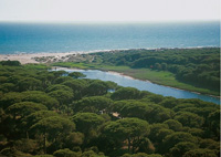
Extending parallel to the coast, Lake Burano and the immediately surrounding district make up one of the most important wetland habitats in Italy in terms of the integrity of the environment and accommodation and teaching facilities. Lago di Burano is a typical Mediterranean coastal lagoon behind a line of sand dunes. A nature trail, with no architectural features to deny access, leads visitors through the various habitats in the sanctuary: from agricultural areas and woodland with oaks of the holm, cork, sessile and downy variety, a residue of the vast tracts of forest that once characterised the Maremma plains, to the dune vegetation at the beach, which is also extremely interesting and rich from the naturalistic point of view. Numerous look-out points allow visitors to observe and photograph the countless bird species that stop off or habitually frequent the reserve: ducks of all kinds, coots, cormorants, herons, little egrets, fish hawks, flamingos and cranes… The scrub is populated by wild rabbits, porcupines, foxes and it is not uncommon to come across tortoises and four-lined snakes. A beautiful Spanish watch-tower with a square plan completes the atmospheric panorama of the lake.
|
||||
 |
||||
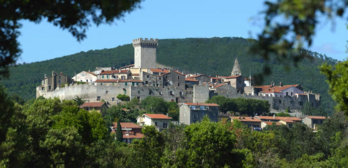
Capalbio |
||||
Located on a hill near Lake Burano, Capalbio looks like a typical mediaeval town: a pyramid structure with an embattled fortress at the centre and a mighty circle of walls. Of particular importance is the Romanesque parish church of San Nicola, 12th century, with fine capitals decorated with vegetable and zoomorphic motifs, the 15th-century Sienese gate and the oratory of Providence, just outside the walls, which contains a fresco by Pinturicchio. Possibly of Etruscan-Roman origin, but having developed in the early Middle Ages, in the last century Capalbio was the realm of bandits. In the environs are two beautiful Roman villas. |
||||
 |
||||
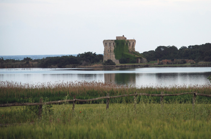
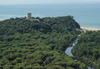
Lago di Burano, Torre di Biranaccio
|
||||
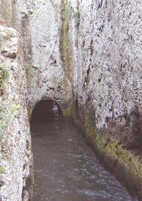
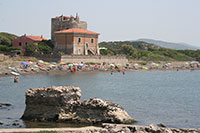
According to various literatures the Spacco della Regina (the fissure of the queen) in Ansedonia, fissure on a rock dedicated to the legendary queen Ansedonia who fell headlong into a pit, was a meeting-place for cabbalistic and orgies of witches and devils. The Tower of Old San Pancrazio, or of San Biagio, was erected from the Spaniards as defence for the port of Tagliata. A little more southwards there is the Tower of Tagliata (XVI century), which was made to create a play of streams to prevent the port from sanding up, by using waters coming from Burano Lake through a canal. That tower was also the residence of Giacomo Puccini, who (together with his friends Collacchioni and D’Annunzio) was deep in the music and affairs. Cosa |
||||
| A massive circuit of walls with a poligonal shape stretching along 1.5 km and provided with 17 watch towers: it’s one of the most ancient ruins in the town of Cosa, a Roman colony founded in 273 B.C.. Cosa is one of the main symbols of the expansion war through which the Romans conquered the Etruscan territories from the 4th century B.C. (Veio was the first Etruscan town to fall under the Romans in 396 B.C.). They conquered Roselle in 294 B.C. and Tarquinia in 281 B.C., and then Vulci in 280 B.C. Within 20 years, Etruria lost its peninsular dominion. After destroying the main Etruscan towns and confiscating their surrounding territory, the Romans offered surviving enemies the opportunity to sign alliance treaties and become Roman colonies within their expansion plan. Cosa, originally founded within the territory of Vulci, is a typical example of Roman colonies: a smaller Rome. The town is immediately provided with new defence walls and an almost impregnable fortress to control the surrounding territory, becoming a very strategic post against possible sea invasions.[1] |
||||
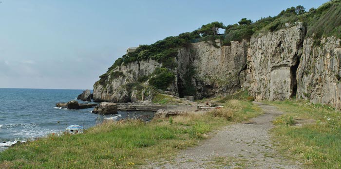
| Tagliata of Ansedonia |
||||
At the foot of the hill occupied by the Roman colony of Cosa (273 B.C.), a port was built and equipped with impressive infrastructures, in part still visible. To prevent the port from silting up and to guarantee a constant exchange of water, a large fissure of the promontory of Ansedonia, the so-called Spacco della Regina (queen’s cleft), was equipped with mobile bulkheads, the recesses of which are still visible in the rock. The wooden doors were opened according to the season, in order to let water in or out of the dock and thus avoid it from stagnating and debris from accumulating.
|
|
|||
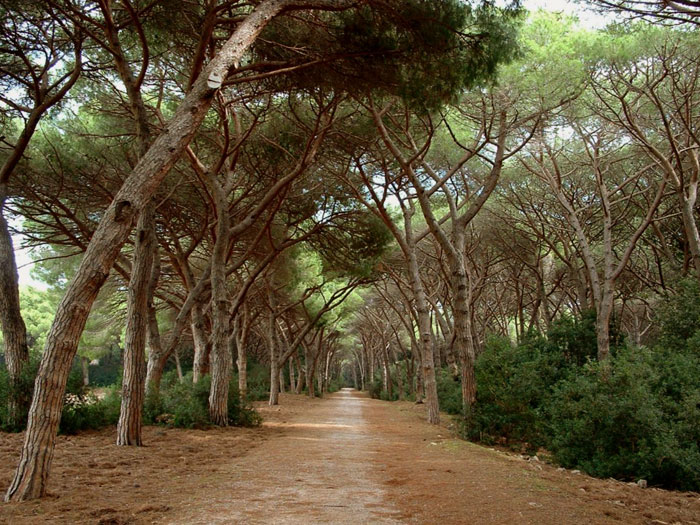
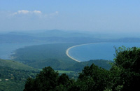
 The cliffs, heated by the Maremma sun, connect the long beach of Feniglia and the Taglia Etrusca, a magnificent channel cut through the rock by the Romans, designed to ensure the flux and reflux of water into the ancient port. Monte Argentario is a heavenly peninsula situated in the southernmost of Tuscany. The peninsula, overlooking both the Tyrrhenian coasts and the Tuscan Archipelago, is formed by an impressing wooded mountain with a surface of more than 60 square kilometres, reaching over 600 metres of highness. Monte Argentario was originally an island, but in ancient geological ages the sand drifts silted the channel forming two strips of land, the Tombolo di Feniglia to the south and the Tombolo di Giannella to the north, joining the former island to the mainland. The largest one is the Tombolo di Feniglia, It stretches out lengthwise for about 7 Km and links the Ansedonia promontory to the slopes of Mount Argentario, with an amazing nature hosting some protected species of wild fauna, as well as an unpolluted extensive beach. The Feniglia beach is one of the most beautiful beaches of Tuscany. The beach is lined with a magnificent pine forest (a protected area known as the Feniglia Tombolo) that runs along its entire length and crossed by an unsurfaced road, ideal for walks and bike rides. You can easily spot deer and occasionally, wild boars. |
||||
Walking in Tuscany | Tombolo di Feniglia |
||||
 |
||||
Pine forest of feniglia |
||||
The promontory of Monte Argentario is connected to the mainland by two narrow strips of sand known as tombolo. In between these tomboli is a brackish lagoon which is a haven tor wading birds. The southern tombolo, is completely closed to traffic and is protected as a nature reserve, established by the World Wildlife Fund. This protected area, the Tombola di Feniglia, is known for its long sandy beach lined with pines and protected lagoons for birds including herons, pink Flamingos and Corsican Seagulls. |
|
|||
|
View Tombolo di Feniglia in a larger map |
||||
The Ramsar Convention on Wetlands
www.wwf.it | Riserva Naturale dello Stato Lago di Burano (it)
|
||||
| Riserva Naturale della Laguna di Orbetello (Grosseto) | Environment, Flora and Fauna in the Orbetello Lagoon Nature Reserve The Natural Reserve of the Orbetello Lagoon is the second one in Italy, a WWF Oasis situated along one of the most important migratory routes. An untouched environment made up by the lagoon, a sandy tombolo, with the maquis, a pine grove, cultivated fields, which hosts a rich fauna consisting of about 200 species of water fowls, with pink flamingos, ducks, herons, grebes and seagulls. In order to admire this splendid Oasis, the WWF organizes guided tours along the “nature paths” fitted out with observation spots and huts equipped with illustrative signs. Oasi Affiliata Capra Matilda (Grosseto) In de comune of Roccalbegna, in Cancellone and in dl comune of Semproniano, in Selvignana. Orbetello
|
|
|||
[1] Source: Parco degli Etruschi | Cosa: when the Romans conquered Etruria [2] Julian Budden, Puccini: His Life And Works, New York: Oxford University Press, 2002.
| ||||

 |
 |
 |
||
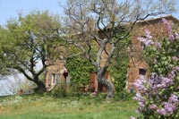
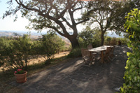
Podere Santa Pia |
Podere Santa Pia |
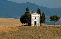
Madonna di Vitaleta Chapel, San Quirico d'Orcia |
||
Tuscany is one of the most popular tourist destinations in the world. Known for its enchanting landscapes, its fantastic and genuine food and beautiful towns as Florence, Pisa, Lucca and Siena. Tuscan farmhouses | Podere Santa Pia |
||||
 |
 |
|||
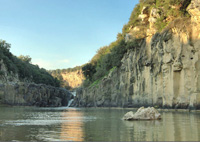
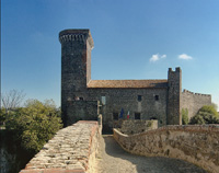
Vulci, Castello della Badia |
The oasis Vulci extends along the river Fiora, where a water fall has originated a small lake, lago Pellicone |
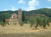
Abbey of Sant'Antimo |
||
 |
 |
 |
||
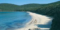
Cala Violina |
The most famous part of the Maremma is the Parco Naturale della Maremma, otherwise known as the Parco dell'Uccellina |
Principina a Mare The Ombrone River located along the coast of Maremma Grossetana, where it flows into the Tyrrhenian Sea in Principina a Mare. |
||
|
||||
 |
||||
Regina Nemni and Christopher Buchholz in Michelangelo Antonion's Il filo pericoloso delle cose |
||||