|
|
|||||||||
 |
||||||||||
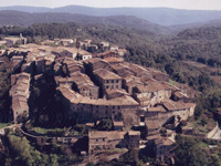
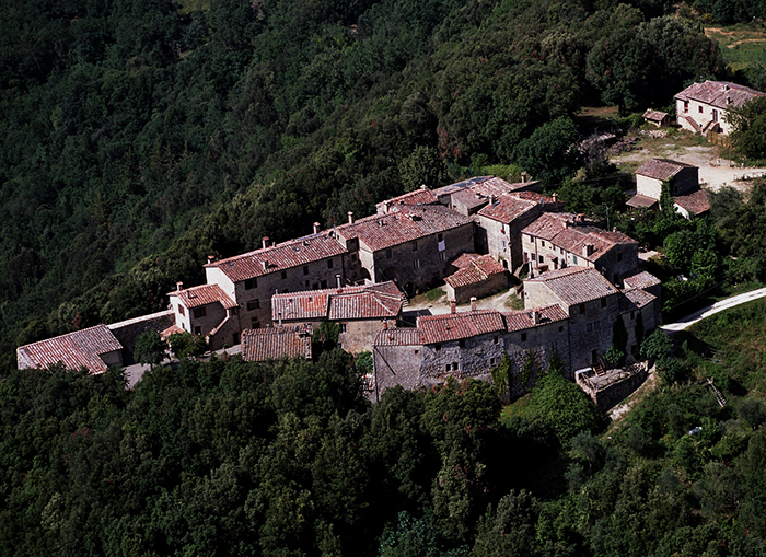
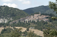
Massa Marrittima |
||||||||||
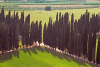
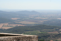
Massa Marittima and the Colline Metallifere, the Metalliferous Hills
|
||||||||||
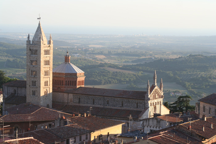
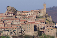
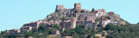
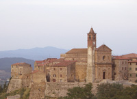
| Massa Marittima | Massa Marittima is one among the most beautiful and picturesque Medieval towns of Tuscany. The town dates back to the XII century a. C. when the Bishop of Populonia, while escaping from the coast and looking for a site protected by the external assaults but also rich of resources to exploit, chose the Monteregio hill, in the upper part of the town, in order to settle there his new residence. It’s not by chance that Massa Marittima got a key position in controlling the territory’s ore bodies, today known under the name of Metalliferous Hills. Of probable Etruscan origin, the city conserve many monuments of its more prosperous period. The city is subdivided in three parts, the low part (or old city) where predominate the Romanesque style and the high part (or new) but founded in 13th and 14th centuries and the Borgo. Piazza Garibaldi, considered one of the most mature examples of medieval urban Tuscany, where almost all of the major civil and ecclesiastical monuments stand out: the Duomo, one of the most refined sacred buildings of Tuscany, the Palazzo Pretorio and Palazzo Communale. The Albero della Fecondità or Tree of Fertility is a peculiar fresco found on one of the walls of the Fonti dell’Abbondanza, one of Massa Marittima’s main public fountains located on Via Ximenes to the left of the Duomo. It depicts a majestic tree with long roots that rise up to the cusp of the vault with branches and a large number of leaves and male genitalia. In May, Massa Marittima celebrates the biannual Balestro del Girifalco (Falcon Crossbow Contest), one of the biggest and most impressive festivals in Southern Tuscany. The Balestro del Girilalco was first held on 8 September 1402. |
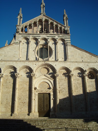 Duomo, dedicated to San Cerbone Duomo, dedicated to San Cerbone |
||||||||
Trekking in Tuscany in the Montioni Park, Etruscan Coast
|
||||||||||
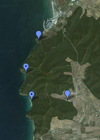
View Montioni Park Trail Starts in a larger map |
||||||||||
Parco Archeologico del Lago dell'Accesa |
||||||||||
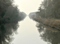
A natural addition to the city tour is a visit to the excavations of the mining village of Accesa, an ancient Etruscan centre located 10 km from Massa Marittima, which can be reached turning off the road for Gavorrano in the locality of Pesta.
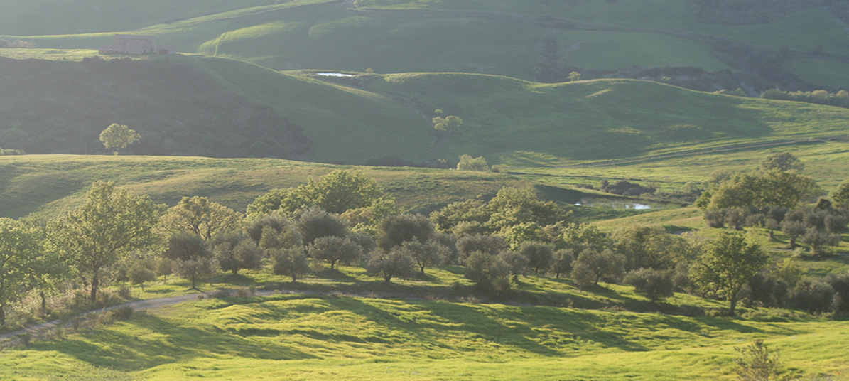
In the midst of a dense woodland area near the Lago dell’Accesa, lie the remains of an ancient Etruscan town, which is still being excavated. The settlement, divided into quarters, was one of a series of small towns in the 6th century B.C. in the area of influence of Vetulonia, sited along itineraries tied to mining activities in the area. The dell’Accesa area is outstanding for having yielded copious evidence of what is today acknowledged as one of the few known urban centres of Etruria.[2] In between Podere Santa Pia and Massa Marittima, Paganico and Campagnatico are well worth a visit. |
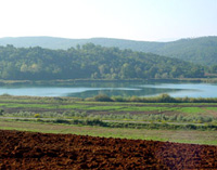 Lago dell'Accesa |
|||||||||
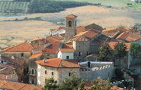
| Campagnatico is fascinating town in the Maremma, located in the south of Valle del’Ombrone, on the border of Tuscany’s newest up and coming wine area, the Monte Cucco DOCG. The ancient area of Campagnatico is surrounded by walls and square towers. Among the great architectural accomplishments of the 15th century is the Chiesa della Misericordia, still visible today. Of special historical and architectural interest is the Pieve di San Giovanni Battista, of Romanic-Gothic style, charcatherized by a vela, a bold bell tower. Inside the Pieve, frescoes of the late the 13th century. |
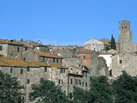 Campagnatico |
|||||||||
| Civitella Paganico | Paganico is an ancient fortified town built by the Sienese to protect the Ombrone valley and the access to the hills of Siena. The medieval walls are perfectly preserved and the apse of the Chiesa di San Michele Arcangelol houses beautiful frescoes by Biagio di Goro Ghezzi. Comune Civitella Marittima, Paganico, Casenovolo Casal di Pari and Pari belong to the municipality of Civitella Paganico. Bagni di Petriolo with the thermal spas Terme di Petriolo are nearby. The hermal baths of Petriolo |
 Castello di Casenovole, view from Civitella Marittima |
||||||||
| Casenovole | Monte Antico and Castello di Casenovole
In the comune of Civitella Paganico, there are two other picturesque castles in a nice panoramic position: the Castle of Monte Antico and the Castle of Casenovole |
|||||||||
| Roccastrada | Roccastrada is a fairly ordinary place distinguished by the beautiful 13th century church of Saint Nicola in the old part of the town. The Town Hall, the Municipal Library and the Theatre of the Concordi are located in the 19th century new part of the town. Roccastrada, a village in the heart of the province, is starting point of a wide net of more than 150 km pathways leading through this area full of natural beauty and historic locations.
|
 Roccastrada, view on the Val d'Orcia |
||||||||
| Roccatederighi | Roccatederighi is one the Maremma's most interesting medieval villages. The village of Roccatederighi is located on a spur with spectacular views over the plains of the Maremma below. Situated at an altitude of 538 m above sea level and hidden amidst gigantic rocks of rhyolite, called masses, its profile marked by towers and rooftops stands out perfectly against the surrounding nature and countryside. The fortification La fortezza sits on the highest point of the village and while there remains little of the medieval walls, the tower has been restored.
|
 Roccatederighi Roccatederighi |
||||||||
| Montemassi | The castle of Montemasi is, without any doubt, the most famous monument in the territory of Roccastrada, for its importance of historical document (it was represented on the famous fresco situated in the public palace of Siena attributed to Simone Martini) and for the high example of Gothic style architecture that it represents.
|
  |
||||||||
| Torniella | The little mediaeval town of Torniella, dating from the 11th C, is located in the Alta Maremma in the county of Roccastrada, among woods and forests on the border between the provinces of Siena and Grosseto. The castle of the Ardengheschi, the vassals of the Aldobrandeschi, forms the stronghold of the town.
|
|||||||||
| Prata | In the frazione of Prata are a medieval castle with two towers and the Pieve of Santa Maria Assunta. The walled borough of Tatti includes the medieval church of San Sebastiano. |
|||||||||
| Gerfalco | The village of Gerfalco belongs to the municipality of Montieri. There is a well marked network of hiking trails. A wild-romantic path leads to the former silver mines, from where there is a wonderful view to the sea and over Maremma Tuscany. Riserva Naturale Cornate e Fosini The Reserve is situated in the west of the town of Chiusdino, in the eastern part of Colline Metallifere, and includes one of the few mountain areas of southern Tuscany. Walk from Gerfalco to Castello di Fosini and the Poggio Mutti. Other interesting villages in the area are Monterotondo Marittimo, completely immersed in the woods. Near the village, the medieval Sanctuary of Frassine is one of the few churches in the Maremma dedicated to the Holy Virgin. |
 |
||||||||
| Montieri | ||||||||||
| Monticiano | Monticiano, a very old village which dates back to the 12th century, is located in a beautiful area, in the heart of a valley between the river Merse and the river Farma. The oldest part of the village is located on a hilltop, within the remains of the ancient walls. From the top of the hill the view over the valley of the river Merse is breathtaking.
|
|
||||||||
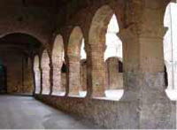
| Chiusdino L'Abbazia di San Galgano |
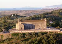
The abbey of Saint Galgano, with the Montesiepi hermitage rise in the valley of the river Merse, between the medieval villages of Chiusdino and Monticiano. The site is made up of two major attractions: the gothic roofless cathedral (1224) and the unusually shaped monastery of Montesiepi, and ancient hermitage, which hosts the tomb of San Galgano and the sword in the stone. The Abbey of San Galgano was built in the 13th century when the old chapel and monastery became too small for the pilgrims who visited the tomb of the saint from Siena. L'Abbazia di San Galgano was Tuscany's first pure Gothic church, and it was later used as the model for the Cathedral of Siena.
|
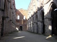 L'Abbazia di San Galgano |
||||||||
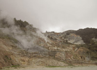
| Monterotondo Marittimo | One can't miss the biancane or soffioni, volcanic vents that emit jets of steam and contain a small proportion of boric acid, near Monterotondo Marittimo. The Maremma Natural Park is one of the most interesting and diverse in Italy and well worth a trip. The Park begins at the mouth of the Ombrone river area, rich with vegetation and marshes, like la Trappola, a series of shallow ponds separated by sand dunes and thick canes, home of many bird species, some of which are very rare like the beautiful Cavalieri d’Italia with their white body, the black wings and long fire-red legs. |
 Monterotondo Marittimo |
||||||||
| Bolgheri | In Bolgheri, a hamlet belonging to the Municipality of Castagneto Carducci, you can find one of the main natural parks, the WWF fauna oasis. Bolgheri is also famous for hosting some of the most prestigious wineries in the world. Some of best Italian wines come from these hills towards the sea, i.e. Sassicaia, Ornellaia, Grattomacco, Paleo, Masseto, Messorio, Scrio and Guado al Tasso. The picturesque village was built around a medieval castle situated on a small slope at the end of the 5-km cypress way. The latter starts from the via Aurelia, before the XVIIIth-century Oratorio of San Guido. This place has been mentioned and immortalized by the lines of Giosué Carducci in the famous poem “Davanti a San Guido” (1874). The closest train station is on the outskirts of the town but there are many departures to the nearby town of Cecina. |
|||||||||
| Campiglia Marittima | Campiglia Marittima is a renowed and well equipped seaside resort, with wide and beatiful pinewoods, an efficient touristic harbour and a fantastic acquatic park. With its narrow streets and the houses all gathered around the castle, this typical medieval village, has a very ancient history. An urban settling had been probably existing there since the Etruscan age.
|
|
||||||||
| Castagneto Carducci | Castagneto Carducci is located in the heart of what is called Costa degli Etruschi, on a graceful hill dominating the sea. Plunged into the green Tuscan countryside, Castagneto Carducci is a charming medieval village, that has been founded around the Castle of the famous Della Gherardesca family, built in the year 1000. The castle dates from the 11th century and is still occupied by the old noble family. Its original name was Castagneto Marittimo. However at the beginning of 1900, it was named Castagneto Carducci, after the famous poet Giosué Carducci. |
|||||||||
| Suvereto | Suvereto is an evocative medieval village with its circuit of walls still intact, situated but a short distance from the Etruscan city of Populonia. From the village the eye takes in the Tyrrhenian Sea, the Gulf of Follonica and, beyond, the island of Elba. The city walls of Suvereto still encircle the small town. Suvereto is one of the Etruscan Coast's most beautiful villages, nestled among the coastal hills and surrounded by ancient forests of cork (the Italian name for cork trees, sughero, is the source of the town's name), chestnuts, oaks and Mediterranean scrub it is rich in artistic treasures as well. In 1201 the town received its Charta Libertas and became an independent town state. One of the Maremma area’s most outstanding examples of medieval architecture, Il Palazzo Comunale, dates back to this time.
|
 Suvereto, cloistro |
||||||||
| Piombino | Piombino town (Livorno) is from where set out the ferryboats to the Island of Elba. Piombino has an ancient historical center, derived from the time in which it was the Etruscans' port, in the surroundings of Populonia. In the Middle Ages, it was instead an important port of the Republic of Pisa. Its hinterland hosts a considerable industrial area. Its port is still heavily used, both for industry and for tourism, with ferry-boats to Portoferraio (Elba) and Olbia (Sardinia). The name Piombino derives almost certainly from Populino, meaning "Small Populonia", which the refugees gave to a small village where they had taken refuge after the city had been attacked by Greek pirates (9th century CE). It is also probable that Piombino had already been founded during the Ostrogoth domination. The Cassero Pisano(Castle). It is formed by two distinct building, the Fortress, built under Cosimo I de' Medici (1552–53), and the Cassero (late 15th century), the latter used as military jail until 1959. |
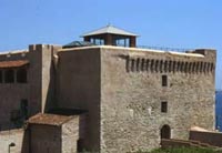 Piombino Castle |
||||||||
| Coastal Park of Sterpaia | Coastal Park of Sterpaia |
|||||||||
| The Etruscan Coast territory in Tuscany has much to offer hiking enthusiasts, or those who simply love to walk, with its spectacular fine sand beaches, natural oases, bushland parks and natural uncontaminated environments. The Coastal Park of Sterpaia extends over 296 hectares, out of which 17 hectares of sandy shores extending over 10 km, 124 hectares of dunal and retrodunal areas, 155 hectares of wood and agricultural glades. This park is formed by bushland and a coastal area with characteristic fine sand dunes, situated along the stretch of coastline between Piombino and Follonica. The Park of Sterpaia is ideal for walks or mountain bike rides, combining the pleasure of hiking through bushland with century old oak trees, with the pleasure of swimming in the crystal seas of the Gulf of Follonica, with all the typical natural features of the Maremma Livornese. The purity of its waters and the numerous services available for swimmers have ensured this area has been awarded the “Bandiera Blu” (Blue Flag) for several years. Walking in Tuscany | The Coastal Park of Sterpaia
|
 Fosso Corniaccia |
|||||||||
|
View The Coastal Park of Sterpaia in a larger map |
||||||||||
| Follonica | Follonica is essentially a very pleasant and popular seaside resort, located at 40 kilometres northwest of Grosseto. Situated on the Gulf of Follonica (Golfo di Follonica), Follonica offers wonderful landscapes from Punta Ala in the south-east to Piombino in the Northwest and towards the sea, until Elba island. | 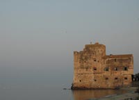 Torre Mozza Torre Mozza |
||||||||
| Inside the Follonica Gulf, in the heart of the Natural Reserve of the Bandite of Scarlino, which is divided by a small promontory from Punta Ala, among a multitude of small caves, you will find Cala Violina. La Riserva Naturale delle Bandite di Scarlino has an adequate and efficient net of signed paths for trekking and mountain bike. The most beautiful path of the area is without a doubt that of the Costiere whose access is possible only on foot, on horse or in bicycle, it pass through beautiful rocky coves of certain beauty, like Cala Francese, Cala Martina, and Cala Violina. Cala Violina attracts in every period of the year, but in the summer, an exorbitant number of tourists overrun the beach, and you are baffled by the number of boats that are anchored beyond the floaters delimitating the beach. |
||||||||||
| Scarlino | From Scarlino to Portiglione - 10 km
From Portiglione to Torre Civette and Punta Ala - 11 km
From Torre Civete to Portiglione through the Val Martina - 9 km
From Val Martina to Cala Violina - 3.5 km
|
|||||||||
 |
||||||||||
Cala Violina |
||||||||||
| A walk close to the sea, towards Cala Violina and Cala Martina |
||||||||||
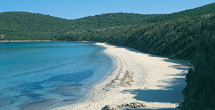
The beach of Cala Violina is perhaps the most beautiful bay of all of Tuscany. The beach owes its name to the particular nature of the fine white sand it has which tends to produce a "violin-like" sound when you walk bare foot on it. It is enclosed in two different headlands covered with the Mediterranean Vegetation, Cala Violina is also renowned for its transparent waters and fabulous seabed with rows of Posidonia Oceania and masses of sandstone and fish of any dimension.
|
 A walk close to the sea, towards Cala Violina and Cala Martina |
|||||||||
| Gavorrano | Gavorrano is located on the northern slope of Poggio Ballone, east of Scarlino, in an area extremely rich in terms of mining, especially for large deposits of pyrite which were intensively exploited until the early 1980s.
|
|
||||||||
| Sassetta | Not far from Sassetta, a beautiful, unspoilt village in the Val di Cornia, 10 km from the sea, the forested nature park of Poggio Neri offers a variety of itineraries for different interests. The Poggio Neri park consists of an extensive hill forest dominated by holm oak and chestnut, and offers many opportunities for open air leisure activities. To promote the rediscovery of this fascinating area, the park has created well-signed trails for hiking.
The Museum of the Wood
|
|||||||||
|
||||||||||
| Caldana | The Church of San Biagio, a rare example of sacred Renaissance architecture in southern Maremma, was recently recognised as national monument. The church was commissioned in the 16th century by the Agustini family from Siena, whose coat-of-arms can still be seen at the centre of the pediment. Its similarities with some parts of the church of the same name in Montepulciano, especially as regards the façade, would seem to attribute it to the school of Antonio da Sangallo the Elder, even if recent studies, which are still in progress, would appear to attribute it to Michelangelo. Inside the church is the high altar fresco by Giuseppe Nicola Nasini, which depicts Saint Biagio and Saint Guglielmo adoring the Crucifix, while two canvases portraying Saint Luca with the Madonna with Child and the Assumption of the Virgin can be attributed to Sienese artists of the first half of the 17th century. The 17th century stoup is in local marble known as “Portasanta”. The thermal waters of the Valle del Sole Spa come from the hot springs of Caldana. Both the Etruscans and the Romans knew of the therapeutical effect of this springs. The Spa water has a natural temperature of 45? and comes from a crater in Caldana while the swimming pool water comes from the springs of Canneto . |
 Caldana |
||||||||
| Vetulonia | Vetulonia, formerly called Vetulonium (Etruscan Vatluna), was an ancient town of Etruria, Italy, the site of which is probably occupied by the modern village of Vetulonia, which up to 1887 bore the name of Colonnata and Colonna di Buriano: the site is currently a frazione of the comune of Castiglione della Pescaia The wide necropolis of Vetulonia features incineration and inhumation tombs, grouped by “continuous circles”, each consisting of a tumulus of beaten earth with a diameter of 20-30m, bordered by flags of stones vertically arranged. A wide range of funeral offerings were also found. The necropolis includes large monumental burials with dromos and covered chambers with fake tholos domes and central pillars. One of the most representative examples of these tombs can be seen along Via dei Sepolcri: it’s the Tomb of Pietrera (7th century B.C.). Here archaeologists found some of the most ancient examples of in-the-round Etruscan statues made of stone. Museo Civico Archeologico di Vetulonia "Isidoro Falchi" Isidoro Falchi, the Archaeological Museum of Vetulonia, just a few minutes’ drive from Punta Ala, describes the area's history through the archaeological finds uncovered in Vetulonia and the surrounding areas. |
|
||||||||
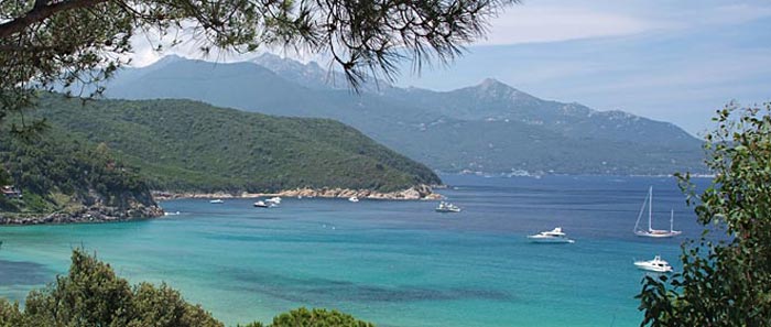
| Elba | The Island of Elba is the third largest Italian island after Sicily and Sardinia and is the largest in the Tuscan Archipelago. It has recently become part of the Tuscan Archipelago's National Park together with the islands of Pianosa, Capraia, Montecristo, Giglio and Giannutri. Elba has a coastline of 147 km: its main mountain (Monte Capanne) is 1019 metres high, accessed via pathways or by a panoramic cable car. Already in acient times Elba's destiny was always deternined by two factors: its strategic position and the richness of its mineral resources. Due to these characteristics, it was often the object of conquest for the various powers along the Mediterranean. For the Etruscans and the Romans Elba represented an inexhaustible source of riches and the iron from Elba contributed to the prospering of their civilazation. |
|||||||||
| Tuscan archipelago | The Tuscan archipelago is a chain of islands between the Ligurian Sea and Tyrrhenian Sea, west of Tuscany. The archipelago contains the islands of Elba (the largest island of the group), Pianosa, Capraia, Montecristo, Giglio, Gorgona and Giannutri, all of which are protected as part of the Tuscan Archipelago National Park. According to legend, the Tuscan Archipelago originated from a jewel that slipped off Venus’s neck, the goddess of beauty and love, and fell into the Tyrrhenian Sea. |
|||||||||
Enlarge map Massa Marittima and the Colline Metallifere |
||||||||||
|
||||||||||
|
||||||||||
 |
||||||||||
Isola d'Elba |
||||||||||
|
||||||||||
|
||||||||||
[2] Parco Archeologico del Lago dell'Accesa ["Lago dell'Accesa" Archaeological Park] | www.brunelleschi.imss.fi.it
|
||||||||||
This article incorporates material from the Wikipedia articles Gavorrano and Piombino, published under the GNU Free Documentation License. |
||||||||||