|
|
||||||||||
|
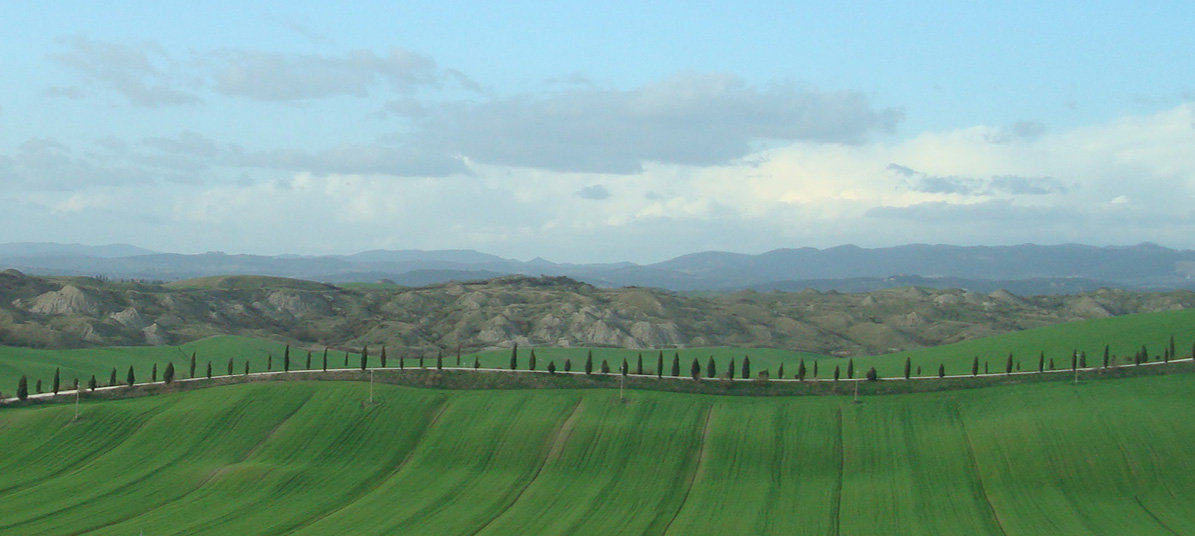
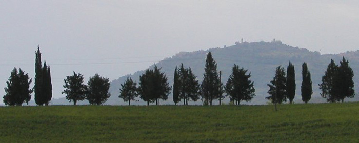
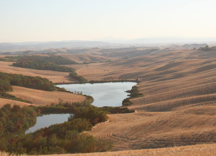
Southern Tuscany is an undiscovered jewel. The territory known as the Crete Senesi contains all of those things which we have come to associate with Tuscany: a landscape of gently undulating hills, lined with cypress trees and covered by a patchwork of fields, olive groves and vineyards. |
|||||||||
 |
||||||||||
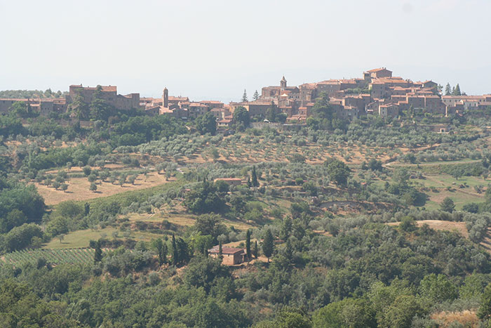
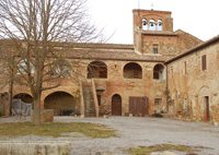
Montalcino, surroundings |
||||||||||
| Montalcino is a charming walled town set above set in a panoramic
position above olive groves and vineyards which produce the excellent
Brunello wine. Perhaps because of its geographic position, far away from the crowded main roads and lacking big industrial poles, here a virtually untouched and to a large extent wild landscape endures. The territory of Montalcino, symbol of this magical rapport between man and nature, was declared in 2004, with the four municipalities of Castiglion d’Orcia, Pienza, San Quirico d’Orcia, Radicofani, a UNESCO World Heritage Site. Only the northeastern end of the territory of Montalcino was affected by the passage of the Via Francigena, corresponding more or less to a stretch of the Via Cassia prior to its recent rectification. Still within the boundaries of the Commune of Buonconvento, in the direction of Montalcino, one can take a detour on the right. After approximately one kilometer, there is an unpaved road on the left which leads to the Altesi Castle, once belonging to the Tricerchi family, as proven by some stone coats of arms;. One of them is dated 1441. At the center of the Altesino estate rises the 14th-century Palazzo Altesi, a visual testament to the estate's prominence. lt is a monumental, square-planned, brick fortalice with two courtyards, corner towers, high scarp base in stone and double lancet windows with pointed arches on three sides. Returning to the intersection we take the dirt road for Badia Ardenga. In the Middle Ages it was seat of an important Benedictine abbey which was passed to the Vallombrosian Order in the 13 th century The present-day church, with late-Rornanesque features and a single nave, is the result of extensive remodeling that resulted in the tearing down of the apses and side aisles. The surviving structures of a more ancient crypt dating back to the 11th century are preserved underneath, partly accessible from the interior of the church and partly from the exterior. Considering its framework with seven small naves sheltered by roman vaults, it must have originally been the largest crypt in southern Tuscany second only to the one in the Abbadia di San Salvatore at Amiata. Although quite altered, the old monastic rooms are also very suggestive and set in lovely surroundings. At this point we can reach Montalcino directly by a long, unpaved road that connects to the one coming from Buonconvento, or by taking the Cassia again where we left it and continuing towards Torrenieri. This was once an important castle, center of a hospital and stopping place on the Via Francigena mentioned in the Archbishop of Canterbury's itinerary. There are still fortified structures in brick with corner towers and scarp bases located on the outskirts of this modern town. The Church of Santa Maria Maddalena houses a wooden statue painted at the beginning of the 15th century. From Torrenieri a beautiful panoramic hill overlooking the Orcia, Asso, and Ombrone valleys, where grain-cultivating fields gradually fade into vineyards and olive groves, a road leads to Montalcino.[1] Trekking in Toscana | Da Buonconvento a Montalcino | Montalcino - Abbazia di Sant’Antimo | Da Montalcino a San Quirico d'Orcia (Italian)
|
|
|||||||||
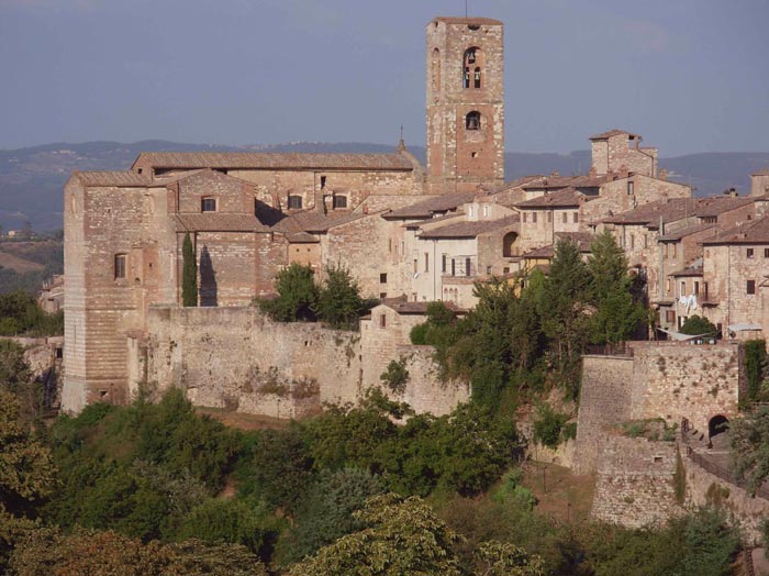
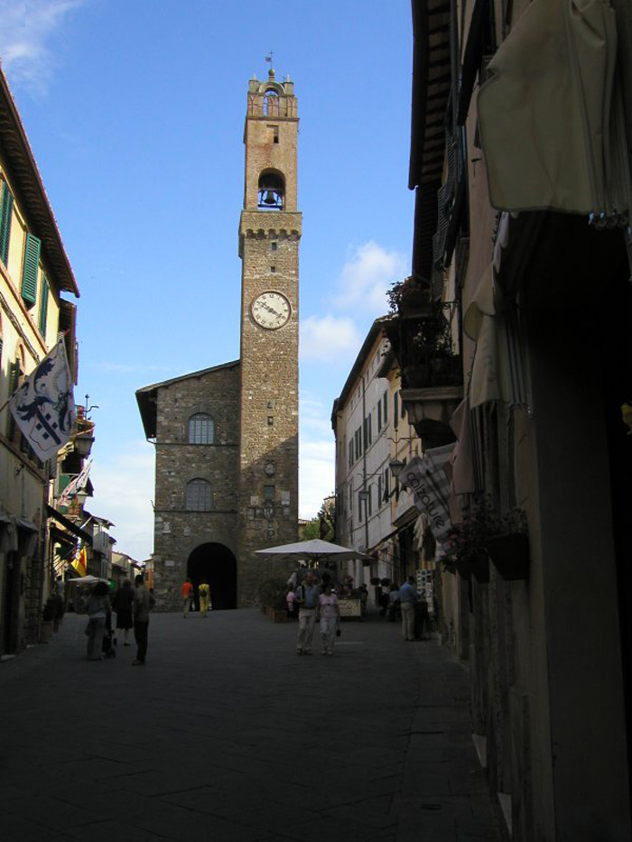
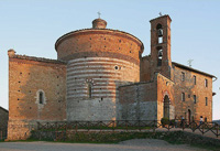
| Montalcino Gates | Numerous monuments are evidence of the important role that Montalcino glayed in the Middle Ages.[2] The 14th century Fortress, with pentagonal enclosure in stone, has high scarp walls provided with loopholes, merlons and corbels, corner towers and a typically Sienese entrance doorway. Inside, the remains of the Romanesque Church of Sant'Egidio are found, as well as a large donjon with access to the patrolling bay, which is entirely practicable. The focal point of Piazza del Popolo is the Palazzo Communale (Town Hall), with portico on the ground floor and slender stone tower with brick belfry. On the opposite side there is a 14th-15 th century loggia with semicircular arches in brick and Sienese arches in stone. Two churches with considerable Gothic characteristics are the Augustinian church dedicated to Saints Philip and James, commonly called the Church of Sant'Agostino, and the Church of Sant'Egidio, which is said to have been carried out by the Sienese in substitution of the one that was demolished in order to erect the Fortress. The first church has a large nave with wooden roof trusses, a quadrangular apse and frescoes dating back to the 14th century partially attributed to Bartolo di Fredi. The second church has a nave sheltered by wooden trusses on transverse ribs, with building materials originating from a previous Romanesque church. The other churches were founded, or their architectural features extensively renovated during the Modern Age, proof of considerable building activity even after the Middle Ages: San Francesco, San Lorenzo in San Pietro, Corpus Domini, Sant'Antonio Abate, Santa Maria delle Grazie, La Madonna del Soccorso, Santa Maria dell'Osservanza (on the road for Torrenieri), and so on. The Duomo was also entirely rebuilt during the 19 th century, though it still houses some sculptural remains originating from the San Salvatore Parish Church, founded at the end of the 10 th century in place of an ancient baptismal church. The artistic heritage preserved in the Civic and Diocesan Museum of Religious Art, located in the former convent of the Augustinians, is truly exceptional. Among the works that were created during the Middle Ages there are an illuminated Bible, a wooden Cruciiix from the second half of the 12th century, a Madonna and Child from the second half of the 13 th century and numerous panels and wooden sculptures from the 14th and 15 th centuries, including masterpieces by Simone Martini, Ambrogio Lorenzetti, Bartolo di Fredi, Giovanni di Agostino, Giovanni di Paolo, Francesco di Segria, Luca di Tommè, Sano di Pietro, il Vecchietta, and Francesco di Valdambrino.[1].
|
|
||||||||
 |
||||||||||
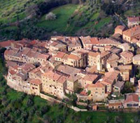
Castelmuzio |
||||||||||
Walking through the rolling hills of the Crete Senesi
|
||||||||||
The best paths in the Crete Senesi
|
||||||||||
| Castelmuzio is off the beaten path, the wonderfully preserved medieval hamlet is set in a luscious landscape , rich with gray-green olive groves, geometrical vineyards, and breathless punctuations of tall slender dark green cypress trees. Castelmuzio dates back to the time of the Etruscans, and is built on a volcanic limestone hilltop. Over the years it has been called by several names, Castel Mozzo and later Castello. You can see the old city walls and ramparts, including the embrasures through which cannons were fired. The village includes three churches. The most famous is the Pieve di Santo Stefano in Cennano, just outside the village. The beauty of Castelmuzio is savored best by meandering the secondary unpaved roads, the strade bianche, that wend their way through the hills.Nearby, Montisi, Petroio,Trequanda and San Giovanni d'Asso, offer museums Trequanda stands on the top of a hill, deep in unspoilt countryside of woods, vineyards and olive groves. Trequanda is quite a small town, and the main attractions are located all around the center, the Piazza B. Cacciaconti. The Piazza is surrounded by many historical buildings and old monuments. The church of Saint Peter and Andrew is one of the most important religious places in Trequanda. The church was first built in the 13th century and is an interesting place to visit. The façade of the church has an interesting stone façade that resembles a black and white check board. The interior of the church has been beautifully decorated with several frescoes made by various popular artists. Close to the altar is a beautiful triptych made by Giovanni di Paolo. The nature train is an interesting celebration that is held in Trequanda every Sunday from May to October which passes from the various scenic locations in the province of Siena and offers a chance to visitors to explore and appreciate the natural beauty of the surrounding landscape. Sant' Anna in Camprena, is an ancient convent between Pienza and Castelmuzio. The monastery was chosen for filming some of the most famous scenes of The English Patient by Anthony Minghella. A long avenue of cypress trees leads to the monastery, all surrounded by an amazing natural landscape. The monastery contains remarkable frescoes by Sodoma. Località Sant' Anna in Camprena, 53026, Pienza, Toscana East of Trequanda you reach Sinalunga. Surrounded by vineyards, hills and countryside this is a typical Tuscany region town. Attractions include the 16th century Collegiata di San Martino (Saint Martin Collegiate Church). The church was constructed in 1587 on the site where a castle once stood. Inside is a 16th century wooden cross as well as historical art works. Other ancient churches and other buildings include the the Chiesa di Santa Croce (Saint Cross Church), the Chiesa di Santa Lucia (Saint Lucy Church), the Pieve di San Pietro ad Mensulas (Saint Peter ad Mensulas Parish), the Chiesa di San Bernardino (Saint Bernardine Church), the Palazzo Pretorio (Praetorian Palace), the Teatro Ciro Pinsuti(Ciro Pinsuti Theatre) and the Antiquarium. Sinalunga has received the Italian Orange Flag award for sustainable tourism. Trekking in Tuscany | Anello Sinalunga - Scrofiano | www.caivaldarnosuperiore.it Strada bianca di Montauto da Lucignano d'Arbia ad Asciano It starts from the Cassia a little before to reach the historic centre of Lucignano d’Arbia, coming from the south, linking the Val d’Arbia with the Ombrone valley and proceeding along the tops of the hills. The road climbs up among curves and slopes until Montauto, a small ancient medieval commune, now turned into a private villa, to then go down among calanques of great landscape-impact until the Valley of Ombrone, some kilometres from Asciano. The road, partly communal and partly local is however possible to be travelled over by car, by cycle and even on foot. Being well gravelled, toy can also go through it in not very dry periods. The panoramas offered by path are among the most beautiful of Crete Senesi. |
|
|||||||||
| Buonconvento | Buonconvento, located in the middle of the famous “Crete Senesi”, is a village of great beauty and full of history. Buonconvento is a member of the prestigious association “I borghi più belli d’Italia” (www.borghitalia.it). Its name derives from the Latin “bonus conventus”, meaning “happy, fortunate community”. The circuit of strong defense walls, the architectural style of which recalls that of Siena, once enclosed the entire village like a cocoon around a butterfly. It had no openings other than two gates with thick wooden doors with iron fittings: Porta Senese on the northern side, toward Siena, and Porta Romana on the south, destroyed in 1944 by the retreating Germans. Inside the walls, the village is crossed from north to south by Via Soccini. In the Tinaia del Taja, the Museum of mezzadria helps visitors discover the traditional lifestyle of sharecroppers. Opening hours: Address: Via Soccini 17 | www.museoartesacra.it
|
|
||||||||
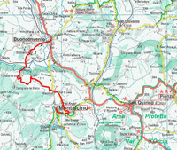
| Da Buonconvento a San Quirico per Montalcino Da Buonconvento a Montalcino | Montalcino - Abbazia di Sant’Antimo | Da Montalcino a San Quirico d'Orcia |
||||||||||
| The Via Francigena in the Siena Region |
||||||||||
| Between Montalcino and Torrenieri |
||||||||||
| Only the northeastern end of the territory of Montalcino was affected by the passage of the Via Francigena, corresponding more or less to a stretch of the Via Cassia prior to its recent rectification. We start from Montalcino and we take the road that leads to the Via Cassia, after 1.7 km turn Buonconvento, and reach the farm Cottimello, arichtettonico old complex dating to the Middle Ages. Continue for 4 km to the Cantina Sociale and turn right a little further we find the ancient complex of Collodi. Continue until you come to the Altesino estate. Little further we come to the Castle Altesi. From here we return to the road and arrived at the junction turn right onto the Cassia towards South Shortly after we find the Villa of Rondinella characterized by an original Art Nouveau architecture, we continue to reach Torrenieri Cassia, where you can ammmirare the parish church of S. Mary Magdalene, we return to Montalcino along the road, past the junction for Buonconvento turn right to visit the Church of the Observance, and then go back and get again Montalcino. The Art Nouveau in Buonconvento was anything but provincial, and evolved into a calm, elegant style, that played on materials, colors and decorative effects, on both exteriors and in the decoration of interiors dominated by floral patterns, well represented in the frescoes, stained glass and wrought iron work. On the Cassia, Villa Rondinella stands on a small hill. Designed by Gino Chierici (1910), it is richly decorated and built with fine materials.A rich floral iconography is represented both in the frescoes and in the windows and wrought ironwork, showing careful research into the use of different materials. Comune di Montalcino Itinerari | Montalcino-Podere Cottimello-Podere Collodi-Castello Altesi-Altesino-la Rondinella-Torrenieri-Chiesa dell'Osservanza-Montalcino (Italian) |
 Torrenieri |
|||||||||
| From Castelmuzio to Pienza |
||||||||||
| Solitary cypresses or lining in long rows ancient country roads, vineyeards which follow the ups and downs of rolling hills, streams overshadowed by trembling poplars, oaks and holm-oaks woods, strawberry trees and brooms growing on the banks of the roads, they make up the landscape which can be enjoyed on approaching Castelmuzio, the old, suggestive medieval village in the heart of Tuscany. |
||||||||||
La Via Francigena | From Siena to Ponte d'Arbia - 28.5 km Map | View Tappa 12 in a larger dimension |
||||||||||
 |
||||||||||
Montereggioni |
||||||||||
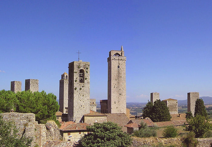
| From San Gimignano to Monteriggioni - 29,8 km | ||||||||||
Total length (km): 29.8 Travel time on foot (h: min): 7.30 Paved roads: 19% Dirt roads and driveways: 70% Mule tracks and trails: 12% Getting to the starting point: FS Empoli-Siena Railway Line, Poggibonsi station; bus line 133 for S. Gimignano View Tappa 10 in a larger dimension on Google Maps |
||||||||||
| This 29.8 km leg begins in San Gimignano and takes in about 7 hours to complete. It is one of the most beautiful legs of the Via Francigena, and after the frst section of the path, you begin to walk up and down in the valley of the Foci river, near Molino d'Aiano. A path leads upward to the Romanesque church of Santa Maria a Coneo. Then you cross the bridge on the hilltop to reach the Romanesque church of San Martino di Strove. Then you go to the Abbey of Island, before catching a sight of Monteriggioni, with its unmistakable ring of walls and towers that dominate the surrounding hills. From San Gimignano to Monteriggioni - 29,5 km Da San Gimignano a Monteriggioni - 29,5 km |
 Pieve di Santa Maria Assunta in Chianni |
|||||||||
| From Gambassi Terme to San Gimignano - 13,4 km |
||||||||||
| A short stage, however an interesting one for the beauty of the landscape along the Via Francigena. Exiting from the centre of Gambassi Termi, one goes towards the Luiano farm, passing through terrain cultivated with vineyards. Once past the farm, we encounter the bridge of the Madonna, on the Torrente dei Casciani which marks the confine between the provinces of Florence and Siena and the entrance to the municipality of San Gimignano. From here the route goes uphill past cultivated fields and beautiful cypresses until reaching Pancole, the site of a Marian sanctuary and a place for refilling water. The route involves going through the underground passage of the large religious structure. Shortly after, one can already glimpse the multi-towered profile of San Gimignano. But before reaching the town we encounter the charming Romanesque parish church of S. Maria a Cellole, completed in 1238, as recorded in an inscription to the side of the portal. From the church, passing the houses of Sferracavalli, one can take a brief detour to visit an Etruscan necropolis with well-preserved hypogeous room tombs that date between the 4th and 1st century BC. There is no rest point along the route.From Gambassi Terme to San Gimignano - 13,4 km Da Gambassi Terme a San Gimignano - 13,4 km |  |
|||||||||
| From Monteriggioni to Siena - 20,5 km |
||||||||||
| Departure: Monteriggioni, Piazza Roma Arrival: Siena, Piazza del Campo Getting to the starting point: FS Empoli-Siena Line, Castellina Scalo station |
 |
|||||||||
| This 20.5 km leg begins in Monteriggioni and takes in about 6 hours to complete. Leave Monteriggioni and walk along the road in the Sienese hills to the medieval village of Cerbaia. It runs through the woods up to the Castle of Chiocciola and the Castle of Villa, before descending down toward Pian del Lago. Then cross the Renai woods before arriving at Porta Camollia, the traditional Via Francigena entrance to Siena. In the city, walk down Banchi di Sopra and then up to the end of this leg in Piazza del Campo, the Duomo and then the hospital of Santa Maria della Scala. From Monteriggioni to Siena - 20,5 km Da Monteriggioni a Siena - 20,5 km |
||||||||||
Monteriggioni circular walk | Trekking nella Montagnola senese tra Monteriggioni e Badia a Isola | Anello Monteriggioni | Monteriggioni - Badia a Isola - Castel Petraia - Monte Maggio (Italian)
|
 |
|||||||||
| Val di Merse | The Hermitage of Montesiepi |
||||||||||
The abandoned Cistercian Abbey of San Galgano with the Montesiepi hermitage rise in the valley of the river Merse, between the medieval villages of Chiusdino and Monticiano. |
|
|||||||||
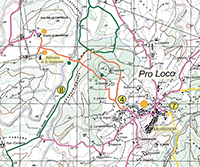
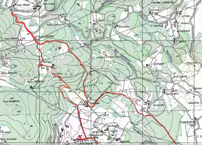
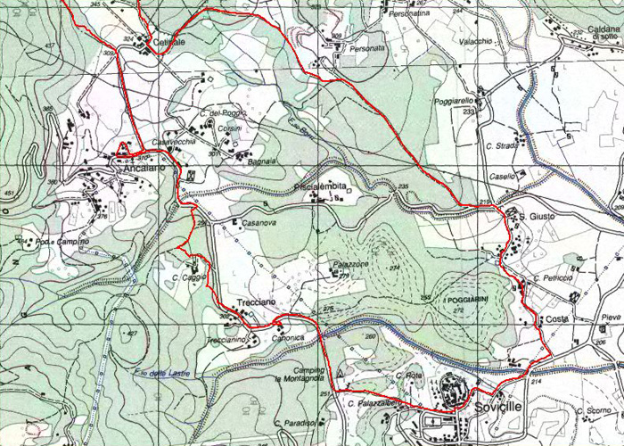
Val di Merse | Sovicille | Itinerarys in the surrounding hills of Sovicille |
||||||||||
Sovicille’s territory stretches from La Montagnola Senese to the valley of the river Merse. Anello Sovicille | Sovicille – San Giusto – Villa Cetinale – Il romitorio di Cetinale - Pieve di Pernina – Ancaiano – Villa Celsa - 16 km | Details (Italian)
|
|
|||||||||
 |
||||||||||
| The Val d'Elsa | The Val d'Elsa | |||||||||
| San Gimignano | San Gimignano |
|||||||||
| The municipality and the entire province of Siena offer an infinite variety of trekking and cycling itineraries. Paths and tracks which, in the case of the San Gimignano area, wind through valleys and hills, woodland and open country. On foot from San Gimignano you can reach Castelvecchio, the village of Lariano and the Romanesque parish church of Cèllole, the sanctuary of the Madonna di Pancole. There are many routes, on foot or by bicycle. Attempting a walk out of San Gimignano can be daunting, but the nearby countryside holds enough sites of interest to make it worth your while. Most trails depart from San Donato (downhill from the San Giovanni Gate) with routes taking you into the Castelvecchio Nature Reserve and the four kilometers to Pieve di Céllole, a pretty Romanesque parish church with a beautiful and quite surprising view back to San Gimignano. |
||||||||||
 |
||||||||||
|
||||||||||
|
||||||||||
|
||||||||||
 |
||||||||||
Trekking in the Crete Senesi, stunning landscape between Siena and Asciano |
||||||||||
|
||||||||||
|
||||||||||
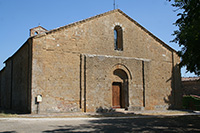
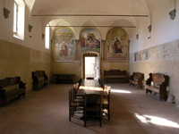
 Badia Ardenga
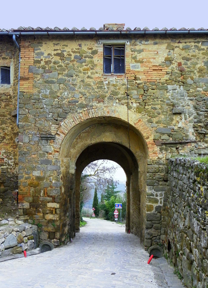
 L'eremo di Montesiepi (the Hermitage of Montesiepi)