Abbadia San Salvatore

Abbey of Sant'Antimo

Albarese

Acquapendente


anghiari

Archipelago Toscano


Arcidosso


Arezzo


Asciano


Badia di Coltibuono


Bagno Vignoni

Barberino Val d'Elsa

Beaches

Bolsena Lake


Bomarzo

Brunello di Montalcino

BuOnconvento

Campagnatico


Capalbio


Castel del Piano


Castelfiorentino

Castell'Azzara

Castellina in Chianti


Castelmuzio


Castelnuovo Bererdenga


Castiglioncello Bandini


Castiglione della Pescaia


Castiglione d'Orcia


Castiglion Fiorentino


Celleno


Certaldo


Chinaciano Terme


Chianti


Chiusi


Cinigiano


Città di Castello

CivitÀ di Bagnoregio


Colle Val d'Elsa


Cortona


Crete Senesi


Diaccia Botrona

Isola d'Elba

Firenze


Follonica


Gaiole in Chianti


Gavorrano

Gerfalco


Greve in Chianti


Grosseto


Lago Trasimeno


La Foce


Manciano


Maremma


Massa Marittima


Montagnola Senese


Montalcino


Monte Amiata


Monte Argentario

montecalvello

Montefalco


Montemassi


Montemerano


Monte Oliveto Maggiore


Montepulciano


Monteriggioni


Monticchiello


Monticiano


Orbetello


Orvieto


Paganico


Parco Naturale della Maremma


Perugia


Piancastagnaio


Pienza


Pisa


Pitigliano

Prato

Radda in Chianti


Roccalbegna


Roccastrada


San Bruzio


San Casciano dei Bagni


San Galgano


San Gimignano


San Giovanni d'Asso


San Quirico d'Orcia


Sansepolcro


Santa Fiora


Sant'Antimo


Sarteano


Saturnia


Scansano


Scarlino


Seggiano


Siena


Sinalunga


Sorano


Sovana


Sovicille

Talamone

Tarquinia


Tavernelle Val di Pesa


Torrita di Siena


Trequanda


Tuscania


Umbria


Val d'Elsa


Val di Merse


Val d'Orcia


Valle d'Ombrone


Vetulonia


Viterbo

Volterra


Walking in Tuscany
             
 
Amazing sunset in the Val d'Orcia, near San Quirico d'Orcia

Amazing sunset in the Val d'Orcia, near San Quirico d'Orcia [1]


Walking trails in Tuscany Surroundings


Walking in Tuscany | Val d'Orcia


The territory of the Val d'Orcia is made up, mainly of a hilly landscape with gently rolling hills and valleys typical of the Sienese Crete and a rich variety of vegetation. The river Orcia springs from a gorge and winds its way across the valley.
North west of Bagno Vignoni a magnificent rocky gorge covered with woodlands and Mediterranean maquis opens out onto the vineyards of Montalcino and then continues to the sea. On the slopes of Monte Amiata are forests of beech and chestnut trees and of particular interest and rare beauty is the holm oak woods of Scarceta. The Abetina del Vivo with ancient silver fir trees is situated near the old village of Vivo d'Orcia famous for its springs which provide water for much of the area.
the ancient roads of Val d’Orcia offer a great variety of itineraries. Wine lovers can go up to Montalcino through the Brunello vineyards. Those who prefer panoramic views can follow the ridge between Radicofani and Contignano, opposite Amiata. The pathway of the Orcia gorges offers Mediterranean atmospheres and flora.
The one that passes through the Orcia gorges from Bagno Vignoni leads to Ripa d’Orcia, a 20th century reconstruction of a fort that belonged to the Salimbeni and Piccolomini families. Ripa and its view of Amiata can also be reached from San Quirico by a dirt road that passes by the village and the tower of Vignoni. Going up from Castiglione d’Orcia to the Vivo you are immersed in the volcano forests. Between Monticchiello and Pienza, or around Sant’Anna in Camprena, you can enjoy the undulating outlines of hills that seem to pile up into infinity.

Bagno Vignoni - La Foce


Val d'Orcia | From the vineyards of Montalcino to the hills of Villa La Foce

 
This is a journey into harmony, down trails that seem to sail over ridges amidst cypresses, time-worn farmhouses and the geometric landscape. Wide-open spaces and unforgettable views accompany our ride through this worldly paradise up to Ghino di Tacco's stronghold. This unrivalledvantage point offers a breathtaking panorama over Terre di Siena, from Val d'Orcia to Monte Amiata and from the Crete to Monte Cetona.

 
Departure: the meeting of the Orcia and Asso waterways in the municipality of Montalcino
Arrival: La Foce - Municipality of Chianciano Terme
Distance: 28 km | Duration: about 5 hours

 
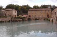
From San Quirico d'Orcia (the meeting of the Orcia and Asso waterways) to Bagno Vignoni | Distance 10,2 km |Duration: about 2 hours


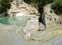
This itinerary starts from the point where the Orcia and Asso waterways meet and travels through the enchanting Parco Artistico e Naturale della Val d'Orcia. The starting point can easily be reached from San Quirico d'Orcia. From the valley we climb up through woods and geometric fields toward the Podere Santa Barbara and Podere Caggiolo farmhouses, with ever more evocative views over the Orcia valley at its narrowest point. We then reach the fine Castello di Ripa d'Orcia which contributed to the defence of the Sienese Republic from the second half of the 13th century onwards. In 1438 Ripa d'Orcia became a definitive part of Siena's holdings. The castle is undoubtedly worth a stop and consists of an impressive square tower surrounded by a circuit of irregularly-shaped walls with a single entrance. From here we briefly climb toward San Quirico d'Orcia, walk around Ripa d'Orcia's cemetery and then descend toward the Orcia river opposite Podere Le Mulina. We pass through an old travertine marble quarry and reach Bagno Vignoni, one of the most scenic hot spring resorts in Terre di Siena. In spite of all the battles, attacks and fires that Val d'Orcia witnessed during the Middle Ages, this village has remained largely unchanged. Bagno Vignoni boasts one of Italy's most unique town squares. In fact, this liquid square is actually an impressive Medieval swimming pool filled with bubbling water that exits the spring at a temperature of 52 degrees.
The vicinity of the bath to the Via Francigena, the pilgrims' route to Rome, persuaded the less-hurried travellers to make the acquaintance of the spa waters. On the edge of the small town there is a stone culvert where the hot water runs. You take off your shoes and put your feet in. After a long hike it is great. The water is very hot and full of minerals.


Bagno Vignini, hot springs

 
Bagno Vignoni - La Foce | Distance 16,5 km | Duration about 4 hours


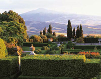
The characteristic of Bagno Vigoni, besides the thermal waters, is its unchanged structure. From Bagno Vignoni we go down to the Via Cassia (Strada Statale 2) to again reach the course of the Orcia river. We follow the trails along the river and cross the Tresa stream not far from the Castello di Spedaletto, an interesting fortified village important in Medieval times as a rest stop for pilgrims travelling to Rome. Now we travel down an open valley along the Orcia river until we near where it meets the Formone river. Wide-open spaces facilitate our ride to the farms of Poggio Meriggi, Torricelle, Casalta and Casanova. At this point we go down one of the most famous and photgraphed roads in the province of Siena, lined with cypresses that delineate its curves. We then reach the Strada Provinciale that links Monte Amiata to Cianciano Terme. We walk around a number of old farms (Sant'Antonio, Fonte al Gozzo, Fonte Tetta) and finally reach the Fattoria della Foce, a graceful Renaissance residence whose classic Italian garden and antique rose bushes may be visited on appointment. From here we easily reach Chianciano Terme and Val di Chiana.

The Castello di Spedaletto [Spedaletto Castle]
This magnificent Castle was built in the XII century along the ancient Via Francigena, which in the Middle Ages was the link between Rome and northern Italy. Like many other fortified structures in the province of Siena, the complex fell under the influence of the Spedale di Santa Maria della Scala as of the 13th century. The original square-plan structure with corner towers and projecting stone corbels, was fortified between the late 15th century and the early 16th century, with the addition of a slight escarpment and embrasures for the use of fire arms.

Gardens in Tuscany | Villa La Foce


Castello di Spedaletto


Villa La Foce

   
Bagno Vignoni - Bagno Vignoni | Distance 9 km | Duration about 3 hours


Bagni Vignoni derives its name from the 11th century castle that still towers over the village. The thermal baths are architecturally inviting with a porch-type bridge built over the water. This water is then transferred from the bath to the many thermal houses that line the village. The water then passes through mills located on the banks of the river.

All around there are some buildings realised by Bernardo Rossellino in Pope's Pio II honour, and the open arcade where S. Caterina da Siena stopped.

Castiglione d'Orcia marks the boundary between Val d'Orcia and the Monte Amiata forests. The Actual Castiglione, harvest to the feet of the mighty Fortress of the Aldobrandeschis, offers still its medieval aspect to the visitor with picturesque and characteristic angles. The walk through Castiglione should include a visit to the Romanesque Church of S. Mary and Magdalena, which have been recently restored. The bell tower is very interesting, too. Because of the number of works of art that it contains, the Church of Saints Steven and Degna was the most important religious building in Castiglione, even though its interior is not particularly interesting.


Bagno Vignoni boasts one of Italy's most unique town squares

Itinerary in the great scenery of the Val d’Orcia. The hike from Bagno Vignoni to Rocca d’Orcia is absolutely stunning. The crossing of the Val d'Orcia follows the old Via Cassia for some short stretches but then climbs up to Rocca d’Orcia in a landscape that becomes increasingly wild and solitary.

Trekking in Tuscany | Circular walk Bagno Vignoni, Vignoni, Ripa D’Orcia and Rocca d’Orcia | 17,5 km
Itinerary in the great scenery of the Val d’Orcia, between Bagno Vignoni, Vignoni, Ripa D’Orcia and Rocca d’Orcia


There is a good, shorter alternative, avoiding the climb to Ripa d'Orcia and Rocca d'Orcia, folllowing the Orcia river instead.

Circular walk | Anello Bagno Vignoni – Vignoni Alto Anello | 9 km, 3 hours


Castiglione d'Orcia - Castiglione d'Orcia


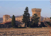
Situated in the middle of the Val D’Orcia, and above the river of the same name, the town is surrounded by a natural environment which has remained, on the whole, unchanged.
The most important religious building of Castiglione d' Orcia is the church la Chiesa dei Santi Stefano e Degna with its façade from the 1500's. At the highest point in town, one can still see remains of the original city wall which opens upon a view of the mountain Monte Amiata and upon the fortress Rocca a Tentennano. The fortresses' imposing tower, recently restored, may also be visited when the fortress is open to the public. While there on its summit, enjoy the breathtaking 360 degree panorama from Siena to Radicofani, from Montalcino to Pienza and Montepulciano, and from Monte Amiata to Monte Cetona. Moving along past the Rocca a Tentennano, one enters into the village below called Rocca d' Orcia. Here worth a visit are the churches, the Pieve di San Simone, the Chiesa della Madonna delle Grazie di Manno, and the little main town square holding a cistern said to date back to 1262. In the large area covered by the municipality, many other towns also deserve a mention: first there is Bagni San Filippo, a place known for its spa waters which gush out water at a temperature of 52 degrees centigrade and which have deposited immense calcium deposits in the nearby Fosso Bianco (or White Ditch). Then there is Campiglia d'Orcia, featuring an unusual historical centre spreading out like a fan beneath a rocky ridge and from which rises a fortress built in the year 973. Ripa d' Orcia, on the right side of the river, has one of the most evocative castles in the valley.
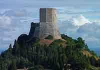
 

Rocca d'Orcia
Departure and Arrival: Castiglione d'Orcia
Length: 11.5 km
Road surface: dirt track and country road
Height difference: ca. 400 m
Duration: 3 hours on foot, 1 and a half hours by bicycle.


The itinerary starts on a downslope and ends uphill. From the hamlet of Castiglione d'Orcia we get to the bottom of the Orcia valley which is characterized by a wild environment where no means of transport are possible. It predominantly unfolds on dirt tracks. For the mountain bike enthusiasts it doesn't show any technical difficulties even though the downslope, specially in the first part, is very steep and the climbing back up is quite challenging.

We leave from the centre of Castiglione d'Orcia, and precisely from Il Vecchietta square, getting into Via del Cassero uphill to Porta di Sopra.
Once we're out of the village walls we climb down, on the right, toward the hamlet of Rocca d'Orcia. At the T junction, past the village, we turn left by the Tentennano rock. Past the San Simeone hotel we get onto the paved little road on the left which enters the centre of Rocca d'Orcia, in front of the little church of San Sebastiano and down to the Cisterna square.

From here we follow the road downhill to the stone arch out of the hamlet. Once we are at the church we turn left on the asphalted road and left again at the next junction (ca. 50 m). From here, the view over the Val d'Orcia and Pienza is very beautiful. At a hairpin we follow directions to Podere Colombaiolo and Podere Le Moline. The road, downhill, becomes a dirt track and climbs down to the bottom of the Orcia valley. We now go through olive groves and farming fields close to the Podere Colombaiolo and then proceed through the thick vegetation prevalently of oak trees. The cart road, marked with red and white paint, steeply climbs down offering a stunning view over the old village of Vignoni and Bagno Vignoni. We keep now following the main road avoiding all the left and right turns. After about 1 km the road, keeping at the same height, faces the opposite versant of the Val d'Orcia. From Rocca d'Orcia, after 2.5 km we arrive at the Podere Le Moline. The white country road goes between the farmhouse on the right and three cypress trees on the left. Instead of proceeding on the road, past the cypresses, we turn left into a trail that skirts the farmhouse's young vineyard. At the end of it the trail carries on the right entering the thick bush.

We walk now for a few minutes on the trail that, at a clearly visible hairpin, gets into a cart road which we will take on the right and downhill. After about 5 minutes we get to a junction where keeping the right we cross a small stream (dry in summer). We then go uphill to climb down again to another stream. Walking on the main trail we suggest to make a detour on the right to climb down to the wild valley floor where the river Orcia runs. From here we can enjoy a great view of the fortified hamlet of Ripa d'Orcia. We then climb back up on the same cart road for about 5 minutes.

After a little while we get to a clearly visible hairpin going uphill (avoid the right turn) and carry on walking following the red and white marks on the trail that goes up the valley's slope. The uphill footpath ends in the proximity of the ruins of the Montelaccio farmhouse. Here, past the ruins, we carry on straight ahead on the path that, in the open, runs midway up the slope passing by an old spring. After 800 metres we arrive at the Scalceta Farmhouse and soon after we turn left at the junction on the uphill track.

Beyond the hunting lodge called Il Leccino, next to an electric pole we turn left again and slightly uphill. After about 1 km we get to the Finocchieti farmhouse that overlooks the Mount Amiata on the side of Seggiano. Furher up the view also opens up on the left side (north) of the road over the hill of Montalcino. We proceed on the dirt road for about 1.5 km up to a junction where we turn left for the last part of the uphill slope toward Castiglione d'Orcia going through the most panoramic spot of the entire itinerary with great views over the Maremma, Amiata, the Cetona mountain and the Val d'Orcia. Back on the asphalted road we arrive at the highest spot of Castiglione d'Orcia from where we enjoy the view over the imposing Rocca of Tentennano. We enter the village through the Porta di Sopra which is very close to Piazza Il Vecchietta.
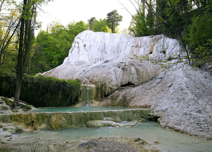


Bagno San Filippo
   
The province of Siena offers multiple choices for the lovers of vacations on bicycles; from Sunday riders to professionals, from road cyclists to mountain bikers, there is such an array to choose from that your head will spin.
Apart from the series of daily routes which are in effect loop rides, in other words they begin and end in the same place, there is the possibiliy of creating itinerant routes which travel across the Sienese territory: the Tour of the Land of Siena and the route of the Eroica ralley. The daily routes can be chosen based on several different criteria, the level of training one has, the type of route prefered, the topography of the zone and its roads and the type of cycle one has.
The two long routes, the Eorica and the Tour of the Land of Siena, offer the possibility of discovering the dimension of the slow trip along an ever changing countryside.


Tuscany | The Val d'Orcia


A walk through Montepulciano


Confined within its ancient city walls and bastions, Montepulciano is crossed by a long wide street called the Corso, the main street of Montepulciano. The Corso stretches for 11.5 kilometers from the Porta al Prato to the Piazza Grande at the top of the hill.
You can conveniently start exploring the town, from either one of its main gates: Porta al Prato or Porta delle Farine, where buses arriving from Siena and Florence stop. Outside the city walls below Porta al Prato, squats the church of Sant' Agnese, with a striped 1935 facade surrounding a 14th-century portal.
This is where our tour starts.
From the gate, walk southwards along Via di Gracciano nel Corso from which a series of alleys and narrow streets depart. Walking through the town streets bordered by XVI-century buildings, one can visit the baroque Church of S. Bernardo, Palazzo Batignani, Palazzo Tarugi, Palazzo Cecconi and Palazzo Buccelli, decorated with stone from Etruscan and Roman buildings. The Tower of Pulcinella and the theatre built in honour of the XVI-century poet Angelo Poliziano who was born here. The Cathedral of Santa Maria Assunta, or the Duomo of Montepulciano, includes a masterpiece from the Sienese School, a massive "Assumption of the Virgin" triptych painted by Taddeo di Bartolo in 1401.

The Sanctuary of the Madonna di San Biagio, outside the city was by Antonio da Sangallo the Younger between 1518 and 1545. It has a circular (central) plan with a large dome over a terrace and a squared tambour. The exterior, with two bell towers, is built in white travertine.


Walking in Tuscany | A walk through Montepulciano


Outside the Bucelli Palace is an unusual foundation made up of tombstone fragments of Etruscan and Roman art


Mappa Val d'Orcia | Ingrandire mappa


Walking in Tuscany | Val d'Orcia


An exellent selection of hiking trails can be found on the website of Podere Santa Pia.
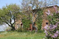
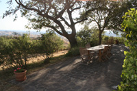
Walking in the Val d'Orcia | Itineraries | Percorsi di Trekking in Val d'Orcia


Holiday accomodation in Tuscany


Hidden secrets in Tuscany | Podere Santa Pia

         
Rocca di Tentennano
Podere Santa Pia
 
Podere Santa Pia
 
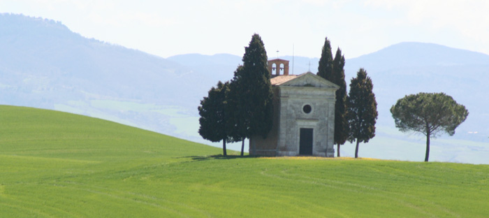
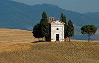
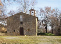
Madonna di Vitaleta Chapel, San Quirico d'Orcia
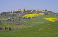
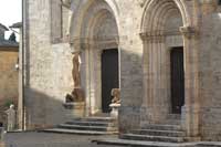


Pienza
Pieve di Santa Maria dello Spino
San Quirico d'Orcia


The landscape ot the Val d'Orcia as it unfolds nowadays was created by wealthy Siennese merchants in the 14th and 15th centuries. The farms cultivate mainly grains, vines and olives. Rows of cypresses are also a distinctive sight. The beauty of the area inspired Renaissance painters and early travellers on Via Francigena.

Pienza

It was in this Tuscan town that Renaissance town-planning concepts were first put into practice after Pope Pius II decided, in 1459, to transform the look of his birthplace. He chose the architect Bernardo Rossellino, who applied the principles of his mentor, Leon Battista Alberti. This new vision of urban space was realized in the superb square known as Piazza Pio II and the buildings around it: the Piccolomini Palace, the Borgia Palace and the cathedral with its pure Renaissance exterior and an interior in the late Gothic style of south German churches.
The historic centre of Pienza represents the first application of the Renaissance humanist concept of urban design, and as such occupies a seminal position in the development of the concept of the planned 'ideal town' that was to play a significant role in subsequent urban development in ltaly and beyond. The application of this principle in Pienza, and in particular in the group of buildings around the central square, resulted in a masterpiece of human creative genius.
The leading humanist Enea Silvio Piccolomini (1405-64), elected to the papal throne in 1458 as Pius II, was born in Corsignano, situated on a hill overlooking the Orcia and Asso valley a short distance south-east of Siena. When he returned there after becoming pope, he was struck by the extreme misery of its inhabitants, which inspired him to endow his birthplace with new buildings, and make it his summer court. His vision derived to a great extent from the German-born philosopher Cardinal Nicolà Cusano. The link with the German Gothic tradition is shown by Pienza Cathedral, which the pope wanted to be in the same style as the late Gothic Hallenkirchen in Germany. To transform Corsignano Pius II called upon Bernardo di Matteo Gamberelli, known as Rossellino, ingegnere di palazzo to Pope Nicholas V in Rome, where he had been influenced by Leon Battista Alberti, the humanist thinker and architect, responsible for the restoration of Rome in 1447-55 and author of De re aedificatoria (1452), the first architectural treatise of the Renaissance.
Rossellino was responsible for the major buildings around the central square, where work began in 1459. He was also responsible for the overall layout of the town, based on the principles of Renaissance town planning enunciated by Alberti. The walled village of Corsignano consisted of a main street joining the two gates, flanked by smaller perpendicular parallel streets. Rossellino largely respected this basic structure when siting his major buildings around the main square. Pius II's project also required the building of large houses for the cardinals in his retinue, and work on these began in 1463. Two structures with a social function, the hospital and the inn in front of the church of St Francis, were also built on his orders.

The ideal centre of Pienza is the Piazza Pio II. Its trapezoid plan is emphasized by the herringbone paving edged with travertine. On the south side of the square is the cathedral (built 1459-62), designed by Rossellino. The influence of Alberti is strong in the composition of the triple facade with its wide arches, corresponding with the three-aisled interior. The interior, divided by tall clustered pilasters from which the arches and cross-vaults spring, was inspired by the Hallenkirchen. The bell tower also blends Gothic and Renaissance forms. On the west side of the Piazza is the Piccolomini Palace, built in 1463 on the site of old houses owned by the family. The front elevations, resting on a travertine plinth, are divided into three bands of sandstone ashlars, interrupted by wide arched windows. Three of the sides are the same and the fourth, with an imposing triple-tiered Ioggia, looks out on a raised garden. The fine interior courtyard is decorated with sgraffito ornamentation on the second and third floors.
The Episcopal Palace is on the opposite side of the piazza. The old Pretorio Palace was purchased in 1463 for Cardinal Rodrigo Borgia, who added an extra storey and replaced the Gothic windows. The Town Hall (1462) on the north side of the square is in conventional Tuscan style for buildings with this function, with an open loggia at ground level and a crenellated tower. In contrast with the other buildings around the square, it is in stuccoed tufa and brick, decorated with sgraffito, only the loggia in travertine.
The other major buildings in Pienza line the Corso Rossellino, most built as houses members of the papal court, although some earlier buildings survive. They include the Gothic Church of St Francis and its Convent; the Atrebatense Palace (Gothic structure with Renaissance decoration); the Ammannati Palace, in Renaissance style; the brick Palazzetto; and the Gonzaga Palace, one of the few buildings that retains its garden. Pienza has many Renaissance fountains and wells, the designed by Rossellino.
[from Historic Centre of the City of Pienza | whc.unesco.org]

The Pieve di Santa Maria dello Spino, between Monticchiello and Bagno Vignoni, is used on the annual Corpus Domini procession, the Processione del Corpus Domini.
Tuscany | Small parish churches or pievi in Tuscany

Montepulciano is the largest Comune in the Sienese Valdichiana and contains six other villages: Abbadia di Montepulciano, Acquaviva, Gracciano, Montepulciano Stazione, S.Albino and Valiano. The poet Agnolo Ambrogini (known as "il Poliziano" from the Latin "mons Politianus") was born here. The town is said to have been founded by the Etruscan king Porsenna and exhibits impressive architecture, mainly but not only Renaissance. Michelozzo, Baldassarre Peruzzi and Vignola all worked here, as did Antonio da Sangallo il Vecchio who designed the temple of San Biagio. Apart from the wonders of the historical centre of Montepulciano the tourist would do well to visit the spa centre at S.Albino. The local economy is based on agriculture and the town is famous for its Vino Nobile. In th summer the town hosts the "Cantiere Internazionale d'arte" and in the mid-Augut holidays the "Bruscello", a traditional show spoken in rhyme, is performed on the Cathedral steps. On August 29 a wine barrel race, the "Bravìo", is run between the different contrade, or districts, of the town and there is a procession in 13th-century dress.


[1] Photo by Antonio Cinotti, published under a Attribution-NonCommercial-NoDerivs 2.0 Generic (CC BY-NC-ND 2.0) license.

[2] Photo by Bouncey2k