
 |
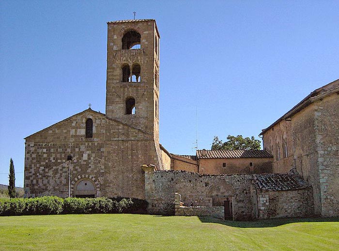
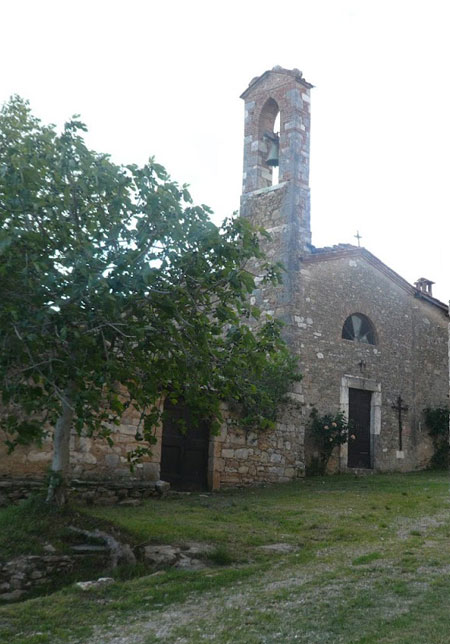
Sovicille, Pieve di San Giovanni Battista a Ponte allo Spino |
Sovicille |
Sovicille is located in the Val di Merse, an area of lush forest and mediaeval villages, and has played a remarkable role in the history of Republic of Siena. The village is located about 10 km west of Siena on the old via Maremmana, the road running from Sienna to the coast of the Maremma. Tuscan hidden treasures | Sovicille
|
|||
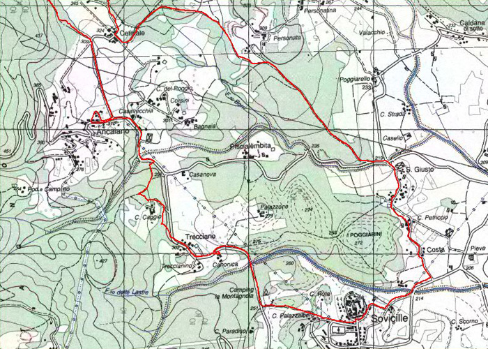
| Itineraries in the surrounding hills of Sovicille |
|||
 |
|||
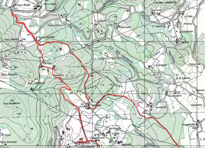
| La montagnola senese extends in the districts of Siena, Monteriggioni, Sovicille and Casole d'Elsa, but for the most part it is located in the district of Sovicille. During the XII-XIII century several churches were built, among which the parish church of Pernina, Molli, S.Giusto a Valli, San Lorenzo martire, S.Maria di Ponte allo Spino, the parish church of Rosia and San Lorenzo martire. In the same period some towers (Palazzone di Sovicille and Palazzaccio di Toiano), castles (Celsa, Montarrenti, Cerreto Selva e Palazzo al Piano) were built, too. Several ancient villages and churches are really charming; among the first ones there is the XII century white fortress of Monteriggioni, with its boundary wall reinforced with 14 square towers. Among the second ones: the wonderful parish churches of Radicondoli, Ponte allo Spino in Sovicille, San Giovanni in Rosia, the Augustinian hermitage of Lecceto, and finally the original complex of Abbadia Isola, a medieval village built in 1001 around the Cistercian Abbey of San Salvatore. Sovicille’s territory stretches from La Montagnola Senese to the valley of the river Merse. Most of the itineraries around Sovicille are covered by the Carta Turistica (Turistic Maps) and by the Sentieri della Montagnola Senese 1:25000 (The Sienese Montagnola Paths) Club Alpino Italiano (CAI: Italian Alpine Club) Sezione di Siena (Multigraphic Edizioni, Firenze). Anello Sovicille | Sovicille – San Giusto – Villa Cetinale – Il romitorio di Cetinale - Pieve di Pernina – Ancaiano – Villa Celsa - 16 km (Italian) Anello Monteriggioni | Monteriggioni - Castel Petraia - Monte Maggio |
|
||
| Itinerary 1 | Cennina, Casa Luciano, Castello di Celsa, podere Bareto, La Cetina, podere Morra, podere Chiostro, podere Gabbreta, Pernina, Romitorio, Cerbaia, Campo di Pania, Cennina | 12 km | 3h 30' It is a short distance from Villa Cennina to the paved road which we turn right on to. Proceeding along a slight slope in the woods we reach, after about 1600 mt., Casa Luciano (Luciano House) (you can arrive up to this point in a car). You proceed along the paved road for about another 1500 mt. until you reach a flat open space (meadow) from which it is possible to admire, on your right, the Castello di (castle of) Celsa. After about another 1500 mt., in correspondence to a small stone construction, you leave the asphalt turning left on to a dirt road (white/red CAI indicator N° 110). The road, initially on a false plain, after about 300 mt. in correspondence to the Podere Bareto (Bareto farm) (on the left), starts to climb steeply and has various curves. After about 700 mt. at the top of the hill, you reach a crossroads (from which it is possible with a brief detour to your right of about 1000 mt., to arrive in the small hamlet of La Cetina, CAI indicator N°111). Proceeding to your left – CAI indicator N°110/111), passing the Podere Morra (Morra farm), after about 400 mt., you leave the dirt road to take a cart road on your left marked by a CAI indicator N° 110. At first you proceed on level ground, passing the Podere Chiostro (Cloister farm)on your left and after about 1000 mt., going up and down hills, you reach the Podere Gabbreta (Gabbreta farm). Following along a rough path, after about 300 mt., you come out of the woods reaching an open space (meadow) in which the church of Pernina is found. You follow the indicator 110 that is on the left hand side of the church and then, crossing a field, you reach a small cemetery. Here the path turns sharp right following the edge of the woods until it goes beyond a stone wall (attention for those on bicycle), and runs into a cart road which you take on your left so that you will soon arrive at the Romitorio which is about 500 mt. from Pernina. From here you can admire a splendid panorama of the Cetinale Villa below. Going down hill from here along the cart road you reach, after about 800 mt. and having passed an arch with a chain, the Podere Cerbaia (Cerbaia farm). You turn to your left on the dirt road and climb up (CAI indicator N° 109/110) along a cart road with a sign which reads Campo di Pania (Pania’s field) (CAI indicator N°109) with up and down hilly ground. After about 800 mt. you reach the paved road described at the beginning near the Casa Luciano (Luciano House) which you can quickly reach by turning left for those who have left their car there). Turning right on to the paved road and going in the opposite direction to what is described at the beginning, you arrive at Villa Cennina after about 1800 mt. |
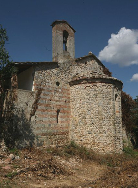
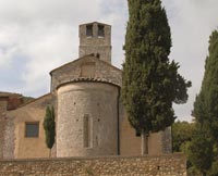 Pieve di Pernina Pieve di Pernina |
||
| Itinerary 2 | Cetinale, Tebaide, Romitorio, Pernina, Ancaiano, Cetinale | 9,5 km | 3 h You set off in front of the entrance of Villa Cetinale and you cross the hamlet in the direction of Celsa. After having gone along the villa’s wall on the left, you find on your right the arch which leades you to Tebaide (gate). On your left you follow the CAI indicator N°110 and in 300 mt. you arrive in front of a house. From there starts a little path in the woods which is closed with a chain. You go up hill for about 900 mt. until you reach the Romitorio from where you can admire a splendid panorama. Passing the building continue for 150 mt. on a cart road. Then you turn right on a path which arrives at the church of Pernina. Behind the bell tower of the church of Pernina you turn left following the CAI indicator N°110. You go past a small field and enter the woods. The cart road goes up hill and after 300 mt. you find an abandoned farm house, Gabbreta. You cross it and on a flat cart road you arrive at the Chiostro farm house. You turn left on a carriage road following the CAI indicator N° 111 and in 1600 mt. you arrive at the Incrociati farm where you find the paved road that goes from Ancaiano to Pievescola. |
 Villa di Cetinale Villa di Cetinale |
||
| Itinerary 3 | Simignano, Fonte a Radi, Palazzo al Piano, Poggioli, Molli, Simignano | 9,5 km | 3h 10' |
|||
| Simignano is situated on a plateau 410 mt. high on the western part of the Sienese Montagnola, along the road that goes from Ancaiano to Pievescola. From the hamlet of Simignano you take the flat cart road, marked with the white/red CAI indicator N°115, which turns after about 100 mt. to the left and then, after about 300 mt., to the right. You go up the hill in the middle of a chestnut wood for about 600 mt. come to a crossing, where you find the indicator CAI N°114. You leave it on the right, to reach after 200 mt., another wide crossing. Do not take any notice of the path on your left, and following the indicator N° 115, go down hill for about 900 mt. until you reach a dirt road in the valley. Go left proceeding on flat ground for about 900 mt. until you reach a small stone construction: Fontarradi. Past it you leave the road to follow a steep path (still following the indicator N° 115) which climbs up in the middle of thick woods, until you reach after about 700 mt., an open field where the castle of Palazzo al Piano (the Palace on the Plain) is situated. From here you have a beautiful view of the small hamlet Radi di Montagna, situated on a hill on the other side of the valley. You proceed now to your left on a dirt road (CAI indicator N° 116) on a clearing in the woods for about 1300 mt. until you reach a crossing. Now leave the dirt road and turn left on a cart road (still CAI indicator N°116). You reach Podere Poggioli (Poggioli farm) and after 800 mt. you reach another crossroads. Turning to your left you keep on the N° 116 and you reach, after about 600 mt. of flat, level road, a wide crossroads, near a fountain with beautiful water lilies (Pescina a Molli – Molli’s Pool). You follow straight ahead according to the CAI indicator N° 117 for about 400 mt. After a brief climb to the ruins of a rural construction, you turn left following CAI indicator N°114 to quickly reach an field where the Pieve di Molli – parish church of Molli is situated. From here you go on, reaching, in about 200 mt., a small cemetery which you go around to the right. You climb over a small wooden gate and you enter the woods again where, on the edge of a marble cave, you can admire a chestnut tree of exceptional dimensions. You follow along the cart road marked with the CAI indicator N° 114, ignoring several paths on the left and on the right, for about 1400 mt. until you reach a wide crossing where you find the CAI indicator N° 115 again, which you found at the beginning of your itinerary and along which, proceeding inversely, you find Simignano after about 1200 mt. |
|||
Itinerary 4 | Campeggio, Palazzone, Piscialembita, Personata, Personatina, Poggiarello, San Giusto, Petriccio, La Costa, Sovicille, Palazzalbero, Campeggio | 9 km | 3 h |
|||
| From the Campeggio (Camp Site) “La Montagnola” you take the paved road on your right in the direction of Ancaiano. After a short distance which is rather flat, the road proceeds up hill coming out of the woods, with a beautiful view of the Torre di Palazzone (Big Palace Tower) on your right and following along the rectory of Trecciano on your left, you reach, after about 900 mt., the farm house of Trecciano. You continue on rather flat ground, along the edge of woods and within sight of vineyards for another 700 mt., to turn then to your right (sign for Siena). The road, after a beautiful view of the Villa di Cetinale on your left, enters the woods and after about 700 mt. you reach the hamlet of Pescialembita. You follow down hill along the paved road for about 600 mt., and after having passed over a bridge, you leave the paved road to take a path on your left which goes up hill into the woods. After about 200 mt. you enter a dirt road to your left which you follow uphill. Ignoring a deviation on your right, you proceed for about 1 km. and you reach a field and the small hamlet of Personata. Going around the inhabitated area on your right you enter the woods again following the white/red CAI indicator N° 121. Ignoring a deviation to your right and then another to your left, you arrive after about 500 mt. in the small hamlet of Personatina. Going down hill, you go around the inhabited area to your right and after about 100 mt. you encounter a dirt road which you take to your right for about 800 mt. until you reach the castle of Poggiarello. You turn right on the paved road (CAI indicator N°122) and you proceed on level ground until you reach a crossroads (about 700 mt.). You keep going straight up a steep hill which skirts the Pieve di San Giusto a Balli – Parish Church of St. Justine in Balli, on the left to arrive after 300 mt. in the hamlet of San Giusto. Still following the indicator N° 122, you arrive after about 200 mt., in the hamlet of Petriccio and after another 500 mt., after having ignored the indication for La Costa, you get onto the paved road that goes to Sovicille. You proceed to the right for about 200 mt., then having passed the hamlet of Canille, beyond the bridge, you leave the paved road and you proceed on the dirt road that in about 200 mt. will take you to the podere Casanova. Here you ignore the deviation to your right and you proceed straight on (road closed to traffic) skirting a wall that will take you to Sovicille after about 300 mt. You turn right on to the main road but then you immediately leave it taking on the left the road that goes down to the sports ground, and you go around the grounds on the right. At the end of this you get on to the path CAI N°114 which in about 700 mt. will take you to the Campeggio from where you started your itinerary. |
 La pieve di San Giusto a Bali |
||
| Itinerary 5 | Tegoia, Molli, Pescina a Molli, podere Colombaio, Cerbaia, Poggiarello, Casaotti Tegoia | 6 km | 2h From Tegoia we enter a beautiful chestnut wood along a dirt road marked by the white/red CAI indicator N°114. After about 1500 mt. on a slope near a field, we reach Pieve di Molli – the parish church of Molli. Having gone around on the right the ruins of a rural construction, we leave the indicator N°114 which goes up to the Pieve to follow to the left the indicator CAI N° 117 which after 400 mt. will take us to a crossroads near a fountain with beautiful water lilies (Pescina a Molli – Molli’s Pool). We take the cart road on the left, indicated with the number 117 to go down into the woods until you reach a crossroads with a dirt road about 1000 mt further on near the Colombaio farm. (Turning to your right going down 1000 mt. we reach the beautiful farm of Cerbaia). Our itinerary continues by turning left and reaching, after about 500 mt., the Podere Poggiarello – Poggiarello farm. Having gone around the farm, the road goes up and then on level ground you reach the paved road after about 1 km. You take the asphalted road to your left proceeding uphill and ignoring on your right the path N° 114, and the road for Casaotti. We are back in Tegoia after about 500 mt. |
|||
| Itinerary 6 | Borgo Pretale, Tonni, Cave del Baulino, Montarrenti, Eremo di Santa Lucia, Ponte della Pia, Le Reniere, Borgo Pretale | 9,5 km | 3h |
|||
| From Borgo Pretale you go right following the CAI indicator N° 118 and you reach a large crossroads. You keep to the left following the itinerary 117 and after a few meters we find the paved road and very shortly, still on your left, we are in the square of the hamlet of Tonni. We continue along the path N° 117 which from the square enters into the woods (marked on the last house of the hamlet). The nice road in the woods arrives at the marble quarry in the beautiful panoramic point of Montarrenti. From there, along a steep incline, we arrive at the SP73 (Provincial road 73) and right in front there are the indications for the Eremo di Santa Lucia –St. Lucy’s Hermitage. After a few meters we cross the Rosia Stream and on an antique road we arrive after 1,500 mt. at Ponte della Pia – Pia’s Bridge. The deviation to the Santa Lucy’s Hermitage is recommended (200 mt. on the right of the path). From the Ponte della Pia on the paved road (SP 73) we arrive after 1,600 mt. on an unlevel cart road on the left (CAI indicator 118) which goes up the steep hill with numerous curves until you reach Il Poggio le Piagge. In 1800 mt. the uphill climb ends and having passed the crossroads for Meletro on the left, the path becomes level at first, reaching the farms Le Reniere and then Borgo Pretale from which we started our itinerary. |
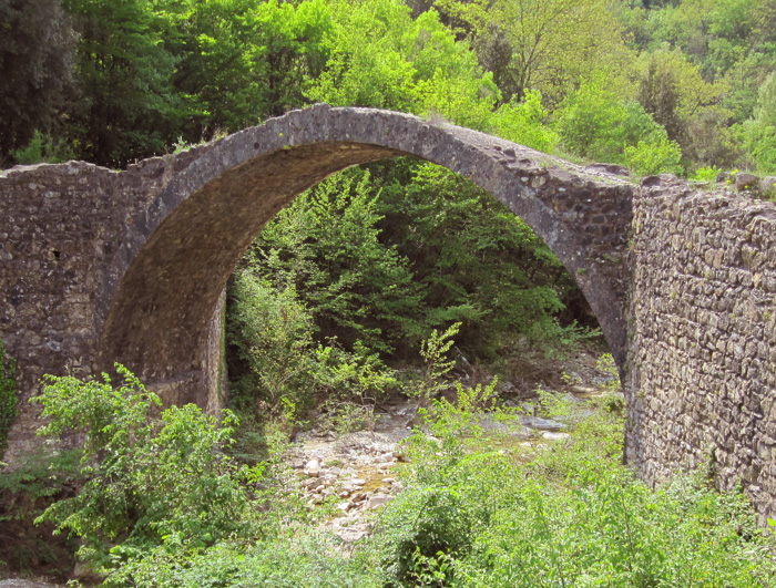
 Ponte della Pia |
||
| Itinerary 7 | Borgo Pretale, Le Reniere, Poggio Crocino, Poggio della Pigna, Poggiarello, Cerbaia, Borgo Pretale | 9,8 km | 3h |
|||
| From Borgo Pretale on the carriage road in direction of Le Reniere (CAI indicator 118) you enter the farm following the indications for the path N° 118 bis which begins with a small path up a steep hill that becomes an uphill road until you reach Poggio Crocino. You turn left following the main road and ignoring the indicators N° 119 so that you arrive in about 1000 mt. at the acqueduct, where, at the enclosure fence you turn left following a beautiful dirt road which in 1400 mt. will take you to the paved road that comes from Sovicille.You turn left following the paved road going up hill and after about 800 mt. you find the crossroads for Tonni . You turn left (direction for Tonni) following the dirt road (CAI indicator N° 117) which after 3500 mt. will bring you to the crossroads for Le Reniere. You turn left for Le Reniere and after 600 mt. on the path N° 118 you are back at Borgo Pretale. |
|||
| Itinerary 8 | Rosia, Ponte della Pia, Eremo di Santa Lucia, Castello di Spannocchia, Monte Acuto, Torri, Rosia | 10,5 km | 3h 30' |
|||
| Starting from Rosia you take the SP 73 (Provincial road 73) in the direction of Roccastrada and after 2 km. on paved road you arrive at Ponte della Pia – Pia’s Bridge, which you can easily see on your left. You cross the bridge keeping to your right along the cart road which is partly stone flagged and is the antique road to the Maremma region to the west. After about 700 mt. you arrive at a crossroads and you turn to your left (following the indications of a small marker: S. Lucia (St. Lucy’s) The road goes up for about 200 mt. until it arrives in front of the antique Eremo di Santa Lucia –St. Lucy’s Hermitage. We leave the building on our left following a path (difficult to be seen in the summer due to the rich vegetation) which takes us behind the hermitage. From there you follow the indications for Spannocchia (path 406 bis). The path takes us, in 1100 mt., to the castle. The first 600 mt. are steep, then the path becomes level until we find a crossroads which is well marked (406bis – Spannocchia) where we keep to our right. Shortly after the castle on the right there is a beautiful panoramic point: Le Rocce – the Rocks (marked). From Spannocchia we follow the larger dirt road leaving the castle on our right and after 400 mt., having passed a hairpin curve on our right, we leave the carriage road to turn left taking a steep cart road. Following the indications (path n.406), after 600 mt., the cart road becomes a level path and in 600 mt. you arrive at Crocino ( crossroads of 4 roads) You turn left on the carriage road (visible white/red signs on the trees) after 1200 mt. on the left of the carriage road, we find a hut which is a nice place for a picnic. You follow the same road and in 1400 mt. of steep down hill (splendid panoramas of the Rosia plain) you arrive in the hamlet of Torri. Having crossed the town center in 2 km. you go down the paved road and turning left onto the main road you arrive in the town of Rosia. |
|||
| Itinerary 9 | Brenna, Cimitero, Campalfi, La Steccaia, Torrente Ricausa, Mulino, Castiglion che Dio sol sa, Le Sugherelle, Lago di Stigliano, Montestigliano, Brenna | 12 km | 4h |
|||
| Leaving Brenna from the parking lot of the restaurant, you take path N° 402 and you leave behind on your right, after 400 mt. the small church and the cemetery. You enter in the Riserva Alto Merso (High Merse Reserve) where a path begins that skirts the mill channel (artificial deviation of the Merse River that goes back to the Middle Ages and was built to bring water to the mills of the area). At the end of the small path you turn left to arrive at Podere Campalfi (Campalfi farm). You cross the fields in front of the farm following the indications to go back into the woods at the end of the fields. At this point you start walking along a path in the middle of the woods. After a bit, the path starts to skirt the Merse River until it meets the Ricausa ditch. There you turn right to go up along it. As you walk along the stream you’ll find an old Mill in ruins, and from here with a short deviation to the left, after the mill, you reach in 50 mt. a small characteristic waterfall. You go back to the Mill and take the path to your left that goes up towards Castiglion che Dio sol sa. From Castiglion che Dio sol sa, on the road after about 600 mt., you arrive at the junction with the cart road that comes from Spannocchia. We turn right where the path N°405 starts which continues for 200 mt. on a cart road and then on a path (beautiful panoramic view at the highest point) to arrive at the carriage road that goes down to Poggio di Siena Vecchia (Hill of Old Siena) You follow the road until you reach, going down hill, the road that connects Stigliano to Podere Campalfi. You turn left in the direction of Stigliano for 50 meters, then you leave it to turn to your right in the woods that go up for about 600 mt. to the “Avenues” of Stigliano (beautiful roads with cypress trees) where you turn right going down the whole avenue at the end of which you find some fields. You turn right following another “avenue” with holm-oak trees, at the end of which you’ll find the Podere Montestigliano (Montestigliano farm). Here the path N°405 starts and finally arrives above the hamlet of Brenna (beautiful panoramic view). In 500 mt. you are back to where you started from. |
|||
| Itinerary 10 | Toiano, Palazzaccio, Valli, Caldana, Valacchio, La Casella, Campora, Cennina, Pastine, Toiano | 11 km | 3h 30' |
|||
| You leave the hamlet of Toiano going north on the paved road and having ignored the deviation on your left for Ponte allo Spino, you proceed straight on (white/red CAI indicator N° 123/125) reaching, after about 300 meters, the small hamlet of Valli. Having come out of the inhabited area, you proceed on the paved road (ignoring the indicators in succession n°125, 123 and 122) until you reach, after about 700 mt., the hamlet of Caldana. (You can obtain fresh water here). Having passed the houses after about 300 meters, you turn right so as to enter into the hamlet of Valacchio. Having gone through the hamlet, you proceed on flat land on a cart road for about 700 meters until you reach the indicator CAI n°121, in sight of the Podere Casella (Casella Farm) Here you can find a riding scholl. You turn left and you go uphill for 100 mt. until you reach a farm house where the road forks. You follow the white/red signs on your right and go uphill so that you reach, in about 200 mt., the hamlet of Personatina. Having left the inhabited area behind you and having ignored a deviation on your left, you continue following the indicator n° 121 that enters into the woods. Having done 200 mt. you turn right and you continue on, at first on level ground, then down hill and then uphill, to reach, in about 700 mt., and with numerous curves, the Podere Campora (Campora Farm). You go beyond it and uphill, and after about 1200 mt., you reach a paved road near the Podere Montauto (Montauto Farm). You go right down hill and proceed along the paved road for about 2500 mt. until you reach the crossroads, having passed a bridge, the dirt road on flat land marked with the indicator CAI n°122 which you take on your right. Having passed about 200 mt. you turn right again. Having passed another 400 mt. you leave the CAI indicator n°122 to enter, on your right a path that is not very smooth that goes along the edge of a wood in sight of cultivated fields. You go on until you reach the indicator n° 122 again after about 1000 mt. which you take on your right to reach after about 500 mt. the Podere Ripostena. Having ignored on your right the indicator CAI n° 121, you proceed according to the indicator n° 122 which in about 1000 mt. will take you back to Caldana. From here you go inversely along the itinerary described above until you reach the hamlet of Toiano after about 1000 mt. |
|||
| Itinerary 11 | Linari, podere la Corte, Poggio Salvi, Staffoli, Turamino, Viteccio, Chiesa di Barontoli, podere Agresto, Linari | 4 km | 1h 30' |
|||
| The 18th century Villa Linari, or San Lorenzo a Linari, is a medieval monastery located in the wonderful Montagnola area 8 km southwest of Siena. Built in the XIth century, it was converted to a grand country 500 years later by renowned Sienese architect Baldassarre Peruzzi. Linari is close to the village of Barontoli and was therefore ideally located to accomodate foreign wayfayers. Linari was the headquarters for a strategic event in the bitter clash between Pope Gregorio IX and Emperor Frederico II. Noble families such as Bolgherini and Bandini-Piccolomini made their homes here, and Giovanni Antonio Bazzi (known as Sodoma) painted an altar piece here, (sadly this has now been lost as with so many antiquities). Sodoma also influenced the structure of the building with architect Baldassarre Peruzzi, who brought the Villa back to life. His style is clearly visible in the airy porticoes and the use of the colour burnt sienna. From Linari you leave the deviation on your left for the Podere Corte (which you can reach going back a little), and you proceed along the uphill paved road for about 500 mt. until you find a crossroads. You turn left and again to your left shortly after following the indications for the hamlet of Poggio Salvi which you reach in about 300 mt. You return going in the opposite direction until you reach the crossroads previously described and you go right slightly uphill skirting the Podere Staffoli ignoring on your left the dirt road that will take you to Villa Viteccio which is private property. You pass the Podere Turamino and finally reach after about 1500 mt. the acqueduct tower of Barontoli. In front of the tower you turn right down hill along a dirt road and ignoring a deviation to your right, you shortly reach (after about 300 mt.) the church of Barontoli. Having done another 200 mt. you reach a farm house which you go around on your right into a field. You go beyond this reaching the border of the woods which you go along for about 100 mt. and then you turn left and immediately to your right getting on to an enclosed path within the woods. You keep going down hill (south west direction) along a path that rapidly comes out of the woods and goes in the middle of cultivated fields until you reach after about 500 mt. a second path in the middle of the fields. You turn right and proceed on flat ground until you reach Linari in about 700 mt. |
|||
| Itinerary 12 | Castello di San Rocco, Brucciano, podere Il Moro, rientro nella strada del Luco, San Domenico, San Felice, San Francesco, fosso Serpenna per 1 Km. fino a Casalta, Villa Cavaglioni, Castello di San Rocco | 12,7 km | 3h |
|||
| From the Castello di San Rocco you take the paved road on flat ground in the direction of the town of San Rocco a Pilli. We leave this road after about 500 mt. turning right following the indicator for Brucciano. Having done about 1300 mt. and having passed the hamlet of Brucciano, the road becomes a dirt road and you start going down through cultivated fields.You follow this road for about 3200 mt. until you reach a crossroads with the Siena – Grosseto highway. You cross this and go in the direction of Orgia and after about 600 mt., leaving the Molino del Palazzo a Merse (the Merse Palace Mill), you turn right on a dirt road which you follow for about 2500 mt. until you reach a crossroads where you go right following the paved road. You go down this for about 3700 mt. passing the farms of San Domenico, San Felici and San Francesco. Having crossed the Fosso Serpenna and skirting the Podere Casalta, you finally reach the Cavaglioni Villa . Here you meet the paved road again. You turn right and after about 900 mt. you are back to where you started from. |
|||
| Museo del Bosco di Orgia Located in an old barn, it houses all the testimony of man’s close relationship with his environment. The museum includes five walking itineraries: the Charcoal Burners (4 kilometres); the Hermitage (5 kilometres); the River (4 km), and Castiglion che Dio sol Sa (21 kilometres). These are pleasant, interesting excursions ranging through anthropology, botany, fauna and landscape and will provide you with dynamic knowledge of the woods and related activities. The theme excursions are also of interest. The wood as laboratory consists of an excursion along one of the itineraries with a more in-depth approach to determined aspects of botany, fauna, geology and ecolog Itinerary 13 | Orgia, Itinerari del Museo del Bosco: La passeggiata del Conte, Il fiume, il Romitorio, le carbonaie | 1,5 km | 40' |
|||
|
|||
| Itinerary 14 | Sovicille, Palazzavelli, Tombe etrusche del Luco, Malignano, Padule, Aeroporto, Ampugnano, La Sala, Pieve del Ponte allo Spino, Sovicille | 11 km | 2h |
|||
| From Sovicille you go in direction of Rosia and 500 mt. outside of the town you find a small chapel. On the right hand side of this there is a path that leads in about 600 mt. to the hamlet of Palazzavelli which you cross in direction of the paved road. But after about 50 mt. you turn right on to a dirt road. You follow this straight ahead ignoring the deviations to your left and skirting the woods that you have to your right, you arrive in about 1500 mt. at the Etruscan Tombs of Luco. You turn left on to the SP 73 (Provincial Road 73) and after about 600 mt. you reach Malignano. Here you turn right in direction of Padule on to a dirt road that you follow for about 2200 mt until you reach the Airport. You turn left on to a road with a bar across the road that skirts the airport on your right and after about 2400 mt. you arrive at a crossroads where you turn left leaving to your right the hamlet of Ampugnano. Going down hill you arrive at the crossroads with SP 73 that you cross taking the road that leads back to Sovicille, skirting the farms La Sala and La Macchia. After about 1500 meters, at another junction, you find on your right the Pieve di Ponte allo Spino which you can reach with a deviation of 100 mt. You then return back taking the paved road in direction of Sovicille which you reach in about 1400 mt. |
 Sovicille, Pieve di San Giovanni Battista |
||
| Itinerary 15 | Cycling Itinerary | 39 km | 3h | Sovicille, Rosia, Montarrenti, Tonni, Tegoia, Molli, Incrociati, La Cetina, Celsa, Pernina, Romitorio, Cetinale, Piscialembita, Ponte allo Spino, Sovicille Leaving Sovicille, and following the SP37 (Provincial Road 37) in direction of Rosia, you arrive after the hamlet of Malignano at the Etruscan Necopolis of Luco. Continuing along the SP73 (Provincial road N° 73) you go through the small town of Rosia. Going along the paved road in a narrow gorge you pass by on your left the Ponte della Pia. Continuing along this road you arrive at the Colonna di Montarrenti (an old stone column boundary sign in the middle of a junction) near which is the old castle on the right which gives it its name. From there we turn right going down hill in the direction of Colle di Val d’Elsa on to the SS 541 (state road 541) and after 1 km. we take the road on our right for the small medieval hamlet of Tonni. |
 Il romitorio di Cetinale |
||
| Itinerary 16 | Cycling Itinerary | Torri, Stigliano, Viali, Montestigliano, Orgia, Merse, Brenna, Stigliano, Torri | 18 km | 2h |
|||
| Leaving Torri, immediately outside the arched door, you go up on your left and you face a hill of 300 mt. that is a bit difficult. After, in fact, you go through nice up and down hills, but you must be careful with your hands on the brakes. Having ridden for about 1 km. you go up a path that opens on the right and that shortly takes you into the hamlet of La Rancia. From there you go down for a few hundred meters and you enter the SP 99(provincial road 99) and you turn to your right in direction of Stigliano where you arrive after about 3 km. From the square you go up hill on your left in direction of the Campalfi Farm, At 3.5 km you enter into the Viali (Avenues) a bumpy dirt road that takes you for about 2 km. along 2 rows of majestic cypress trees. At the end of the Viali you turn left and at 5.5 km you find yourself in front of the Montestigliano Farm. From here it is a fast down hill ride so be careful. Having reached the junction you take the SP 99 (provincial road 99) in direction of Orgia where the Museum of the Woods (Museo del Bosco) is. Having reached the sign that indicates the beginning of the hamlet you turn left going down a dirt road with a bar. Following the white/red CAI indicator. [1] |
|||
It is difficult to name all the castles, palaces, small churches, the tower-houses, the historical settlements spread in Sovicille area, from the tangle of forests of the Montagnola up to the valleys, Montarrenti, Palazzo al Piano, Brenna, Tonni and then San Gimignano, San Giusto a Balli, Pernina and many others. |
 Sovicille castle - Villa Lechner Sovicille castle - Villa Lechner |
||
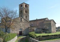
Pieve di Pernina is situated in Montagnola Senese, 2 Km away from Cetinale. The ancient Romanesque building, immersed in a dense ilex's wood and presents a simple architectonical style. The etymon probably from the Etruscan Perna, in latin Pernia - Pernaia (small noble). The Pieve di Santa Maria in Pernina, built in a beautiful stone filaretto is of the XII century. It has a basilican plan with three naves, divided by four crossings that meet in one apse. A few of the capitals present decorations with geometric designs, while the bases of the semi-columns take you back to various Sienese churches. The outstanding bell tower, about 22 meters high, with a squared base and terminal battlements is situated in front of the facade of the church. |
|
||
Pieve di San Giusto a Balli is situated at nord-east of Sovicille, on the right of the torrent Serpenna. This ancient Romanesque church was in origin with nave and two aisles, then was rebuilted with bricks and clear stone. At the end of the central nave there is a big apse, belonged to a previous early-Romanesque building. The small village of Torri, 14 km from Sienna, is famous for the Abbey of Santa Mustiola (Chiesa della Santissima Trinità e di Santa Mustiola) and its cloister. The Abbey, first recorded in 1070, was founded by Vallombrosan monks. The cloister is now the property of the Bicocchi family and may be visited on limited days of the week. Abazia di Santa Mustiola is an ancient monastic foundation of XII century. Actually used as villa-farm, the abbey conserves a beautiful quadrangular cloister with three superimposed orders : the ground order is Romanesque with arches sustained by pilasters; the median order is built with big octagonal pilasters; and the superior order is Renaissance with wood's columns. Castello di Poggiarello di Stigliano is a small castle and village located near Sovicille. The castle is located on the hill of Poggiarello, just above the village of Stigliano, into the Merse Valley, on the first slopes of the woody Colline Metallifere. The ancient tower and the castle enclose a space at the top of a hill, with panoramic views toward the skyline of the Siena’s towers in the foreground, and the Chianti Mountains. The history of Poggiarello reaches back at least as far as Etruscan times, shown by the remains of walled enclosures on the hill. There are traces of iron age settlements found in recent archaeological digs. Built in the 12th. C., Il Castello del Poggiarello di Stigliano served originally to protect the flourishing commercial development of the area. By the 14 C, Stigliano was probably the hub of the network of roads crossing the region, one to Massa Marittima and another following the Rosia river to the Maremma. All routes passed through the villages of Torri and Stigliano, and traces of the old roads can be seen in the woods nearby Stigliano. Hamlets such as Poggiarello were important as defense posts in the middle ages and even more so for the industrial development which flourished in the early middle ages when multi-national businesses developed. |
|||
Castello di Spannocchia is located about 12 miles southwest of Siena in central Tuscany. Castello di Spannocchia was built by the Spannocchi family in the 15 C, enlarged in the 18 C and then purchased by the Cinelli family in 1925. It includes a mediaeval tower, the original owner’s villa, and a farm, the Tenuta di Spannocchia. The Tenuta is an organic farm and forest and is part of the Region of Tuscany’s Riserva Natural Alto Merse nature reserve. |
|||
Ponte della Pia is the most charming bridge of this area. In Etruscan times an ancient road crossed it. The bridge has probably Roman origins and it has been rebuilt during the Middle Ages in Romanic style. The bridge linked the Merse Valley to the Maremma Toscana. According to some legends, the beautiful Pia, Nello d'Inghiramo de Pannocchieschi's sorrowful wife, crossed this bridge to go into exile in Maremma, at Castello della Pietra. Dante Alighieri wrote about this legend (Divine Commedy, Purgatorio, Canto V). |
|||
Going over it you reach St. Lucy's hermitage and the Spannocchia castle.
|
|||

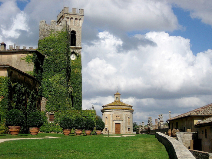 |
Castello di Celsa, chapel |
Walking in Tuscany | Southern Tuscany | Montalcino, Siena, Socicille, San Gimignano and the Val d'Elsa
|
|
Enlarge map |
Sovicille borders Casole d'Elsa, Chiusdino, Monteriggioni, Monteroni d'Arbia, Monticiano, Murlo and Siena. Rosia, San Rocco a Pilli, Stigliano, Torri and Volte Basse are frazioni of Sovicille. |
|
 |
Podere Santa Pia, overlooking lush green rolling hills in April |