The Pigelleto Nature Reserve in Piancastagnaio, between Siena and Grosseto, extends over a territory of 862 hectares. Pigello is the name the people of Amiata give to the white fir, a majestic tree that can reach heights of 50 m.
The Nature Reserve used to host one of the most important quicksilver mines of Monte Amiata, the Siele Mine, today completely abandoned. The Pigelleto Natural Reserve has been incorporated by the Regional Administration of Tuscany (Regione Toscana) in 1996. It used to host one of the most important quicksilver mines of Monte Amiata, today completely abandoned. The Environmental Education Centre La Direzione is inside the Reserve itself and includes the Visitors Centre, the Environmental Education Labs and facilities for visitors who wish to spend some time in peace and tranquillity.
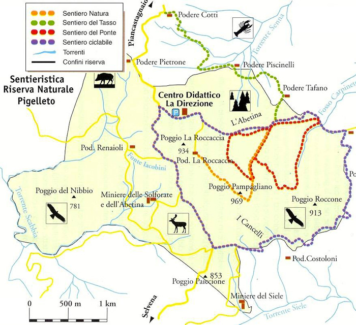
The Sentiero Natura (the Nature Trial) begins at Podere La Roccaccia and ends at the Environmental Education Centre 'La Direzione' for a 2.5 km long walk inside the Reserve. Along the way you will find many information sighs about the animals and palnts. At times it coincides with the trial n° 16 that connects Saragolo with the Siele Mines.
The Sentiero del Tasso (the Yew Trial) is part of Route n° 16 and is almost 2 km long. It takes you into the most beautiful and interesting part of the Reserve. This is why visitors must be accompanied by guides and rules are very stricted. During the trip you will see chstneut tress, beeches, silver firs and fern trees. There are also wet lands created by permant water sources.
The Sentiero del Ponte (Bridge Trial) has been traced by the community of Monte Amiata and is 4 km long. It is inside the Reserve creating an 8 whch then coincides with the Nature Trial. Along hte way there is a break area in an old ruin (podere s. Ignazio) surrounded by beeches.
The Sentiero Ciclabile (Cycling Trail) is part of the route n° 16 and n° 17 and is almost 6 km long. The asphalt roads are restricted to mountain bikes only. It runs through the woods of the Reserve and arrives at the cultivated lands that surround the Reserve. It goes up to Poggio Roccone and then down towards the Siele Mines.
There are many excursion paths that run through the Nature Reserve of Pigelleto. Some paths are part of the marked trail n° 16 (Saragiolo - Miniera del Siele - Castell'Azzara) and n° 17 (Pod. La Roccaccia - Castell'Azzara) created by the Town of Monte Amiata.
n° 16 Seragiolo-Miniera del Siele-Castell'Azzara
Continuing along the pathway n. 15, the road climbs a little till the crossroads to the Podere Praticce, and then it descends towards the Senna Torrnt and climbs again, around the Poggio La Roccaccia, till the homonymous farm house (not far from the farm house the pathway reaches the crossroads with the pathway number 17, known as â??Roccacciaâ??). Once got the Poggio Pamalliano over the pathway reaches the Cancelli crossroads and then the old mine.
The whole pathway, till the Siele mine, about 8 km long and of average difficulty, at an altitude of about 1000mt, can be covered in little more than 2 hours.
Going on once passed the mine, the pathway climbs up till the Ripa di Selvena, and then to the Poggio della Vecchia, the Spring Fossatelle, the Poggio Ciabattino, and then climbs down towards Castellâ??Azzara.
This last stretch, which can be covered only on foot or mountain bike, is quite demanding because of the uneven soil and for the difference of altitude of about 400 m (till 1200 m altitude) to be faced. On foot it can be covered in about 2 hours (6 km).
The pathway can be entirely covered by mountain bike but it is not unsuitable for the horses in the stretch from the Siele mine to Castellâ??Azzara.
It is possible, from the Ripa di Selvena, to climb down through a well-kept pathway of the Comunità Montana, till the village of Selvena, starting again then from Belvedere to return, through the, pathway n.19 to S. Fiora.
n° 17 Pod. La Roccaccia - Castell'Azzara
From Castell'Azzara with this pathway the valley of the Siele torrent till the Podere La Pinza can be crossed, and then the pathway continues towards the Podere San Filippo, the Fosso Carpineto and the Podere La Roccaccia, where it joins pathway n. 16.
As far as the final stretch of the pathway 17 is concerned, it coincides, in the area La Roccaccia, with the pathway 16.
The whole pathway, of about 8 km, is very demanding and difficult and can be covered only on foot and by fit excursionists in about 3 hours.
The altitude varies from the 800 m of Castellâ??Azzara, to 864 m, and then it climbs down to the 500 m of the Siele and climbs up again to about 1000 m.
An alternative is represented by a pathway of the Comunità Montana which, starting at about 1 km distance from the farm house La Pinza, goes towards the Podere San Francesco, and from here, passing southern from Poggio Roccone, it leads to the Podere Costoloni and then to the Siele mine, on the pathway 16, creating with stretches of the pathways 16 and 17 a small ring of the upper basin of the Siele river.
|