Abbadia San Salvatore

Abbey of Sant'Antimo

Albarese

Acquapendente


anghiari

Archipelago Toscano


Arcidosso


Arezzo


Asciano


Badia di Coltibuono


Bagni San Filippo

Bagno Vignoni

Barberino Val d'Elsa

Beaches

Bolsena Lake


Bomarzo

Brunello di Montalcino

Buenconvento

Campagnatico


Capalbio


Castel del Piano


Castelfiorentino

Castell'Azzara

Castellina in Chianti


Castelmuzio


Castelnuovo Bererdenga


Castiglioncello Bandini


Castiglione della Pescaia


Castiglione d'Orcia


Castiglion Fiorentino


Celleno


Certaldo


Chinaciano Terme


Chianti


Chiusi


Cinigiano


Città di Castello

CivitÀ di Bagnoregio


Colle Val d'Elsa


Cortona


Crete Senesi


Diaccia Botrona

Isola d'Elba

Firenze


Follonica


Gaiole in Chianti


Gavorrano

Gerfalco


Greve in Chianti


Grosseto


Lago Trasimeno


La Foce


Manciano


Maremma


Massa Marittima


Montagnola Senese


Montalcino


Monte Amiata


Monte Argentario

montecalvello

Montefalco


Montemassi


Montemerano


Monte Oliveto Maggiore


Montepulciano


Monteriggioni


Monticchiello


Monticiano


Orbetello


Orvieto


Paganico


Parco Naturale della Maremma


Perugia


Piancastagnaio


Pienza


Pisa


Pitigliano

Prato

Radda in Chianti


Roccalbegna


Roccastrada


San Bruzio


San Casciano dei Bagni


San Galgano


San Gimignano


San Giovanni d'Asso


San Quirico d'Orcia


Sansepolcro


Santa Fiora


Sant'Antimo


Sarteano


Saturnia


Scansano


Scarlino


Seggiano


Siena


Sinalunga


Sorano


Sovana


Sovicille

Talamone

Tarquinia


Tavernelle Val di Pesa


Torrita di Siena


Trequanda


Tuscania


Umbria


Val d'Elsa


Val di Merse


Val d'Orcia


Valle d'Ombrone


Vetulonia


Viterbo

Volterra


Walking in Tuscany
             
 
Giro del Monte Argentario

I T           D E U           


The Tour of Monte Argentario - 46.3 km

album Surroundings


Cycling in Tuscany| The Tour of Monte Argentario | The Silver Coast. Pristine beaches


The Tour of Monte Argentario
Orbetello - Porto Ercole - Punta Avvoltore - Strada Panoramica - Porto Santo Stefano - Orbetello


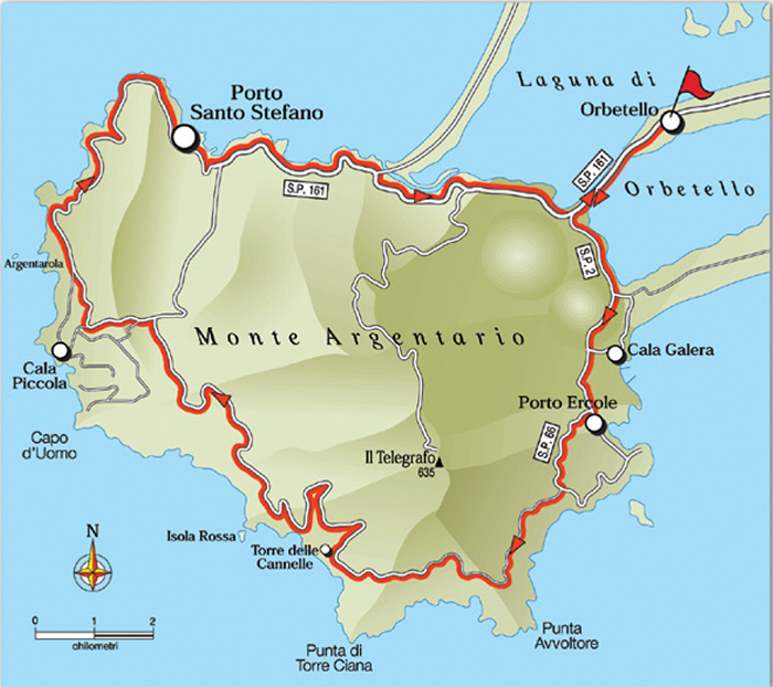
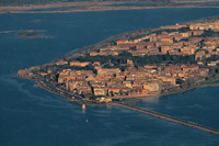
32. The Tour of Monte Argentario - 46.3 km


Punto di partenza e arrivo: Orbetello
Distanza: 46.3 km
Dislivello: 450 m
Tipo di strada: misto (asfalto + sterrato)
Bicicletta: tuttoterreno e MTB
Difficoltà: impegnativo

NOTES: A very scenic itinerary cycling through one of the most beautiful coast stretches of the whole Tyrrhenian seashore. The Silver Coast includes the territories of Monte Argentario (villages of Porto Ercole and Porto Santo Stefano), Orbetello, Magliano in Toscana, Capalbio and the Islands of Giglio and Giannutri.As far as the altitude
is concerned it requires a certain exertion because of its continual ups and downs bar the first 7 and the last 10 kilometres. However short a few stretches are very steep and a stretch of about 3.5 kilometres on a dirt track is very damaged requiring the use of all-terrain or MTB bikes.
The nearly total lack of traffic between Porto Ercole and Porto Santo Stefano and the extraordinary natural setting with a nonstop view of the sea make this itinerary one of the most interesting destinations for bikers and cycling excursionists.


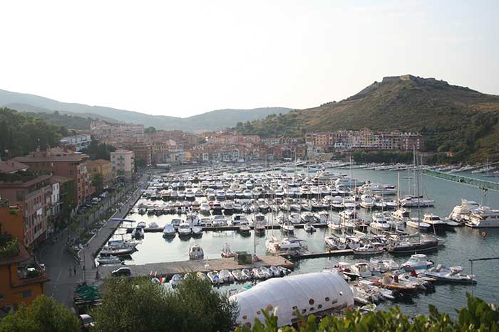
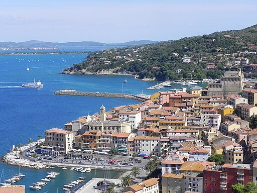
The square Mario Cortesini in Orbetello is the starting point of the itinerary. Following the road signs to Monte Argentario and Porto Ercole one pedals on the cycling lane following the provincial road S.P. 161 right in the middle of the Orbetello lagoon. After 2 kilometres one turns left in the direction of Porto Ercole and Cala Galera taking the S.P. 2 of Porto Ercole. Past the crossroads to Cala Galera and a short slope one reaches Porto Ercole (6.2) with its little harbour.

The road passes by the gate to the old town and with a spurt uphill the S.P. 66 “Panoramica Porto Ercole” leaves the urban area plunging into the lush green of pines and maquis. The view it offers onto the coast and the Isolotto is beautiful. The road climbs gently for 4 kilometres to clear the hill (10.5) plunging down a very steep slope. In front of the barrier of the old road (barred because of landslides) a few hundred metres afterwards one continues to cycle downhill as far as a crossroads keeping to the right towards the parking lot. Cleared a short stretch of dirt track one cycles up a steep tarred ramp for 500 metres returning onto dirt track which climbs less steeply clearing the hill (11.9). One starts cycling downhill bypassing the Punta Avvoltore. After a short while one starts climbing uphill on a large but damaged road. At this point of the itinerary the view is superb showing the coast between Punta Avvoltore and Punta di Torre Ciana. After about 1.5 kilometres uphill one clears the hill once more near a crossing from where one cycles straight on downhill on a damaged stretch. At the next crossing (14.4) one continues straight on returning onto a tarred road: the itinerary continues downhill for 2.8 kilometres and then the road dives into a very thick maquis full of strawberry and mastic trees. Then the view opens onto the coast with the Torre delle Cannelle and the Isola Rossa while one cycles gently uphill. At this point the road turns decidedly towards the inland to return then to the coast overlooking the craggy cliffs of the seashore and the Torre delle Cannelle, as well as the Torre Ciana farther away. Bypassing the headland from which the Isola Rossa and the wide Cala dell’Olio (21.5) can be seen the road turns decidedly towards the inland with a very exacting stretch of over 1 kilometre, marked by steep and narrow hairpin bends. One then continues on a, good to cycle on, upward slope that seconds the altitude curve with a few spurts. The environment becomes less wild and the maquis gives way to olive groves and drystone walls.

One continues uphill for about 2 kilometres as far as the area overlooking Capo d’Uomo (24.8) and clearing the hill to then cycle downhill for 1 kilometre as far as a crossroads (25.8) where one turns left following the road sign to the S.P. 65 “Panoramica” (continuing straight downhill one swiftly reaches Porto Santo Stefano). The long and very pleasant descent on a smooth tarred road offers a beutiful view of the coast with the Cala del Bove and the Isolotto di Argentarola and further of Cala Grande. On reaching Porto Santo Stefano one cycles as far as the roundabout (36.3) from where one continues in the direction of Porto Ercole and Orbetello on the S.P. 161 of “Porto Santo Stefano”. A short spurt uphill and then downhill towards the seashore. Past the locality Pozzarello (37.8) one cycles on without any difficulty as far as Orbetello (45.5) along the last 2 kilometres on the cycling lane in the heart of the lagoon already covered at the beginning. The itinerary ends in Piazza Mario Cortesini (46.3) where it started. [1]


Porto Ercole, darsena

Porto Ercole, harbour


Argentario: la grande traversata


Da Porto Santo Stefano a Porto Ercole passando per Punta Il Telegrafo, il punto più alto del promontorio.


Porto Santo Stefano


Photo gallery Porto Santo Stefano


Porto Vecchio Pilarella   Cala Grande dalla strada panoramica di Porto Santo Stefano  
P.S.Stefano panorama

Porto Santo Stefano


  Cala Grande dalla strada panoramica di Porto Santo Stefano  
Orbetello,  Il Molino Spagnolo
Torre di Cala Grande Monte Argentario  

Orbetello - Vista dal convento dei frati passionisti.JPG

  Porto commerciale del valle

La Torre di Cala Grande occultata dalla vegetazione


  Orbetello - Vista dal convento dei frati passionisti


Porto Santo Stefano


Porto San Stefano, Panorama dalla strada del sole

Bellissimo panorama di Porto Santo Stefano dalla strada del sole. Sullo sfondo il tombolo di Giannella. [1]


Il G.S.A. Grande Sentiero Anulare | Itinerario n. 086 - Promontorio di Monte Argentario


Starting point: Porto S.Stefano
Distance in kilometres km 39 - Difference in altitude 1370 m
Train: Si - stazione Orbetello 13 km
Lunghezza: 39 km
Ascesa accumulata: 1370 m
Quota massima: 585 mslm
Difficoltà tecnica CAI : MC
Indice IBP : 111
Tempo pedalato: 3h 50m
Sterrato: 72%

Description

The tour allows you to explore much of the Monte Argentario promontory capturing in full the beauty and spectacle. The route, which takes place entirely on asphalt and good dirt or cement road, is physically demanding for the total drop to deal with.

Informazione | www.paolaegino.it/MTB/schede/086sch.htm


Monte Argentario and Tombolo di Giannella, view from Scansano

Monte Argentario e Tombolo di Giannella, vista da Scansano


Photo gallery Porto Ercole


Porto Ercole - Vista porto.JPG


Porto Ercole - Vista fortezza dalla rocca 2.JPG


Porto Ercole - Vista Laguna dalla rocca.JPG

Porto Ercole - Vista porto


  Porto Ercole - Vista fortezza dalla rocca   Porto Ercole - Vista Laguna dalla rocca
Porto Ercole - Vista porto dalla rocca  

Porto Ercole - Vista rocca e fortezza 2.JPG


Porto Ercole - Salita alla fortezza dalla rocca.JPG

Porto Ercole - Harbour view from the "rocca"


  Porto Ercole -Vista rocca e fortezza  
Porto Ercole - Salita alla fortezza dalla rocca


  Orbetello, Duomo   Cosa
Fish production in Orbetello  

Orbetello, Duomo


  Cosa


31. Il giro della laguna di Levante | The Tour of the Eastern Lagoon - 25 km

Orbetello - Località Terrarossa - Tombolo della Feniglia - Ansedonia (Cosa ) - Via di Camerette - Orbetello Scalo - Orbetello

33. La bassa valle dell’ Albegna | The Lower Albegna Plain - 89 km

Orbetello - Strada di Camerette - Ansedonia (Cosa ) - Oasi WWF Lago di Burano - Chiarone Scalo - Garavicchio (Giardino dei Tarocchi) - Borgo Carige - Capalbio - Marsiliana - Magliano in Toscana - Quattrostrade - Orbetello Scalo - Orbetello


[1] Foto di Ceppicone, licenziato in base ai termini della licenza Creative Commons Attribuzione-Condividi allo stesso modo 3.0 Unported