| |
|
| |
|
|
|
|
|
|
| |
 |
 |
|
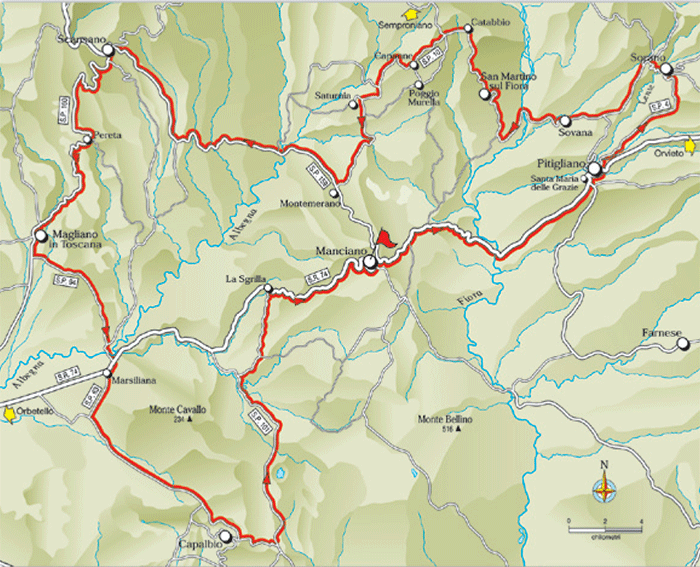
Along the routes of the Champions - 169.4 km[1]
|
|
 |
 |
| |
|
|
|
| |
|
Cicloturismo in Maremma | Along the routes of the Champions
|
|
|
|
| |
|
| Along the routes of the Champions
Manciano - Pitigliano - Sorano - Sovana - San Martino sul Fiora - Saturnia - Montemerano - Scansano - Pereta - Magliano in Toscana -
Marsiliana - Capalbio - La Sgrilla - Manciano
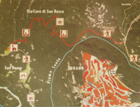
18. Along the routes of the Champions - 169.4 km
MANCIANO Km 0 - PITIGLIANO Km 18,5 - SORANO Km 27,5 - SOVANA Km 37,5 - SAN MARTINO SUL FIORA Km 47,5 - SATURNIA Km 62,5 - MONTEMERANO Km 68,5 - SCANSANO Km 89,5 - PERETA Km 99,5 - MAGLIANO IN TOSCANA Km 107,5 - MARSILIANA Km 125,9 - CAPALBIO Km 139,9 - LA SGRILLA Km 160,4 - MANCIANO Km 169,4
Starting point and arrival: Manciano
Distance in kilometres: 169.4 km
Difference in altitude: 2.255 m
Type of road: tarred road
Bicycle: roadster
Difficulty: exacting
NOTES: The itinerary follows faithfully the route of the Granfondo Massimiliano Lelli with the code GR6 of the provincial cycling routes. It is an itinerary requiring a good basic training both on the distance in kilometres (nearly 170 kilometres) and the difference in altitude. It does not present too steep stretches nonetheless it keeps up a pace that follows perfectly the hilly countryside of Maremma, alternating long distances of ups and downs. Those cycling as tourists keeping a slow pace are advised to complete the itinerary in 2 or 3 stages.
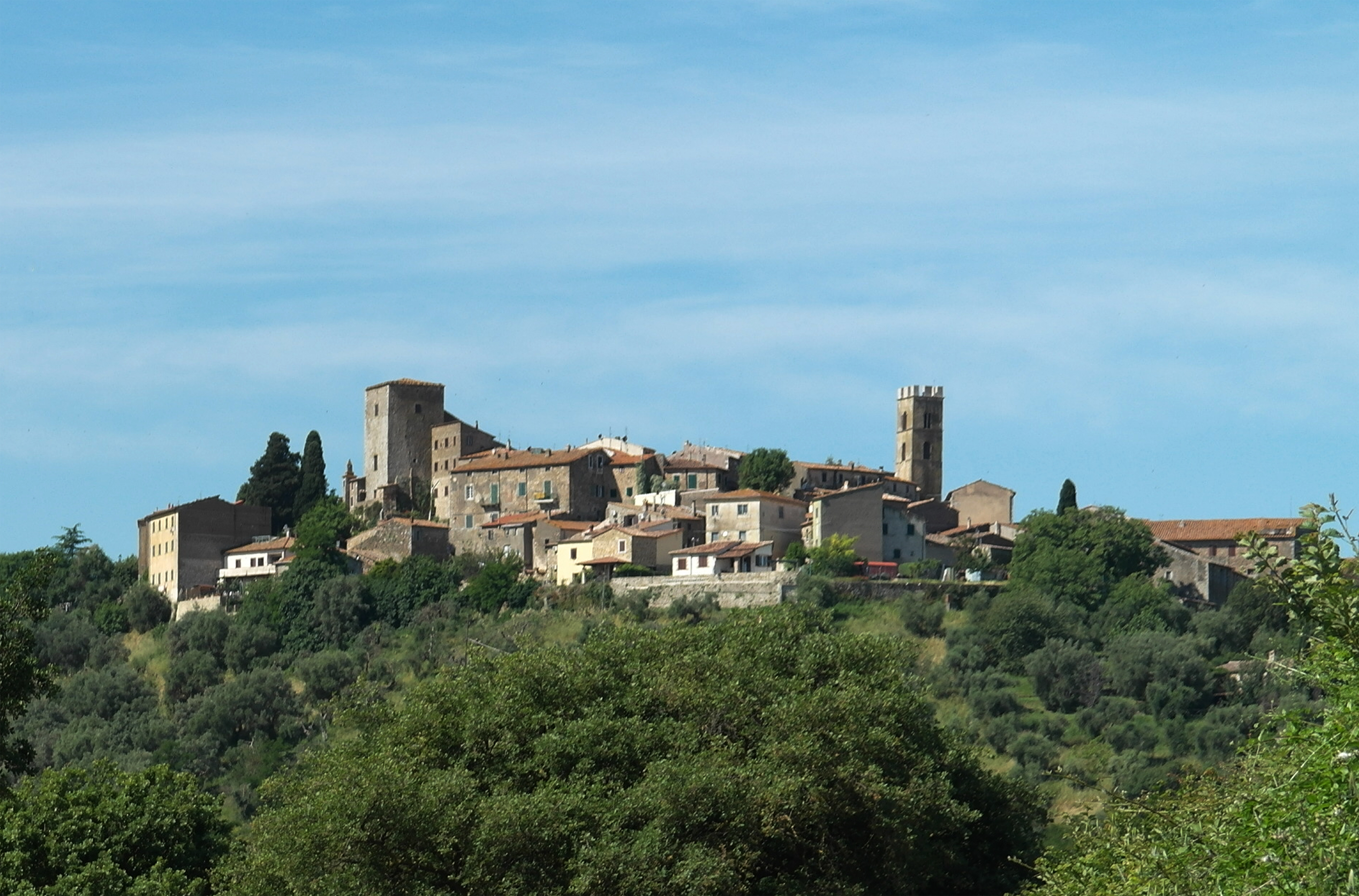
Leaving Manciano on the regional road S.R. 74 in the direction of Pitigliano one cycles mainly downhill as far as the bridge over the river Fiora (10) from where one cycles on uphill towards Pitigliano, to be seen from the observation point of Santa Maria delle Grazie after about 6.5 kilometres. One reaches the town of Pitigliano cycling for 1.2 kilometres downhill and 800 metres uphill (18.5). Here one leaves the S.R. 74 to take the provincial road S.P. 4 in the direction of Sorano reaching it without any particular difficulty after about 9 kilometres on a smooth stretch.
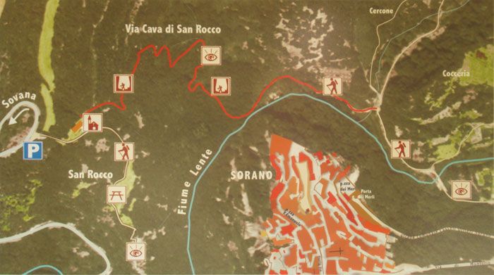
From central Sorano (27.5) one takes the S.P. 22 stretching decidedly downhill along hairpin bends, hollowed out of high tuff walls, to the bottom of the river Lente valley. Past the bridge one cycles uphill for about 2 kilometres on the S.P. 22 here again between impressive tuff walls passing by the Via Cava of San Rocco. One reaches a plateau and then cycles down a gentle slope towards Sovana (37.5) taking the last 2 kilometres at a high speed on the steep slope. Leaving Sovana in the direction of San Martino sul Fiora one crosses the archaeological site of the Ildebranda Tomb and the Cavone, an important Etruscan Via Cava (hollowed out road). After about 7 kilometres past the bridge over the river Fiora, the ascent to San Martino sul Fiora (47.5) begins. (47.5).[1]
|
 |
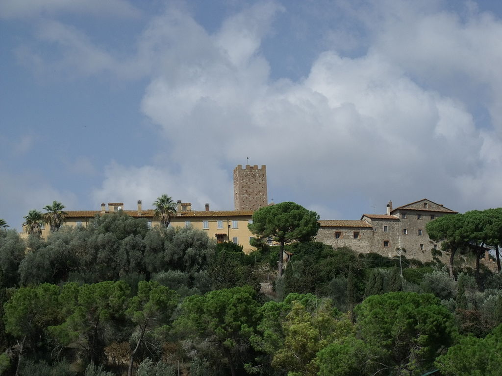
Panorama di Pitigliano [2]
|
|
|
|
| |
|
The itinerary carries on in the direction of Catabbio (ignoring the detour in the direction of Semproniano on the right) and then on the S.P. 10 “Follonata” towards Capanne where it then descends in the direction of Saturnia. Passing by the crossroads to the town of Saturnia and the thermal baths (62.5) one cycles uphill along a panoramic stretch of the S.P.10 as far as the S.P. 159 near Montemerano (68.5). Here one turns right descending as far as the bridge over the river Albegna (72.5) where the gradual and fair ascent to Scansano (89.5) begins. Having reached the town centre the itinerary carries on downhill along the fair S.P. 160, surrounded by lush vegetation, crossing Pereta (99.5) and then through the typical hills of the Maremma countryside as far as Magliano in Toscana (107.5). From Magliano in Toscana one takes the S.P. 94 “Sant’Andrea” and cycles on an even and pleasant descent crossing the bridge over the river Albegna to reach the S.R. 74. At the crossing (116.7) one turns right, swiftly reaching in 400 metres the urban area of Marsiliana (125.9), where one leaves the S.R. 74 to take the S.P. 63 “Capalbio”.[1]
|
 |
Marsiliana d'Albegna[6]
|
For the first 3 kilometres the road carries on with ups and downs to stretch then on the plain across vineyards, tilled fields and maquis. Another stretch with ups and downs before the ascent of about 2 kilometres towards the town of Capalbio (139.9). At the T-crossing one turns left on the S.P. 75 “Pescia Fiorentina” that leaves the urban area skirting the cemetery. The road is very pleasant to the eye, fringed by stone walls and surrounded by the green of the olive groves and oak and holm oak woods, and mainly downhill. After 3 kilometres one leaves the S.P. 75 to take, on the left, the S.P. 101 “Sgrilla” in the direction of Vallerana and Manciano. Still 9 kilometres to cycle and one arrives at Vallerana (151.9) to reach, a pair of kilometres later, a crossing where one turns right onto the S.P.101 as far as the locality La Sgrilla (160.4). From here one turns right taking the S.R. 74 and cycling uphill for 9 kilometres in the direction of Manciano (169.4).[1]
|
 |
Sovana, piazza [3]
|
 |
Duomo di Sovana [3]
|
|
|
| |
|
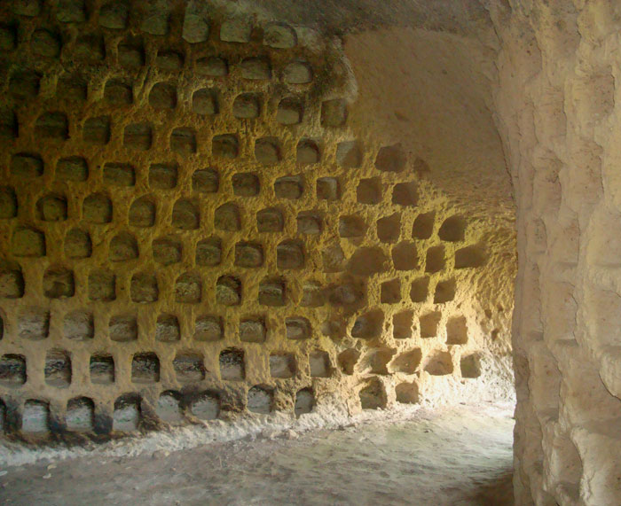
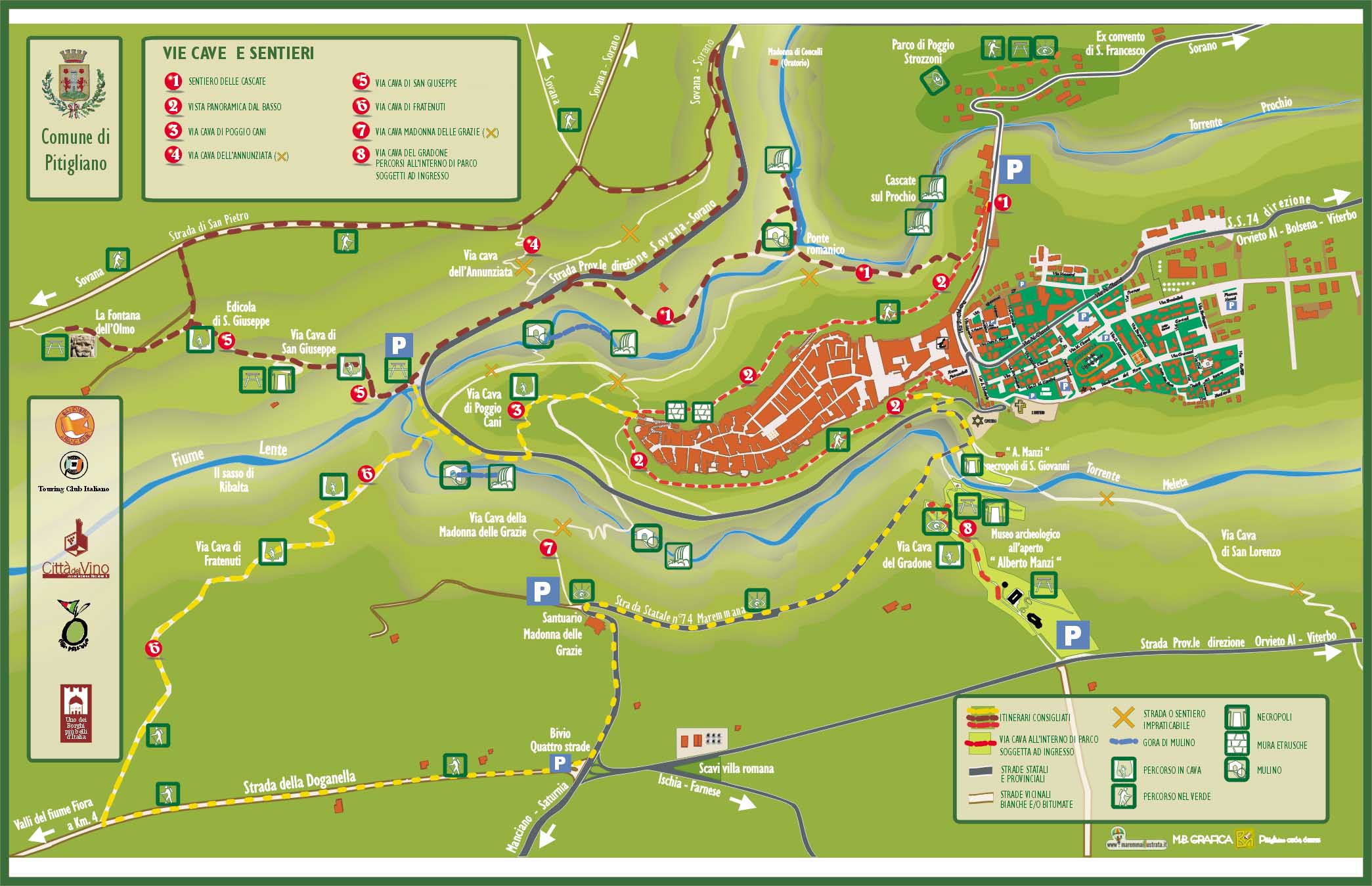
The Sunken roads or Vie Cave around Pitigliano
|
Around Pitigliano, there are various Vie Cave, "sunken roads" carved out by the Etruscans during the Bronze age, including one towards the archaeological area of Sovana.
|
Among others, there are to remember Le Vie Cave del Gradone, Le Vie Cave di San Giuseppe and Le Vie Cave della Madonna delle Grazie.
South of Pitigliano is the open air archaeological museum, il Museo archeologico all'aperto Alberto Manzi. There are picnic facilities here as well as a vie cave, the Via Cava del Gradone and the Necropoli di San Giovanni.
A printable PDF map can be downloaded from the comune di Pitigliano.
|
|
 |

|
|
|
|
|
 |
|

|
|
 |
| Sorano, Porta di Sopra |
|
Sorano, veduta
|
|
Il Masso Leopoldino
|

|
|
 |
|
 |
| Fortezza Orsini |
|
Rupestre di Vitozza, La Chiesaccia
|
|
Vie Cave San Rocco |
| |
|
|
|
Sulla strada che da Sovana conduce a Sorano, la Via Cava di San Rocco (e parcheggio) si trova sulla sinistra, due chilometri prima di entrare Sorano
|

|
|
|
|
|
 |
|

|
|
 |
|
|
|
|
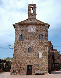
Chiesa di Santa Maria Maggiore
|
 |
|
 |
|
 |
Palazzetto dell'Archivio
|
|
|
|
Chiesa di Santa Maria Maggiore, affresco Madonna col bambino e santi (1508) |
|
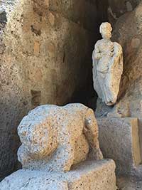
Sovana, Chiesa di San Mamiliano. Etruscan terracottas in the Museo di San Mamiliano, Etruscan statuette #poderesantapia
|

|
|
|
 |
|
 |
|
 |
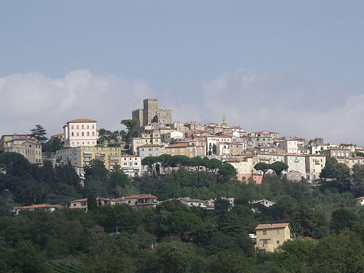
Manciano
|
|
Montemerano, panorama
|
|
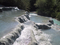
Saturnia, Cascate del Gorello
|

|
|
|
 |
|
 |
|
 |
Panorama Scansano
|
|
Tenuta dell'Ammiraglia dei Marchesi de' Frescobaldi, Magliano |
|
Particolare del giro delle mura
|
| |
|
|
|
|
Itineraries trough the Etruskan Vie Cave
From Pitigliano to Sovana, along the vie caveand the Necropolis of Poggio Felceto | Download pdf
From Sovana to Via cava di San Sebastiano and the Tomba della Sirena (Siren Tomb) | Download pdf
From San Martino sul Fiora to Sovana
From Sorano to Vitozza, along the vie cave and the Necropolis of Poggio Felceto (download pdf)


Podere Santa Pia is the ideal holiday base for your holidays in the Tuscan Maremma. The Maremma embraces the Tyrrhenian coast and the inland hills that stretch from Massa Marittima to Capalbio, and includes the area of Monte Argentario and the islands of the Grosseto archipelago, up to Saturnia and the Tuff Area of Sovana, Sorano and Pitigliano, and to Monte Amiata, the highest extinct volcano in Italy, reaching 1736 metres. The surrounding area contains volcanic lakes, rugged rocks, river sources and several protected areas. Sparsely populated, it consists mostly of small towns spread throughout the valleys.
Nearby villages and cities guarantee the proximity to a wide choice of gorgeous Tuscan and Maremma restaurants, osterie, trattorie where the unique flavour of the typical Tuscan cuisine will surprise you. The manual of the house provides a list with good descriptions and best choices, intended as a useful suggestion for those who want to complete their holiday with la dolce vita italiana.
Turismo in Toscana | Case vacanza in Toscana | Podere Santa Pia
|
| |
|
|
|
|
|
|
|
Podere Santa Pia |
|
Podere Santa Pia |
|
Saturnia
|
| |
|
|
|
|
| |
|
|
|
|

Cicloturismo in maremma l 35 percorsi ciclistici
Cycling in Tuscany | Cycling tours in Southern Tuscany
Itinerari | From Sorano to Vitozza, along the vie cave
Parco Archeologico | Sorano - La regione dei Tufi | www.leviecave.it
All'interno del Parco Archeologico Città del Tufo, le Vie Cave di Sorano e Sovana conducono il visitatore alla scoperta delle necropoli etrusche.
|
|
Sovana, Sitio Archeologico, agrandire mappa
|

[1] Source: Cicloturismo Toscana | www. maremmabike.it
[2] Foto daLibens libenter, licenziato in base ai termini della licenza Creative Commons Attribuzione-Condividi allo stesso modo 3.0 Unported
[3] Fonte foto:Sailko, llicenziato in base ai termini della licenza Creative Commons Attribuzione-Condividi allo stesso modo 3.0 Unported
[4] Source: Campeggio Amiata, le foto dell’Assemblea davanti al cantiere di Bagnore 4 | www.recommon.org
[5] Foto da Giovanni Casalini, rilasciato nel pubblico dominio.
[6] Foto LigaDue, licenziato in base ai termini della licenza Creative Commons Attribuzione-Condividi allo stesso modo 4.0 Internazionale.
|
 |
| Colombari a Sorano [Photo Rein Ergo] |
|
|
| |
|
|
|
| |
|
|
|
| |
|
|
|
| |
|
|
|
| |
|
|
|
| |
|
|
|
