
 |
|
Ribolla | A mining walk
|
|
Ribolla | A mining walk |
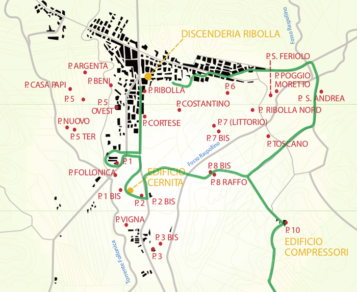
The history of Ribolla begins when natural deposits of brown coal were discovered along the river Raspollino, around the year 1835. The first mines were digged during the Thirties and Forties in the Nineteenth century, during the government of Leopoldo II di Lorena. |
The first settlement, which then will develop into the mining town, was built around the mining shaft named “Ribolla”. The train track built in 1892 allowed increasing the production of the mine while decreasing transportation expenses. Nevertheless the main development and population increase of Ribolla occurs in the Twentieth century, in particular in the year 1924, when the Montecatini Company becomes the only owner of the mine. The increasing energy demand during the First and the Second World War determines the need to push the production of the mine, which in 1942 reaches 270 thousand tons of coal. This production increase is in turn parallel to the manpower increase. In 1947 more than 3700 men are employed in the mine. Right around this period, when people are attracted to the mine looking for employment opportunities, the Montecatini Company starts laying-off the mining workers. The social condition in town becomes so critical and desperate that the miners are engage in a severe strike, also known as the “the five months fight”. This fight, against the extremely long working hours and poor working conditions, however, does not bring to a positive result. The newly hired manager, Dr. Padroni, determines that the mine is not productive any more and that significant measures need to be taken in order to reduce the operational costs. Even the technique used for the exploitation of the mine is driven by cost rather than environmental safety. The working conditions and personal safety of the mining workers are getting worse and worse until the morning of May 4th, 1954 a tremendous explosion takes the lives of 43 miners and destroys the Camorra mine. The court case, begun shortly after the explosion, ends in 1958, when the judge dismisses all the charges against the managers and owners of the mine. The fate of Ribolla becomes clear in 1959, when all the mines are shut down. After a brief decommissioning, any trace of what used to be the primary motivation of life for the population of Ribolla suddenly disappears. The only reason that saved Ribolla from becoming a ghost town was the opening of new chemical and industrial plants in the nearby towns of Gavorrano, Boccheggiano, Scarlino and Piombino. Historic places 1. The Movie theatre. Built with the contribution of the mining workers around the Forties, this was the place where the social life of the inhabitants of Ribolla took place. The movie theatre hosted happening nights, opera, and musicals famous during the forties and fifties. In 1954 it was used as funeral home for the 37
Downloads - Allegati
|
|
||||
 |
 |
 |
||
Tombola di Feniglia, view from Between Ansedonia and Porto Ercole lies the gorgeous sandy beach stretching from Feniglia for 6 km. You can only reach this part by foot or bicycle as this park is unter nature protection. |
Parco Naturale della Maremma
|
Principina a Mare
|
||
In the southwest of the Maremma is an area little known even by Italians, called the Metal Hills, the Colline Metallifere. With only a few major urban centers, like the beautiful Massa Marittima, it is an area populated by fortified villages still preserving their medieval form. Between them lie dense woods and solitary valleys, against which rise the steep mountains that diminish only as one reaches the coast. On the littoral, marshes —salty, but fertile— constituted one major economic resource. But the true treasure of this region is underground, where the earth is packed with major mineral resources: iron, copper, lead, and silver. Massa Marittima is the historical capital of the mining territory of the Metalliferous Hills. As of the medieval period, the wealth of minerals extracted on its territory permitted the city to adorn itself with civil and religious buildings that had nothing to envy of the greatest centres of the epoch. Today, the local system of museums valorises the artistic and scientific tokens of its glorious past. Roccastrada, a village in the heart of the province, is starting point of a wide net of more than 150 km pathways leading through this area full of natural beauty and historic locations. Roccatederighi is one the Maremma's most interesting medieval villages. The village of Roccatederighi is located on a spur with spectacular views over the plains of the Maremma below. Situated at an altitude of 538 m above sea level and hidden amidst gigantic rocks of rhyolite, called masses, its profile marked by towers and rooftops stands out perfectly against the surrounding nature and countryside. | ||||
| Source: Comune Roccastrada | www.comune.roccastrada.gr.it | ||||