| |
|
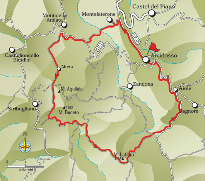
The Three Passes
Arcidosso - Montelaterone - Bivio Monticello Amiata - località Alteta - bivio monte Aquilaia - Valico Buceto - Bivio Monte Labbro - Località Merigar - Località Aiole - Arcidosso
19.The Three Passes - 30.7 km
ARCIDOSSO Km 0 - MONTELATERONE Km 3 -BIVIO MONTICELLO AMIATA Km 8,2 - PODERE DELL'ALTETA Km 10,8- (MONTE AQUILAIA) Km 12,3 - VALICO BUCETO Km 16,4 -BIVIO MONTE LABBRO Km 18,4 - LOCALITA' MERIGAR Km 26,1 -LOCALITA' AIOLE Km 27,5 - ARCIDOSSO Km 30,7
Starting point and arrival: Arcidosso
Distance in kilometres: 30.7 km
Difference in altitude: 990 m
Type of road: 22 km dirt track + 8.7 km tarred road
Bicycle: MTB
Difficulty: exacting
NOTES: There are no technical difficulties but the differences in altitude marked by three climbs require a good training. From the point of view
of the landscape the itinerary is very fascinating and offers unforgettable views.
From Arcidosso one leaves in the direction of Grosseto on the provincial road S.P. 26. After 3 kilometres one turns left towards Montelaterone and after about 100 metres to the right, right at the signpost bearing the name of the town, without starting the ascent towards the town, one turns left past a little church and begins the steep descent (dirt track and concrete) of 1.2 kilometres reaching the valley bottom and the river. Past the bridge one keeps to the right cycling on the dirt track which shortly afterwards (concrete surface) crosses a stream bed; one keeps to the left always following the main track climbing for about 2 kilometres as far as the tarred road (S.P. 7) where one continues on the right towards Monticello Amiata (8.2) 1.2 kilometres away.
At the signpost indicating the town one turns left following the road sign to the sporting facility with a short spurt uphill and skirting the sports ground. The dirt track climbs continuously; it plunges into the pine and chestnut woods reaching a crossing (locality Alteta) after 2.6 kilometres. Here one finds a few old isolated farmhouses and turns right towards the Mount Aquilaia. Here starts the most exacting stretch because of the uneven surface and the very steep slope.
After 800 metres one crosses orthogonally the dirt track “Salaiola- Stribugliano” and continues bypassing the Mount Aquilaia (on one’s left) on a very panoramic dirt track overlooking the coast.
After 700 metres a deviation is possible on the left to reach the peak of Mount Aquilaia (1.5 kilometres and 100 metres difference in altitude) while the itinerary continues straight on downhill for 1.7 kilometres with a few very steep stretches, as far as a dirt track, where one turns left and starts uphill once more cycling for 2.4 kilometres as far as the pass of Buceto (16.4). A little later the descent begins and one cycles straight on (avoiding the detour on the left, 500 metres after the pass) along the main track in the direction of Mount Labbro in full view in front of us. At exactly 1.3 kilometres from the pass the road joins diagonally another larger directrix: at this point one turns right curving back with a U-bend and picking up again the direction of Mount Labbro. After 700 metres the road forks off: keep to the left.
One cycles on a level road for 1.7 kilometres as far as the beginning of the climb to Mount Labbro (1.3 kilometres away, on the left, there is the track to the peak). At the end of the climb (21.4) one bypasses the slopes of the rocky relief to then plunge into a pleasant descent on a dirt track with a smooth surface reaching (2.6 kilometres) the detour to the left towards the Wildlife Park of Mount Amiata ending (after further 600 metres) near a crossing: on the right one takes the tarred road while the itinerary continues on the dirt road right in front, climbing (first crossroads on the right) for 2.3 kilometres towards the locality Merigar (26.1), a center of Buddhism and Tibetan Culture. Past the Buddhist center the dirt road comes to an end and a steep descent leads again onto tarred road at the locality Aiole. From here one turns to the left and cycles downhill as far as Arcidosso (30.7).[1]
Nature Reserves
Riserva naturale Poggio all'Olmo
The Poggio all’Olmo Nature Reserve extends for 400 hectares and is located in the Province of Grosseto on the high side of the Ribusieri Stream, a tributary of the Orcia River. It surrounds the peaks of Poggio all’Olmo, Poggio Materaio and Poggio la Torretta. Its altitude ranges from 800 to 1,000 meters and it offers extraordinary views of the Ombrone Valley, the volcanic Monte Amiata and the sinuous Val d’Orcia.
In this oasis, you’ll find lush black pine forests, chestnuts and fir in addition to broom, various types of fern, Etruscan violets and other flowers that grow in the calcareous soil typical of the mountains of southern Tuscany. On the peak of Poggio all’Olmo, you’ll find a ten-foot tall pear tree; it’s one of the monumental specimens you’ll see in the area, along with walnut and chestnut trees that are various centuries old.
The oasis also hosts a wide range of animal species such as the rodent-hunting wild cat, hares and wild rabbits. There are many birds in the area including diurnal birds of prey like the Pilgrim Falcon and the hawk. Thanks to its ample water supply, it is home to amphibians like the spectacled salamander and the yellow-bellied toad. In spring and summer, the area hosts several species of butterflies and bees.
How to get there
There is an entrance in Castiglioncello Bandini, one above the Castiglioncello Bandini cemetery, turn right just before Podere Fonte Canale, and one on the road between Castiglioncello Bandini and Stribugliano (on the left).
Another itinerary starts in Monticello Amiata (near the cemetery).
Coordinates:  42°52′11″N 11°27′22″E (Mappa) 42°52′11″N 11°27′22″E (Mappa)
|
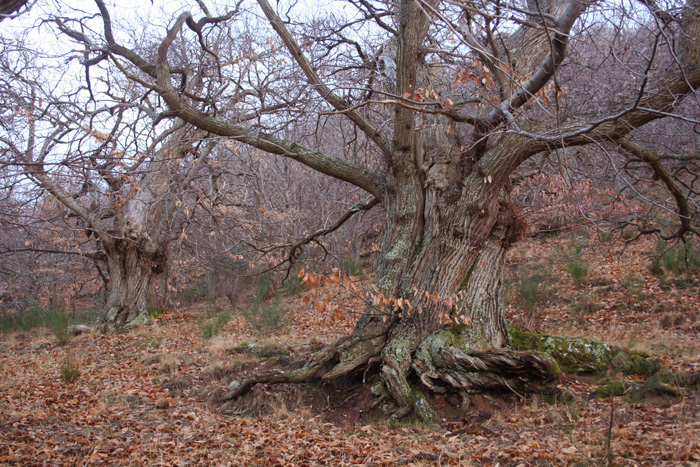 |
Old chestnut trees, La Riserva naturale Poggio all'Olmo, Castiglioncello Bandini
|
In Monticello Amiata two appealing naturalistic paths are available: “Via della castagna” and “Via delle Fonti”.
Via della Castagna, thematic itinerary that is set up around Monticello Amiata, with trails that wind through forests of chestnut trees.
Via delle Fonti, thematic itinerary which is divided between the two sources that supply the village of Monticello Amiata, which are located in two separate locations outside the country.
Cascata dell'Acqua d'Alto, situata sopra la frazione dei Bagnoli, sotto al Sasso della Vettoraia, è alta 25 metri ed è stata per anni inattiva dopo che Siena ne aveva sottratto l'acqua, privando gli arcidossini della cascata e causando carenze di approvvigionamento idrico. È stata recentemente riaperta.
Grotta di Merlino, situata presso San Lorenzo, si tratta di un antro che la tradizione vuole ricondurre a rifugio del celebre mago Merlino, anche se altre leggende la vedono come tomba di un guerriero etrusco, o nascondiglio di un ribelle fiorentino in fuga dagli spagnoli. Sopra la grotta tra il castagneto si trova una pietra lavorata, possibile ara sacrificale o forno fusorio medievale.
Monte Labbro Nature Reserve
Mount Labbro (or Labro) is located south-west of Mount Amiata. The reserve extends for over 650 hectares, between the Zanconato River and the Onazio, its northern tributary. The Albegna River constitutes its southern border. The entire area hosts medium-range mountains with summits, like Mount Labbro’s, that can reach as high as 1,190 meters.
The reserve is characterized by a low number of trees, which generally dot the area surrounding the Onazio River. There, you can find Turkey oaks, chestnut, elm, hazel and maple. Chestnut trees can mainly be found on the northern side of Mount Labbro, which covers an area of 60 hectares.
The area’s agriculture is based on traditional crops and pasture. Its fauna is represented by numerous species, some of which are of community interest. It is also characterized by the presence of mammals such as wild cats, polecats, stone martens, martens and badgers. The area is located in a strategic position for the migration of falcons. In addition to migratory species, you can also see eagles, buzzards, harriers, lanners and many more. Birds of prey are also present, in addition to several other species. The area’s reptiles include water snakes, grass snakes and Hermann turtles. Its geology features limestone formations, including calcarenite, argillites and diapri. Karstic phenomenon have created various caverns and caves throughout the area.
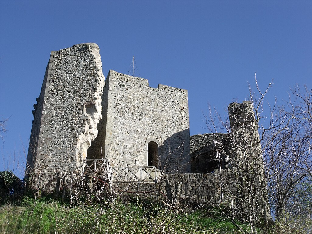
On the summit of Mount Labbro, visitors will appreciate the presence of several buildings of historical and cultural importance, which date back to the Giurisdavidico Movement of David Lazzaretti. [5]
Parco Faunistico del Monte Amiata
Within the Monte Labbro nature reserve, exists, for some time, the Amiata Fauna Park, or Parco faunistico del Monte Amiata, managed by the Mountain Community. The park covers 120 hectares and is defined by engineers, a "Wild Park" on the German model: Here the animals live in conditions of freedom. Among deer, fallow deer, mouflon and chamois and roe deer. By observation fences as a lucky visitor can happen even spot the Apennine wolf. [5]
This is not our favorite Nature Reserve.
Nature Reserves in Southern Tuscany | Parco Faunistico del Monte Amiata (it)
|
 |
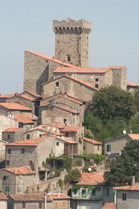
Cassero senese (Roccaccia, Rocca, Castello) in Montelaterone, frazione di Arcidosso [3]
|
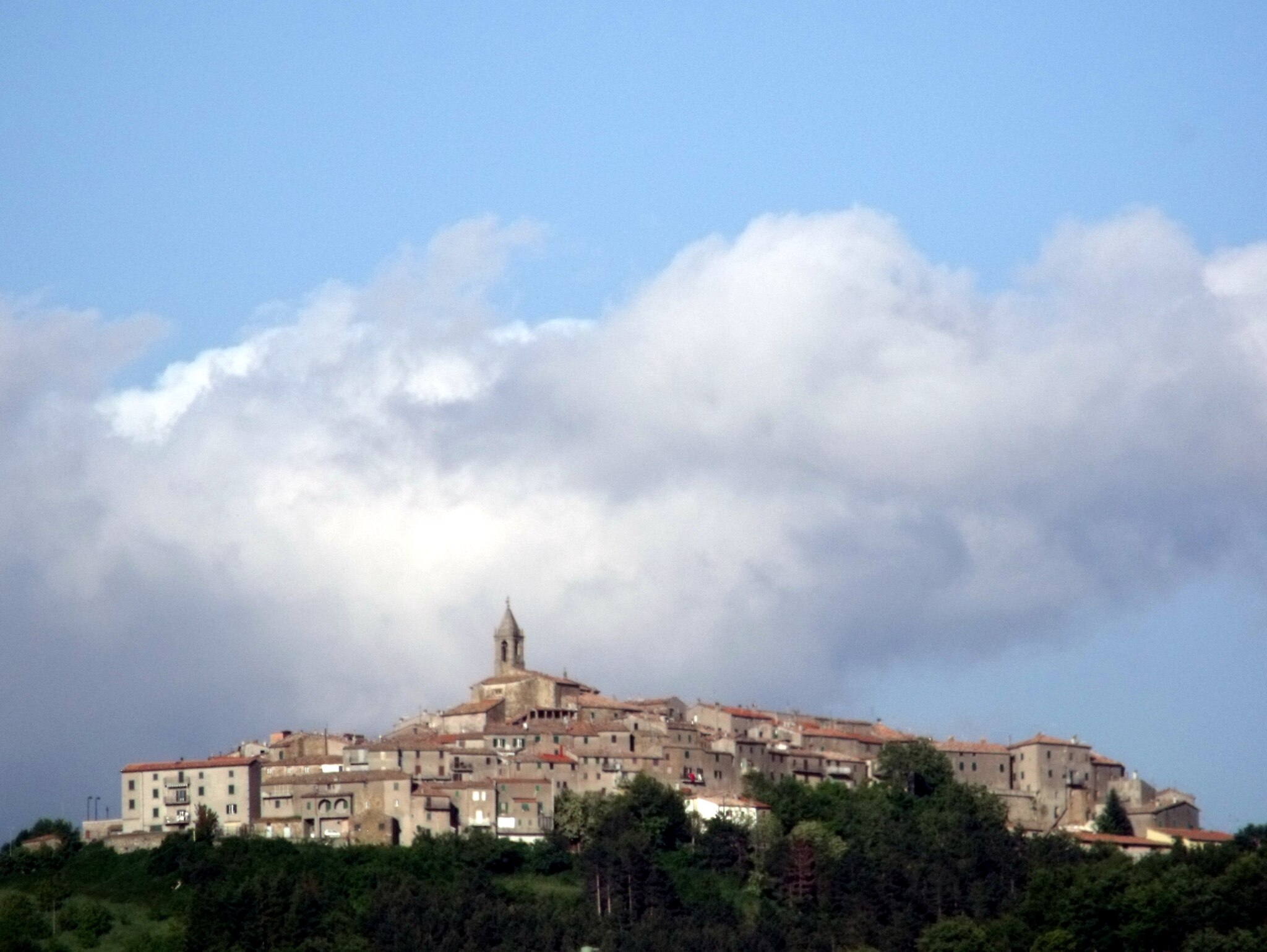
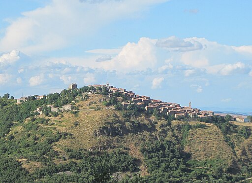
Montelaterone
Montelaterone is about 4 km from Arcidosso, and it is situated on a sandstone peak between the valleys of Ente and Zancona rivers. Main sights include the Pieve of Santa Maria a Lamula (an important and ancient Romanesque church, 12th century), between Montelaterone and Arcidosso.
Monticello Amiata
Monticello Amiata, antico centro medievale che si trova lungo la strada che conduce verso il Monte Amiata, alle porte della Riserva naturale Poggio all'Olmo. Geograficamente, si trova in un'area di alta collina che segna il definitivo passaggio dalla Valle dell'Ombrone al massiccio del Monte Amiata.
Castiglioncello Bandini
Castiglioncello Bandini, insediamento che sorse come castello per il controllo della parte orientale del territorio comunale di Cinigiano, ai piedi della Riserva naturale Poggio all'Olmo. Si sviluppò in epoca medievale e fu in possesso della famiglia Aldobrandeschi.
Poggio all'Olmo
La riserva naturale Poggio all'Olmo è un'area protetta della provincia di Grosseto che si estende attorno all'omonima altura, interessando parzialmente i territori comunali di Arcidosso e Cinigiano.
|
 |
|
 |
|
 |
Castiglioncello Bandini album
|
|
Castiglioncello Bandini |
|
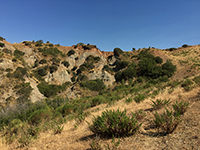
Castiglioncello Bandini, Calanchi in the valleybeween Podere Santa Pia, Federano and the torrent Rancida
|
| Monte Aquilaia
|
|
Mount Aquilaia (1,104 meters) is a mountain that rises on the western end of the volcanic cone of Mount Amiata, in the northwest of Mount Buceto, and together with the northernmost Poggio all'Olmo delimits the eastern territory of the Valle dell'Ombrone.
The mountainous relief rises to the western limits of the municipality of Arcidosso, just north-east of the town of Stribugliano and Salaiola; its north shore is included in the natural reserve Poggio all'Olmo.
42°51′11.52″N 11°28′30″E (Mappa)
|
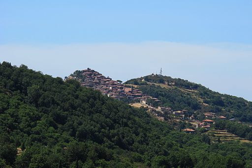
Stribugliano
Stribugliano is about 18 km from Arcidosso, situated on a peak of Monte Buceto above the valley of Melacce, between Castiglioncello Bandini and Roccalbegna.
Hang gliding and Paragliding
Stribugliano is a takeoff in front of Monte Buceto for hang gliding and paragliding. The takeoff is made of grass and it's wide open. It tilts gradually allowing for easy takeoff, both single and tandem. Recently a south takeoff has been discovered, however locals recommend only using western takeoff.
Informazion weather forecast, wind directions, wind speed | www.paraglidingmap.com
MAP
|
 |
|
 |
|

|
Monte Buceto |
|
View of Stribugliano, Arcidosso
|
|
Deltaplano e il parapendio (1) |
Monte Buceto
|
|
|
Monte Buceto (1,152 meters) is a mountain that rises on the southwestern end of the volcanic cone of Monte Amiata, in the northwest of Monte Labbro, and together with the nearby Mount Aquilaia delimits the territory east of the Ombrone Valley and north of the area of the Albegna and Fiora hills.
The mountainous relief rises to the south-western limits of the city of Arcidosso area, just east of the resort of Stribugliano; in its south-eastern shores lies the source of the river Albegna.
41°53′24.61″N 12°29′32.17″E (Mappa)
|
Aiole
Aiole is situated across the road from Arcidosso to Santa Fiora. From here a path allows you to reach the Tibetan Centre Merigar West.
Merigar West
|
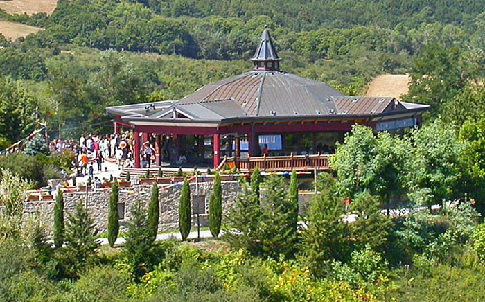 |
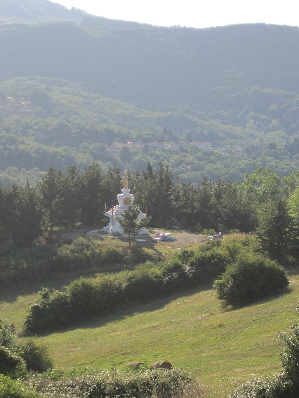
Merigar West
|
Merigar West is a European Dzogchen gar situated on the slopes of Monte Labbro. The temple is named Merigar, which literally means “home of the mountain of fire”, and lies in an area of 50 hectares on the hill above the village of Zancona at Arcidosso.
The Tibetan Centre was founded in 1981 by Namkhai Norbu Rinpoche, with the construction of the farmhouse, called Serkhang (golden house), which includes accommodation of Geko, the custodian, the only permanent resident and manager of the center, the secretariat and canteen. Subsequently, the center has grown in importance with the construction of the library, which holds a large collection of Tibetan texts, and with the Mandala room, the room where the dance of Vajra is practiced. In 1990, in the presence of the Dalai Lama, the Gompa, the Temple of the Great Contemplation was inaugurated while in 1998, the Great Stupa, a reliquary monument that represents the enlightened state of mind was completed.
|
| |
|
|
|
|
 |
|
 |
|
 |
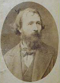
David Lazzaretti
|
|
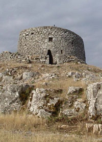
Eremo of David Lazzaretti or Torre Giurisdavidica, Riserva Naturale Monte Labbro
|
|
Merigar West, Monte Labbro |
| |
|
|
|
|
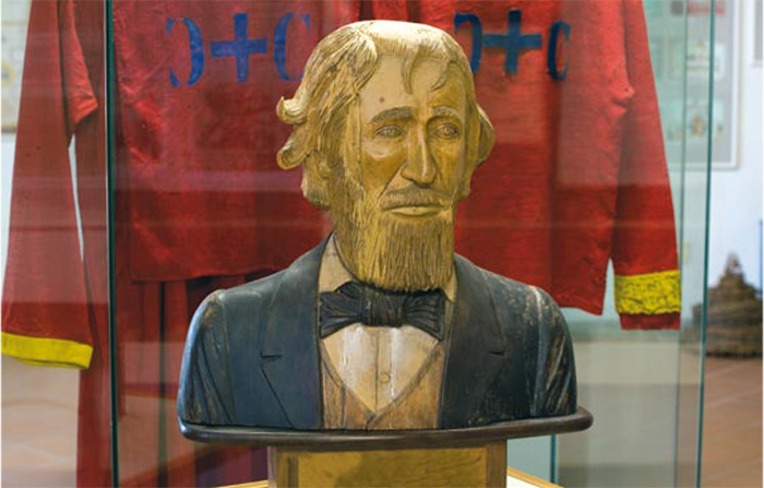
David Lazzaretti Research Center - Arcidosso
The Research Center has been dedicated to David Lazzaretti (1834-1878), “Amiata’s Prophet” who acted as God’s instrument to accomplish an important reformative mission. The social and religious life of Lazzaretti represents a utopian time of great evocative power and participation in the historical background of the Amiata mountains and more generally speaking in the history of the subaltern classes of post-unitary Italy. Through two specific sections: documentary and exhibition, the Center aims to recall the past with the aid of pictures, paintings, clothing, banners and a vast bibliography and archive documentation produced by the Lazzaretti movement; documentation which has been catalogued, sorted and placed at the disposal of researchers and scholars.
|
|
David Lazzaretti
|
Zancona e Le Macchie
Zancona and Le Macchie, settlements that wind along the Zancona river valley, on the northern side of Monte Labbro, were important centers of lumberjacks and loggers, but today there are only a few units left. Zancona was one of the places where David Lazzaretti preached and made many followers. Almost all Jurisdavidic priests who came after David were from Zancona. The archive of the brotherhood is guarded here as well. There is the church of St. Anne. [85] The two centers are known for the production of potatos, and in Le Macchie the sagre della patata is held in August.
|
|
|
|


